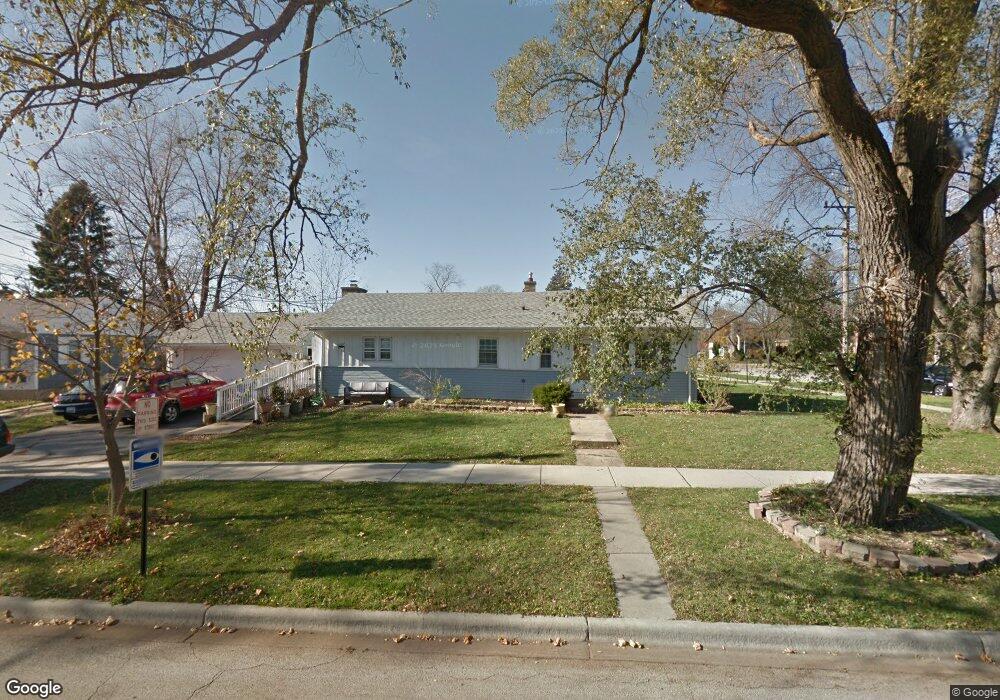
2004 Cedar St Des Plaines, IL 60018
Estimated Value: $363,000 - $425,000
3
Beds
2
Baths
1,200
Sq Ft
$327/Sq Ft
Est. Value
About This Home
This home is located at 2004 Cedar St, Des Plaines, IL 60018 and is currently estimated at $392,512, approximately $327 per square foot. 2004 Cedar St is a home located in Cook County with nearby schools including South Elementary School, Algonquin Middle School, and Maine West High School.
Ownership History
Date
Name
Owned For
Owner Type
Purchase Details
Closed on
Jan 9, 2024
Sold by
Leon Jose A and Leon Miriam N
Bought by
Leon Miriam N and Zavala Gilberto Lopez
Current Estimated Value
Purchase Details
Closed on
Jul 22, 2002
Sold by
Sheehy Raymond D and Sheehy Edna M
Bought by
Leon Jose A and Leon Miriam N
Home Financials for this Owner
Home Financials are based on the most recent Mortgage that was taken out on this home.
Original Mortgage
$206,755
Interest Rate
6.8%
Mortgage Type
FHA
Create a Home Valuation Report for This Property
The Home Valuation Report is an in-depth analysis detailing your home's value as well as a comparison with similar homes in the area
Home Values in the Area
Average Home Value in this Area
Purchase History
| Date | Buyer | Sale Price | Title Company |
|---|---|---|---|
| Leon Miriam N | -- | Chicago Title Insurance Compan | |
| Leon Jose A | $210,000 | -- |
Source: Public Records
Mortgage History
| Date | Status | Borrower | Loan Amount |
|---|---|---|---|
| Previous Owner | Leon Jose A | $206,755 |
Source: Public Records
Tax History
| Year | Tax Paid | Tax Assessment Tax Assessment Total Assessment is a certain percentage of the fair market value that is determined by local assessors to be the total taxable value of land and additions on the property. | Land | Improvement |
|---|---|---|---|---|
| 2025 | $6,508 | $32,000 | $5,917 | $26,083 |
| 2024 | $6,508 | $28,001 | $4,931 | $23,070 |
| 2023 | $6,324 | $28,001 | $4,931 | $23,070 |
| 2022 | $6,324 | $28,001 | $4,931 | $23,070 |
| 2021 | $4,519 | $18,032 | $4,108 | $13,924 |
| 2020 | $4,512 | $18,032 | $4,108 | $13,924 |
| 2019 | $4,530 | $20,261 | $4,108 | $16,153 |
| 2018 | $5,434 | $21,606 | $3,615 | $17,991 |
| 2017 | $5,356 | $21,606 | $3,615 | $17,991 |
| 2016 | $5,310 | $21,606 | $3,615 | $17,991 |
| 2015 | $4,635 | $17,954 | $3,122 | $14,832 |
| 2014 | $4,553 | $17,954 | $3,122 | $14,832 |
| 2013 | $4,422 | $17,954 | $3,122 | $14,832 |
Source: Public Records
Map
Nearby Homes
- 1845 Everett Ave
- 1721 Prospect Ave
- 1640 S River Rd
- 1939 E Touhy Ave
- 1627 Orchard St
- 38 E Touhy Ave
- 1641 E Touhy Ave
- 1629 E Touhy Ave
- 1754 E Lincoln Ave
- 1445 Everett Ave
- 1645 Illinois St
- 1689 S Elm St
- 2600 S Scott St
- 1696 S Elm St
- 2609 Eisenhower Dr
- 2220 S Chestnut St
- 700 Florence Dr
- 2646 Maple St
- 22 Park Ln Unit 203
- 22 Park Ln Unit 220