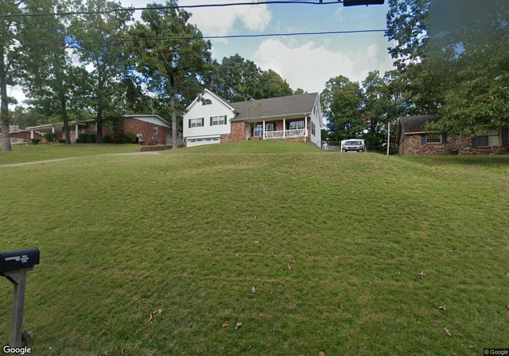
2004 Meadows Rd Poplar Bluff, MO 63901
Estimated Value: $242,426 - $259,000
5
Beds
--
Bath
2,455
Sq Ft
$102/Sq Ft
Est. Value
About This Home
This home is located at 2004 Meadows Rd, Poplar Bluff, MO 63901 and is currently estimated at $251,607, approximately $102 per square foot. 2004 Meadows Rd is a home located in Butler County with nearby schools including O'Neal Elementary School, Poplar Bluff Fifth & Sixth Grade Center, and Poplar Bluff Junior High School.
Ownership History
Date
Name
Owned For
Owner Type
Purchase Details
Closed on
Apr 11, 2017
Sold by
Hobbs Vicki R and Hobbs Vicki L
Bought by
Hobbs Ii James A and Hawkins Karen
Current Estimated Value
Home Financials for this Owner
Home Financials are based on the most recent Mortgage that was taken out on this home.
Original Mortgage
$196,377
Interest Rate
3.87%
Mortgage Type
FHA
Purchase Details
Closed on
Apr 16, 2013
Sold by
Hobbs James A
Bought by
Hobbs Vicki L
Create a Home Valuation Report for This Property
The Home Valuation Report is an in-depth analysis detailing your home's value as well as a comparison with similar homes in the area
Home Values in the Area
Average Home Value in this Area
Purchase History
| Date | Buyer | Sale Price | Title Company |
|---|---|---|---|
| Hobbs Ii James A | -- | First American Title Insuran | |
| Hobbs Vicki L | -- | None Available |
Source: Public Records
Mortgage History
| Date | Status | Borrower | Loan Amount |
|---|---|---|---|
| Closed | Hobbs Ii James A | $196,377 |
Source: Public Records
Tax History
| Year | Tax Paid | Tax Assessment Tax Assessment Total Assessment is a certain percentage of the fair market value that is determined by local assessors to be the total taxable value of land and additions on the property. | Land | Improvement |
|---|---|---|---|---|
| 2025 | $1,692 | $35,870 | $0 | $0 |
| 2024 | $16 | $33,300 | $0 | $0 |
| 2023 | $1,609 | $33,300 | $0 | $0 |
| 2022 | $1,556 | $32,270 | $0 | $0 |
| 2021 | $1,557 | $32,270 | $0 | $0 |
| 2020 | $1,445 | $29,540 | $0 | $0 |
| 2019 | $1,443 | $29,540 | $0 | $0 |
| 2018 | $1,443 | $29,540 | $0 | $0 |
| 2017 | -- | $29,540 | $0 | $0 |
| 2016 | -- | $29,540 | $0 | $0 |
| 2015 | -- | $29,540 | $0 | $0 |
| 2014 | -- | $27,640 | $0 | $0 |
| 2012 | $1,171 | $27,500 | $0 | $0 |
Source: Public Records
Map
Nearby Homes
- 2001 Woodhaven Rd
- 1557 Haven Hills Rd
- 2001 King Rd
- 1301 Lurlyn Rd
- 1915 Old Orchard Rd
- 1715 Big Bend Rd
- 1723 Sunset Dr
- 2305 Lee St
- 2105 Jackson Rd
- 2304 Lee St
- 1604 Big Bend Rd
- 1824 Seifert Dr
- 2601 Forest View St
- 1712 Seifert Dr
- 2418 Channon Dr
- 2420 Channon Dr
- 2310 Earl St
- 2329 Perkins Dr
- 2312 Earl St
- 2214 Trousdale St
- 2008 Meadows Rd
- 2002 Meadows Rd
- 2005 Meadows Rd
- 2012 Meadows Rd
- 5153 NE 1004 Rd
- 2005 Woodhaven Rd
- 2007 Meadows Rd
- 2003 Meadows Rd
- 2011 Woodhaven Rd
- 2009 Meadows Rd
- 2106 Sunset Dr
- 2015 Woodhaven Rd
- 0 Woodhaven Rd
- 2019 Woodhaven Rd
- 2013 Meadows Rd
- 1945 Woodhaven Rd
- 1940 Meadows Rd
- 2004 Woodhaven Rd
- 2010 Woodhaven Rd
- 2018 Meadows Rd
Your Personal Tour Guide
Ask me questions while you tour the home.