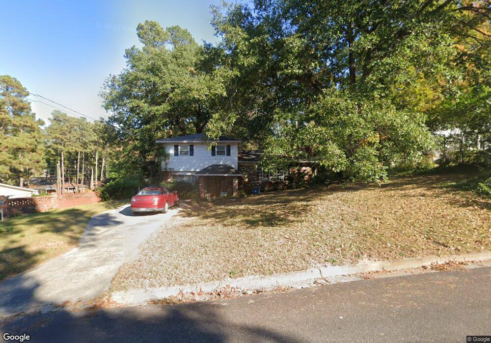
2004 Robin Rd North Augusta, SC 29841
Estimated Value: $196,000 - $271,000
3
Beds
2
Baths
1,782
Sq Ft
$126/Sq Ft
Est. Value
About This Home
This home is located at 2004 Robin Rd, North Augusta, SC 29841 and is currently estimated at $223,984, approximately $125 per square foot. 2004 Robin Rd is a home located in Aiken County with nearby schools including Hammond Hill Elementary School, Paul Knox Middle School, and North Augusta High School.
Ownership History
Date
Name
Owned For
Owner Type
Purchase Details
Closed on
Jul 14, 2011
Sold by
Secretary Of Veterans Affairs
Bought by
Kelly Matthew
Current Estimated Value
Home Financials for this Owner
Home Financials are based on the most recent Mortgage that was taken out on this home.
Original Mortgage
$81,000
Outstanding Balance
$55,348
Interest Rate
4.52%
Mortgage Type
VA
Estimated Equity
$168,636
Purchase Details
Closed on
Feb 11, 2009
Sold by
Gosche Flora D and Gosche Flora G
Bought by
Gosche Jeremy J
Home Financials for this Owner
Home Financials are based on the most recent Mortgage that was taken out on this home.
Original Mortgage
$96,356
Interest Rate
5.07%
Mortgage Type
VA
Purchase Details
Closed on
Aug 27, 2004
Sold by
Mclendon Jeffrey D
Bought by
Gosche Jeremy J and Gosche Flora D
Create a Home Valuation Report for This Property
The Home Valuation Report is an in-depth analysis detailing your home's value as well as a comparison with similar homes in the area
Purchase History
| Date | Buyer | Sale Price | Title Company |
|---|---|---|---|
| Kelly Matthew | $81,000 | -- | |
| Gosche Jeremy J | -- | -- | |
| Gosche Jeremy J | $95,000 | -- |
Source: Public Records
Mortgage History
| Date | Status | Borrower | Loan Amount |
|---|---|---|---|
| Open | Kelly Matthew | $81,000 | |
| Previous Owner | Gosche Jeremy J | $96,356 |
Source: Public Records
Tax History
| Year | Tax Paid | Tax Assessment Tax Assessment Total Assessment is a certain percentage of the fair market value that is determined by local assessors to be the total taxable value of land and additions on the property. | Land | Improvement |
|---|---|---|---|---|
| 2025 | $531 | $5,300 | -- | -- |
| 2023 | $532 | $5,310 | $824 | $130,530 |
| 2022 | $518 | $6,180 | $0 | $0 |
| 2021 | $519 | $6,180 | $0 | $0 |
| 2020 | $458 | $4,620 | $0 | $0 |
| 2019 | $458 | $4,620 | $0 | $0 |
| 2018 | $459 | $4,620 | $600 | $4,020 |
| 2017 | $436 | $0 | $0 | $0 |
| 2016 | $437 | $0 | $0 | $0 |
| 2015 | $480 | $0 | $0 | $0 |
| 2014 | $481 | $0 | $0 | $0 |
| 2013 | -- | $0 | $0 | $0 |
Source: Public Records
Map
Nearby Homes
- 2009 Wren Rd
- 1926 Robin Rd
- 817 Bobbye Dr Unit Fb77
- 37 Hillwood Ct
- 655 Bobbye Dr Unit Fb67
- 15 Summit Commons Ct
- 639 Caroline Ct Unit 7c
- 633 Caroline Ct Unit 7b
- 623 Caroline Ct Unit 8d
- 617 Caroline Ct Unit 8c
- 613 Caroline Ct Unit 8b
- 1071 Bobbye Dr Unit 13a
- 1087 Bobbye Dr Unit 13b
- 1105 Bobbye Dr Unit 12a
- 1121 Bobbye Dr Unit 12b
- 4027 Jane Ln Unit 10B
- 2006 Bunting Dr
- 379 Bobbye Dr Unit Fb94
- 5250 Anna Creek Way Unit Fb95
- 5236 Anna Creek Way Unit Fb96
- 2006 Robin Rd
- 1927 Bunting Dr
- 1925 Bunting Dr
- 2008 Robin Rd
- 1929 Bunting Dr
- 1914 Bobolink Ave
- 1912 Bobolink Ave
- 1916 Bobolink Ave
- 1931 Bunting Dr
- 1919 Bunting Dr
- 2003 Robin Rd
- 2010 Robin Rd
- 2005 Robin Rd
- 2007 Robin Rd
- 1930 Bunting Dr
- 1935 Bunting Dr
- 1908 Bobolink Ave
- 1928 Bunting Dr
- 1917 Bunting Dr
- 1932 Bunting Dr
Your Personal Tour Guide
Ask me questions while you tour the home.