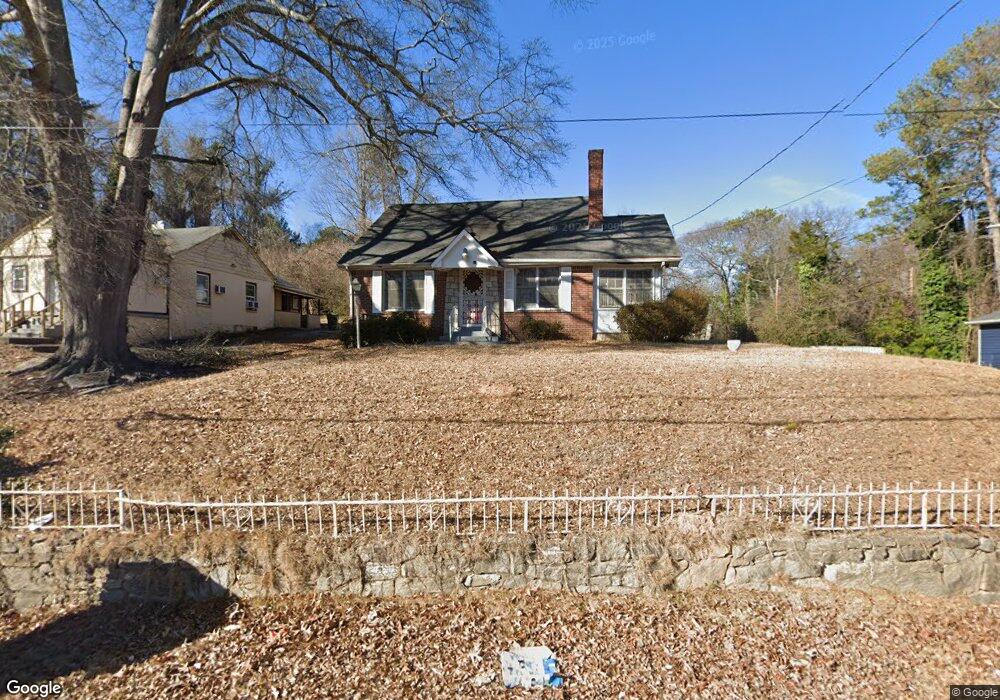
2005 Baker Rd NW Atlanta, GA 30318
Grove Park NeighborhoodEstimated Value: $244,698 - $258,000
3
Beds
1
Bath
1,658
Sq Ft
$152/Sq Ft
Est. Value
About This Home
This home is located at 2005 Baker Rd NW, Atlanta, GA 30318 and is currently estimated at $252,675, approximately $152 per square foot. 2005 Baker Rd NW is a home located in Fulton County with nearby schools including Frederick Douglass High School, KIPP Atlanta Collegiate, and Berean Christian Jr Academy.
Ownership History
Date
Name
Owned For
Owner Type
Purchase Details
Closed on
Jan 30, 2019
Sold by
Southern State Investments Llc
Bought by
Smith Johnathan Keith
Current Estimated Value
Purchase Details
Closed on
Feb 18, 2018
Sold by
Deed Co Inc
Bought by
Nr Deed Llc
Purchase Details
Closed on
Oct 4, 2016
Sold by
Laleeta L
Bought by
Deed Co Inc
Purchase Details
Closed on
Dec 1, 1995
Sold by
Williams Tanya M
Bought by
Smith Laleeta L
Create a Home Valuation Report for This Property
The Home Valuation Report is an in-depth analysis detailing your home's value as well as a comparison with similar homes in the area
Home Values in the Area
Average Home Value in this Area
Purchase History
| Date | Buyer | Sale Price | Title Company |
|---|---|---|---|
| Smith Johnathan Keith | $105,000 | -- | |
| Southern State Investments Llc | $83,500 | -- | |
| Nr Deed Llc | -- | -- | |
| Deed Co Inc | $19,480 | -- | |
| Smith Laleeta L | $50,000 | -- |
Source: Public Records
Mortgage History
| Date | Status | Borrower | Loan Amount |
|---|---|---|---|
| Closed | Smith Laleeta L | $0 |
Source: Public Records
Tax History Compared to Growth
Tax History
| Year | Tax Paid | Tax Assessment Tax Assessment Total Assessment is a certain percentage of the fair market value that is determined by local assessors to be the total taxable value of land and additions on the property. | Land | Improvement |
|---|---|---|---|---|
| 2025 | $2,838 | $89,480 | $36,680 | $52,800 |
| 2023 | $3,683 | $88,960 | $36,680 | $52,280 |
| 2022 | $3,220 | $79,560 | $23,160 | $56,400 |
| 2021 | $1,972 | $48,680 | $24,040 | $24,640 |
| 2020 | $1,391 | $33,960 | $13,520 | $20,440 |
| 2019 | $488 | $24,960 | $3,080 | $21,880 |
| 2018 | $720 | $17,400 | $1,480 | $15,920 |
| 2017 | $752 | $17,400 | $1,480 | $15,920 |
| 2016 | $1,032 | $23,840 | $3,040 | $20,800 |
| 2015 | $1,517 | $23,840 | $3,040 | $20,800 |
| 2014 | $903 | $19,920 | $5,120 | $14,800 |
Source: Public Records
Map
Nearby Homes
- 2009 Baker Rd NW
- 2001 Arlington Cir NW
- 0 S Eugenia Place NW Unit 10498281
- 500 Emily Reed Ln
- 1938 Maywood Place NW
- 2031 North Ave NW
- 614 Charlotte Place NW
- 1964 North Ave NW
- 2032 North Ave NW
- 665 S Eugenia Place NW
- 1914 North Ave NW
- 2058 North Ave NW
- 2097 Baker Rd NW
- 1876 Madrona St NW
- 2030 Detroit Ave NW
- 0 Detroit Ave NW Unit 10612853
- 1937 Detroit Ave NW
- 2015 Baker Rd NW
- 2015 Baker Rd NW Unit B
- 1999 Baker Rd NW
- 2008 Arlington Cir NW
- 2018 Arlington Cir NW
- 2021 Baker Rd NW
- 1993 Baker Rd NW
- 2024 Arlington Cir NW
- 2000 Baker Rd NW
- 1997 Arlington Cir NW
- 1996 Baker Rd NW
- 2026 Arlington Cir NW
- 1986 Baker Rd NW
- 2025 Baker Rd NW
- 1990 Baker Rd NW
- 1989 Baker Rd NW
- 2010 Baker Rd NW
- 2016 Baker Rd NW
- 1982 Baker Rd NW
- 2028 Arlington Cir NW