Estimated Value: $645,000 - $727,000
4
Beds
3
Baths
2,516
Sq Ft
$272/Sq Ft
Est. Value
About This Home
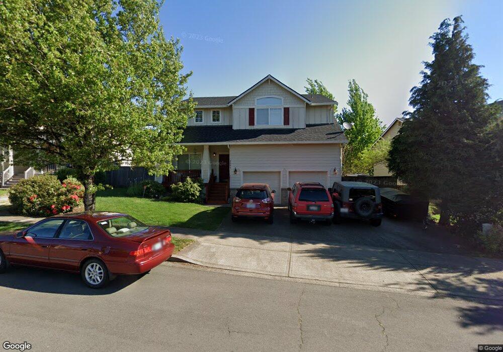
This home is located at 2005 NW Fargo Loop, Camas, WA 98607 and is currently estimated at $684,367, approximately $272 per square foot. 2005 NW Fargo Loop is a home located in Clark County with nearby schools including Helen Baller Elementary School, Liberty Middle School, and Camas High School.
Ownership History
Date
Name
Owned For
Owner Type
Purchase Details
Closed on
Jan 29, 2003
Sold by
Harbour Homes Inc
Bought by
Oliver Jeffrey A and Ruse Shauna M
Current Estimated Value
Home Financials for this Owner
Home Financials are based on the most recent Mortgage that was taken out on this home.
Original Mortgage
$171,000
Outstanding Balance
$72,593
Interest Rate
5.83%
Estimated Equity
$611,774
Purchase Details
Closed on
Feb 20, 2002
Sold by
Shiloh Heights Llc
Bought by
Geonerco Inc
Home Financials for this Owner
Home Financials are based on the most recent Mortgage that was taken out on this home.
Original Mortgage
$1,745,000
Interest Rate
7.04%
Create a Home Valuation Report for This Property
The Home Valuation Report is an in-depth analysis detailing your home's value as well as a comparison with similar homes in the area
Purchase History
| Date | Buyer | Sale Price | Title Company |
|---|---|---|---|
| Oliver Jeffrey A | $213,750 | Chicago Title Insurance | |
| Geonerco Inc | -- | First American Title Ins Co |
Source: Public Records
Mortgage History
| Date | Status | Borrower | Loan Amount |
|---|---|---|---|
| Open | Oliver Jeffrey A | $171,000 | |
| Previous Owner | Geonerco Inc | $1,745,000 | |
| Closed | Oliver Jeffrey A | $21,350 |
Source: Public Records
Tax History
| Year | Tax Paid | Tax Assessment Tax Assessment Total Assessment is a certain percentage of the fair market value that is determined by local assessors to be the total taxable value of land and additions on the property. | Land | Improvement |
|---|---|---|---|---|
| 2025 | $6,112 | $561,868 | $160,000 | $401,868 |
| 2024 | $6,012 | $641,178 | $256,000 | $385,178 |
| 2023 | $5,498 | $678,051 | $224,000 | $454,051 |
| 2022 | $5,484 | $589,624 | $209,600 | $380,024 |
| 2021 | $5,380 | $491,600 | $176,000 | $315,600 |
| 2020 | $5,598 | $447,007 | $160,000 | $287,007 |
| 2019 | $5,871 | $431,342 | $160,000 | $271,342 |
| 2018 | $5,337 | $481,928 | $0 | $0 |
| 2017 | $5,090 | $368,216 | $0 | $0 |
| 2016 | $4,506 | $382,443 | $0 | $0 |
Source: Public Records
Map
Nearby Homes
- 2120 NW Fargo Loop
- 336 NW 17th Ave
- 2512 NW Logan St
- 536 NW 10th Ave
- 2556 NW Norwood St
- 541 NW 8th Ave
- 2415 NW Norwood Place
- 615 NW 7th Ave
- 715 NE 22nd Ave
- 419 NE 7th Ave
- 635 NE Dallas St
- 622 NW Hill St
- 1851 NW 26th Ave
- 3334 NW 17th Ave
- 802 NW 5th Cir Unit 802
- 1641 NW 31st Ave
- 660 NW Norwood St
- 1627 NW 35th Cir
- 2546 NW 16th Ave
- 3313 NW Sierra Dr
- 2001 NW Fargo Loop
- 2011 NW Fargo Loop
- 2033 NW Fargo Ct
- 2044 NW Fargo Ct
- 2002 NW Fargo Loop
- 2017 NW Fargo Loop
- 2041 NW Fargo Ct
- 2046 NW Fargo Ct
- 2006 NW Fargo Loop
- 2010 NW Fargo Loop
- 2015 NW Fargo St
- 2014 NW Fargo Loop
- 2021 NW Fargo Loop
- 2035 NW Fargo Loop
- 2053 NW Fargo Ct
- 710 NW 20th Ave
- 2043 NW Fargo Loop
- 2055 NW Fargo Loop
- 643 NW 19th Ave
- 2113 NW Fargo Loop
Your Personal Tour Guide
Ask me questions while you tour the home.