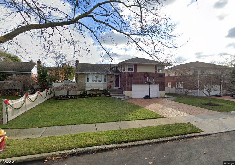
2006 Debra Ct Merrick, NY 11566
Estimated Value: $847,486 - $937,000
--
Bed
3
Baths
1,341
Sq Ft
$665/Sq Ft
Est. Value
About This Home
This home is located at 2006 Debra Ct, Merrick, NY 11566 and is currently estimated at $892,243, approximately $665 per square foot. 2006 Debra Ct is a home located in Nassau County with nearby schools including Burcham Elementary School, Merrick Avenue Middle School, and Waynoka High School.
Ownership History
Date
Name
Owned For
Owner Type
Purchase Details
Closed on
Jun 14, 2010
Sold by
Stamm Richard and Stamm Margaret
Bought by
Cancellarich Dennis and Cancellarich Lotus
Current Estimated Value
Home Financials for this Owner
Home Financials are based on the most recent Mortgage that was taken out on this home.
Original Mortgage
$452,000
Outstanding Balance
$303,080
Interest Rate
4.98%
Mortgage Type
Purchase Money Mortgage
Estimated Equity
$589,163
Purchase Details
Closed on
Sep 24, 1998
Sold by
Griski Vincent and Griski Lois
Bought by
Stamm Richard and Stamm Margaret
Create a Home Valuation Report for This Property
The Home Valuation Report is an in-depth analysis detailing your home's value as well as a comparison with similar homes in the area
Home Values in the Area
Average Home Value in this Area
Purchase History
| Date | Buyer | Sale Price | Title Company |
|---|---|---|---|
| Cancellarich Dennis | $565,000 | -- | |
| Stamm Richard | $279,000 | -- |
Source: Public Records
Mortgage History
| Date | Status | Borrower | Loan Amount |
|---|---|---|---|
| Open | Cancellarich Dennis | $452,000 |
Source: Public Records
Tax History Compared to Growth
Tax History
| Year | Tax Paid | Tax Assessment Tax Assessment Total Assessment is a certain percentage of the fair market value that is determined by local assessors to be the total taxable value of land and additions on the property. | Land | Improvement |
|---|---|---|---|---|
| 2025 | $14,220 | $491 | $183 | $308 |
| 2024 | $3,715 | $522 | $194 | $328 |
| 2023 | $12,799 | $543 | $202 | $341 |
| 2022 | $12,799 | $543 | $202 | $341 |
| 2021 | $13,846 | $550 | $186 | $364 |
| 2020 | $9,684 | $631 | $562 | $69 |
| 2019 | $10,344 | $676 | $384 | $292 |
| 2018 | $10,444 | $1,061 | $0 | $0 |
| 2017 | $10,392 | $1,061 | $602 | $459 |
| 2016 | $15,138 | $1,061 | $602 | $459 |
| 2015 | $4,382 | $1,061 | $602 | $459 |
| 2014 | $4,382 | $1,061 | $602 | $459 |
| 2013 | $4,093 | $1,061 | $602 | $459 |
Source: Public Records
Map
Nearby Homes
- 37 Orchard St
- 1531 Merrick Ave
- 843 Jerusalem Ave
- 2207 Van Nostrand Ave
- 2005 Abbot Ave
- 1360 Powell Ave
- 1580 Little Whaleneck Rd
- 526 Park Ave
- 2245 Van Nostrand Ave
- 1706 Old Mill Rd
- 1617 Richard Ave
- 101 Northridge Ave
- 2360 Hamilton Rd
- 1680 Lake Ave
- 1750 Henry Rd
- 1448 Dewey Ave
- 1974 Monroe Ave
- 12 Washington Dr
- 1346 Bellmore Ave
- 2 Garfield St