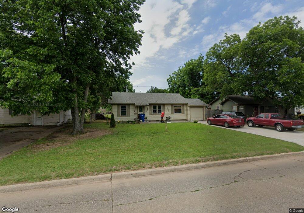
2006 W Beech Ave Duncan, OK 73533
Estimated Value: $59,000 - $82,000
2
Beds
1
Bath
962
Sq Ft
$75/Sq Ft
Est. Value
About This Home
This home is located at 2006 W Beech Ave, Duncan, OK 73533 and is currently estimated at $72,083, approximately $74 per square foot. 2006 W Beech Ave is a home located in Stephens County with nearby schools including Mark Twain Elementary School, Duncan Middle School, and Duncan High School.
Ownership History
Date
Name
Owned For
Owner Type
Purchase Details
Closed on
May 31, 2016
Sold by
Mbr Properties Llc
Bought by
Falcone Kelly and Borchardt Kris
Current Estimated Value
Purchase Details
Closed on
Nov 8, 2011
Sold by
Ramsey Brad K and Ramsey Any J
Bought by
Mbr Properties Llc
Purchase Details
Closed on
Oct 12, 2000
Sold by
Mills Elgene and Mills Margie
Purchase Details
Closed on
Feb 24, 2000
Sold by
Foley Nancy J
Purchase Details
Closed on
Nov 30, 1992
Sold by
Mcguire Allen
Purchase Details
Closed on
Sep 2, 1992
Sold by
Etheridge Clifford
Create a Home Valuation Report for This Property
The Home Valuation Report is an in-depth analysis detailing your home's value as well as a comparison with similar homes in the area
Purchase History
| Date | Buyer | Sale Price | Title Company |
|---|---|---|---|
| Falcone Kelly | $40,000 | None Available | |
| Mbr Properties Llc | -- | None Available | |
| -- | $26,500 | -- | |
| -- | $21,000 | -- | |
| -- | $11,000 | -- | |
| -- | $5,500 | -- |
Source: Public Records
Tax History
| Year | Tax Paid | Tax Assessment Tax Assessment Total Assessment is a certain percentage of the fair market value that is determined by local assessors to be the total taxable value of land and additions on the property. | Land | Improvement |
|---|---|---|---|---|
| 2025 | $341 | $5,052 | $712 | $4,340 |
| 2024 | $320 | $4,762 | $712 | $4,050 |
| 2023 | $320 | $4,762 | $712 | $4,050 |
| 2022 | $297 | $4,608 | $712 | $3,896 |
| 2021 | $287 | $4,372 | $712 | $3,660 |
| 2020 | $279 | $4,231 | $712 | $3,519 |
| 2019 | $298 | $4,449 | $712 | $3,737 |
| 2018 | $296 | $4,320 | $712 | $3,608 |
| 2017 | $298 | $4,464 | $712 | $3,752 |
| 2016 | $410 | $4,822 | $679 | $4,143 |
| 2015 | $393 | $4,592 | $613 | $3,979 |
| 2014 | $393 | $4,373 | $550 | $3,823 |
Source: Public Records
Map
Nearby Homes
- 1905 W Ash Ave
- 2006 W Oak Ave
- 413 N 20th St
- 174831 N 2844 Rd
- 209 N 22nd St
- 416 N 19th St
- 2150 W Main St
- 2002 Redbud Ave
- 2210 Western Dr
- 507 N Alice Dr
- 1909 W Spruce Ave
- 27 N 14th St
- 1314 W Beech Ave
- 1309 W Beech Ave
- 261 N 29th St
- 1099 N 19th St
- 1817 W Parkview Ave
- 1312 W Pine Ave
- 0 W Beech Ave
- 903 N Harville Rd
- 2008 W Beech Ave
- 2004 W Beech Ave
- 2010 W Beech Ave
- 2002 W Beech Ave
- 2005 W Ash Ave
- 2003 W Ash Ave
- 2007 W Ash Ave
- 2001 W Ash Ave
- 2012 W Beech Ave
- 2009 W Ash Ave
- 168786 N 2812 Rd
- 171531 N 2890 Rd
- 279551 E 1690 Rd
- 168530 N 2800 Rd
- 171508 N 2890 Rd
- 280977 E 1690 Rd
- 280335 E 1680 Rd
- 176773 N 2810 Rd
- 168178 S Hillside Dr
- 171503 N 2890 Rd
Your Personal Tour Guide
Ask me questions while you tour the home.