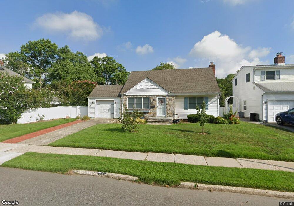
2007 Brian Dr Merrick, NY 11566
Estimated Value: $759,734 - $815,000
Studio
2
Baths
1,472
Sq Ft
$535/Sq Ft
Est. Value
About This Home
This home is located at 2007 Brian Dr, Merrick, NY 11566 and is currently estimated at $787,367, approximately $534 per square foot. 2007 Brian Dr is a home located in Nassau County with nearby schools including Merrick Avenue Middle School, Sanford H Calhoun High School, and Sacred Heart School.
Ownership History
Date
Name
Owned For
Owner Type
Purchase Details
Closed on
Feb 22, 2008
Sold by
Milissis George
Current Estimated Value
Purchase Details
Closed on
Apr 23, 1998
Sold by
Hunter Michael M and Hunter Chapala I
Bought by
Milissis Geroge and Podgorska Malgorzata
Purchase Details
Closed on
Dec 9, 1994
Sold by
Nokes Hazel Est
Bought by
Hunter Michael and Hunter Chapala
Home Financials for this Owner
Home Financials are based on the most recent Mortgage that was taken out on this home.
Original Mortgage
$158,400
Interest Rate
7.84%
Create a Home Valuation Report for This Property
The Home Valuation Report is an in-depth analysis detailing your home's value as well as a comparison with similar homes in the area
Home Values in the Area
Average Home Value in this Area
Purchase History
| Date | Buyer | Sale Price | Title Company |
|---|---|---|---|
| -- | -- | -- | |
| Milissis Geroge | $215,000 | -- | |
| Hunter Michael | $176,000 | -- |
Source: Public Records
Mortgage History
| Date | Status | Borrower | Loan Amount |
|---|---|---|---|
| Previous Owner | Hunter Michael | $158,400 |
Source: Public Records
Tax History
| Year | Tax Paid | Tax Assessment Tax Assessment Total Assessment is a certain percentage of the fair market value that is determined by local assessors to be the total taxable value of land and additions on the property. | Land | Improvement |
|---|---|---|---|---|
| 2025 | $12,858 | $481 | $176 | $305 |
| 2024 | $3,814 | $535 | $195 | $340 |
Source: Public Records
Map
Nearby Homes
- 37 Orchard St
- 25 Old Mill Rd
- 116 Winifred Dr
- 1531 Merrick Ave
- 1844 Old Mill Rd
- 204 Maeder Ave
- 34 Shaw Dr
- 840 Jerusalem Ave
- 1817 Gardenia Ave
- 1415 Rhode Ave
- 2016 Abbot Ave
- 20 Iris Ave
- 526 Park Ave
- 1261 Meadowbrook Rd
- 1526 Rhode Ave
- 45 Richard Ave
- 1563 Stevens Ave
- 1617 Richard Ave
- 2360 Hamilton Rd
- 1680 Lake Ave
- 2013 Brian Dr
- 252 Little Whaleneck Rd
- 2000 Debra Ct
- 1992 Debra Ct
- 2006 Debra Ct
- 2019 Brian Dr
- 2006 Brian Dr
- 2012 Brian Dr
- 2018 Brian Dr
- 2012 Debra Ct
- 2000 Brian Dr
- 2025 Brian Dr
- 1352 Little Whaleneck Rd
- 1396 Van Nostrand Place
- 2024 Brian Dr
- 1993 Debra Ct
- 1402 Van Nostrand Place
- 21 Cedar St
- 21 Cedar St
- 2016 Debra Ct
Your Personal Tour Guide
Ask me questions while you tour the home.