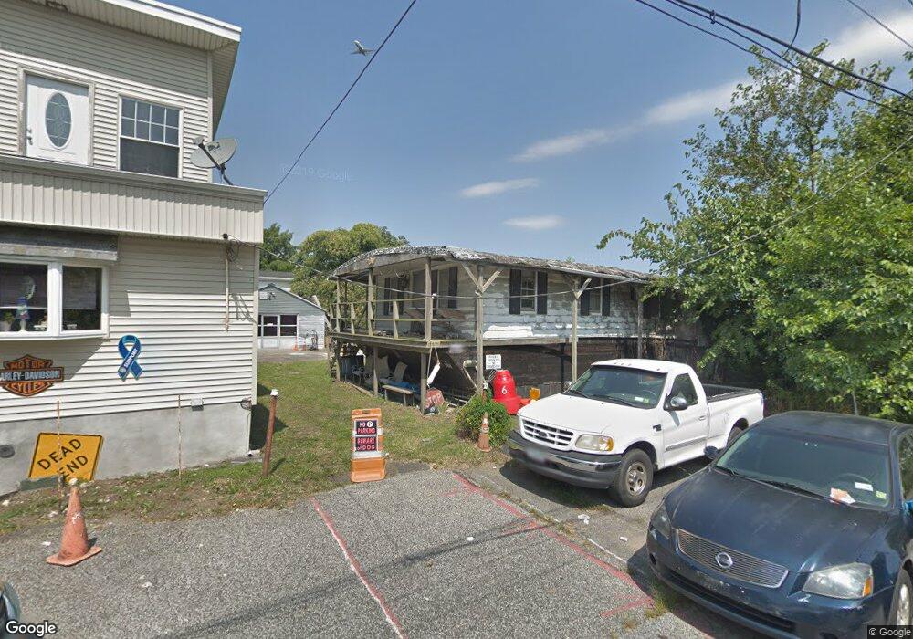
2007 Cornell Ave Bronx, NY 10473
Clason Point NeighborhoodEstimated Value: $492,702 - $595,000
Studio
--
Bath
1,200
Sq Ft
$461/Sq Ft
Est. Value
About This Home
This home is located at 2007 Cornell Ave, Bronx, NY 10473 and is currently estimated at $552,926, approximately $460 per square foot. 2007 Cornell Ave is a home located in Bronx County with nearby schools including P.S. 182 and Holy Cross Elementary School.
Ownership History
Date
Name
Owned For
Owner Type
Purchase Details
Closed on
Jan 21, 2022
Sold by
Mcgrath John
Bought by
Mcgrath John and Stratmann Adrienne
Current Estimated Value
Purchase Details
Closed on
Feb 17, 2009
Sold by
Mcgrath James and Mcgrath John
Bought by
Mcgrath John
Purchase Details
Closed on
Aug 1, 1997
Sold by
Mcgrath John and Mcgrath Robert
Bought by
Mcgrath John and Mcgrath James
Create a Home Valuation Report for This Property
The Home Valuation Report is an in-depth analysis detailing your home's value as well as a comparison with similar homes in the area
Home Values in the Area
Average Home Value in this Area
Purchase History
| Date | Buyer | Sale Price | Title Company |
|---|---|---|---|
| Mcgrath John | -- | -- | |
| Mcgrath John | -- | -- | |
| Mcgrath John | -- | -- | |
| Mcgrath John | -- | -- | |
| Mcgrath John | -- | Judicial Title | |
| Mcgrath John | -- | Judicial Title |
Source: Public Records
Tax History
| Year | Tax Paid | Tax Assessment Tax Assessment Total Assessment is a certain percentage of the fair market value that is determined by local assessors to be the total taxable value of land and additions on the property. | Land | Improvement |
|---|---|---|---|---|
| 2025 | $4,253 | $23,927 | $6,961 | $16,966 |
| 2024 | $4,253 | $22,573 | $5,949 | $16,624 |
| 2023 | $4,041 | $21,299 | $5,837 | $15,462 |
| 2022 | $3,965 | $29,820 | $9,060 | $20,760 |
| 2021 | $4,145 | $29,460 | $9,060 | $20,400 |
| 2020 | $3,925 | $32,520 | $9,060 | $23,460 |
| 2019 | $3,642 | $33,540 | $9,060 | $24,480 |
| 2018 | $3,320 | $17,749 | $5,115 | $12,634 |
| 2017 | $3,318 | $17,749 | $7,224 | $10,525 |
| 2016 | $3,211 | $17,612 | $7,891 | $9,721 |
| 2015 | $1,800 | $16,616 | $8,751 | $7,865 |
| 2014 | $1,800 | $15,676 | $9,081 | $6,595 |
Source: Public Records
Map
Nearby Homes
- 109 Dolphin Ct
- 127 Husson Ave
- 101 Surf Dr Unit 23
- 109 Fleet Ct
- 100 Neptune Ln Unit 15100
- 122 Stephens Ave
- 169 Surf Dr Unit 109
- 163 Surf Dr Unit 199
- 197 Surf Dr Unit 123
- 179 Surf Dr Unit 114
- 160 Stephens Ave
- 114 Beacon Ln Unit 74
- 170 Soundview Ave
- 219 Surf Dr Unit 134B
- 132 Sunset Blvd Unit 11132
- 126 Mermaid Ln Unit 174
- 230 Fleet Ct Unit 16230
- 234 Betts Ave
- 227 Stephens Ave
- 203 White Plains Rd
- 2005 Cornell Ave
- 108 Husson Ave
- 106 Husson Ave
- 112 Husson Ave
- 113 Lighthouse Ct
- 118 Husson Ave
- 2000 Cornell Ave
- 112 Dolphin Ct
- 101 Husson Ave
- 111 Lighthouse Ct
- 120 Husson Ave
- 112 Lighthouse Ct
- 110 Dolphin Ct
- 1999 Cornell Ave
- 109 Lighthouse Ct Unit A
- 109 Lighthouse Ct
- 109 Lighthouse Ct Unit B
- 110 Lighthouse Ct
- 122 Husson Ave
- 108 Dolphin Ct Unit A