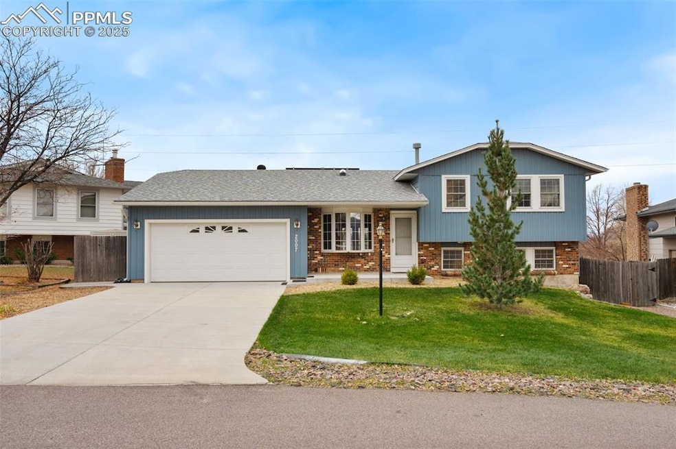
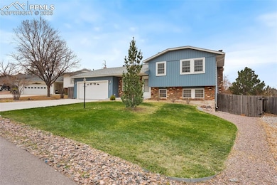
2007 Flintlock Terrace E Colorado Springs, CO 80920
Briargate NeighborhoodEstimated payment $2,310/month
Highlights
- Hot Property
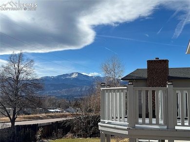
- Views of Pikes Peak
- Wood Flooring
- Rampart High School Rated A-
- Solar Power System
- Cul-De-Sac
About This Home
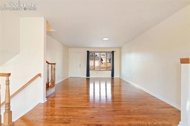
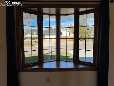
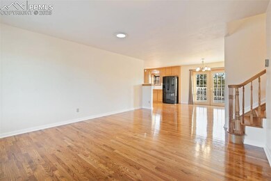
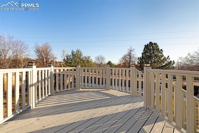
This Incredibly, beautifully updated, Briargate Tri-level home in D-20 features 4 bedrooms & an open floor plan. It boasts stunning views of Pikes Peak & the Front Range, with every window having a mountain view. It is situated on a quiet cul-de-sac & sits on nearly a quarter-acre fenced lot, with immaculate & attractive landscaping. The interior has been freshly painted in an elegant neutral color. The Main Level boasts gleaming Hardwood Floors, while the Bedrooms & Family Room have New Carpeting. Offering a perfect blend of style, comfort, & functionality, the open-concept Main Floor, featuring a Bay Window & a tubular Skylight, is bathed in natural light, creating a warm & inviting atmosphere throughout. The spacious Living Room flows effortlessly into the Dining Area & an amazing Kitchen. The Kitchen features an Atrium Window & a tubular Skylight, offering ample cabinet storage along with all appliances, including a brand-new GE Dishwasher. Adjoining Dining Area has double doors that lead out to the deck, making it perfect for relaxing and entertaining. The Tri-level floor plan provides separation & privacy for the 3 bright and cheerful Bedrooms, along with a full, previously remodeled 5-piece Bathroom on the upper level. The spacious Primary Bedroom features 2 large windows facing the mountains, built-in shelves, a double closet, & a door leading to the main bathroom. The stunning garden-level spacious Family Room, features built-in bookcases & a striking Brick Wall Wood Burning Fireplace. There is a delightful garden-level Bedroom off the family room, along with a Laundry Rm featuring a Washer & Dryer, as well as an adorable Bathroom. Laundry Room has an access door to a large crawl space area where the furnace replaced in 2019 is situated. The house features fully paid-off solar panels, central A/C, a sprinkler system, & an oversized 2-car garage with space for a workshop. Close to shopping, restaurants, I-25, & the Air Force Academy. A Must See Home!
Listing Agent
Equity Colorado Real Estate Brokerage Phone: 720-722-3209 Listed on: 12/04/2025

Home Details
Home Type
- Single Family
Est. Annual Taxes
- $1,286
Year Built
- Built in 1978
Lot Details
- 9,365 Sq Ft Lot
- Cul-De-Sac
- Back Yard Fenced
- Landscaped
Parking
- 2 Car Attached Garage
- Oversized Parking
- Workshop in Garage
- Garage Door Opener
- Driveway
Property Views
- Pikes Peak
- Mountain
Home Design
- Tri-Level Property
- Brick Exterior Construction
- Shingle Roof
- Aluminum Siding
Interior Spaces
- 1,752 Sq Ft Home
- Ceiling Fan
- Skylights
- Fireplace Features Masonry
- Walk-Out Basement
Kitchen
- Microwave
- Dishwasher
- Disposal
Flooring
- Wood
- Carpet
- Ceramic Tile
- Luxury Vinyl Tile
Bedrooms and Bathrooms
- 4 Bedrooms
Laundry
- Laundry Room
- Laundry on lower level
- Dryer
- Washer
Outdoor Features
- Concrete Porch or Patio
- Shed
Utilities
- Forced Air Heating and Cooling System
- Heating System Uses Natural Gas
- 220 Volts in Kitchen
Additional Features
- Ramped or Level from Garage
- Solar Power System
- Property is near shops
Map
Home Values in the Area
Average Home Value in this Area
Tax History
| Year | Tax Paid | Tax Assessment Tax Assessment Total Assessment is a certain percentage of the fair market value that is determined by local assessors to be the total taxable value of land and additions on the property. | Land | Improvement |
|---|---|---|---|---|
| 2025 | $1,722 | $29,470 | -- | -- |
| 2024 | $1,225 | $30,670 | $5,360 | $25,310 |
| 2022 | $1,013 | $21,300 | $4,340 | $16,960 |
| 2021 | $1,120 | $21,910 | $4,460 | $17,450 |
| 2020 | $996 | $19,390 | $3,720 | $15,670 |
| 2019 | $986 | $19,390 | $3,720 | $15,670 |
| 2018 | $657 | $15,220 | $2,880 | $12,340 |
| 2017 | $655 | $15,220 | $2,880 | $12,340 |
| 2016 | $738 | $16,990 | $2,930 | $14,060 |
| 2015 | $1,386 | $16,990 | $2,930 | $14,060 |
| 2014 | $1,296 | $15,880 | $2,930 | $12,950 |
Property History
| Date | Event | Price | List to Sale | Price per Sq Ft |
|---|---|---|---|---|
| 12/04/2025 12/04/25 | For Sale | $420,000 | -- | $240 / Sq Ft |
Purchase History
| Date | Type | Sale Price | Title Company |
|---|---|---|---|
| Warranty Deed | $112,950 | -- | |
| Deed | -- | -- | |
| Deed | -- | -- |
Mortgage History
| Date | Status | Loan Amount | Loan Type |
|---|---|---|---|
| Closed | $115,209 | VA |
Source: Pikes Peak REALTOR® Services
MLS Number: 2842271
APN: 63043-02-047
Disclaimer: Certain information contained herein is derived from information provided by parties other than Homes.com. All information provided is deemed reliable, but is not guaranteed to be accurate and should be independently verified.
![]() IDX information is provided exclusively for personal, non-commercial use, and may not be used for any purpose other than to identify prospective properties consumers may be interested in purchasing. Information is deemed reliable but not guaranteed.
IDX information is provided exclusively for personal, non-commercial use, and may not be used for any purpose other than to identify prospective properties consumers may be interested in purchasing. Information is deemed reliable but not guaranteed.
- 2107 Peacemaker Terrace W
- 1906 Independence Dr
- 2217 Peacemaker Terrace E
- 1880 Independence Dr
- 7643 Stampede Dr
- 2068 Silkwood Dr
- 7424 Bell Dr
- 2006 Summerset Dr
- 8161 Regiment Ct
- 2512 Elite Terrace
- 7191 Ross Dr
- 2661 Zephyr Dr
- 8335 Sutterfield Dr
- 2270 Cloverdale Dr
- 7849 Flicker Grove
- 2281 Havenridge Dr
- 2768 Thrush Grove
- 2340 Winstead View
- 2326 Parliament Dr
- 7420 Lomas Ct
- 1510-1550 Chapel Hills Dr
- 8175 Summerset Dr
- 7940 Brayden Point
- 2720 Mirage Dr
- 2925 Rhapsody Dr
- 7623 Safari Cir
- 7522 Madrid Ct
- 7755 Kaleb Grove
- 6731 Dublin Loop W Unit D
- 6731 Dublin Loop W Unit B
- 970 Menlo Park Point
- 6750 Alpine Currant View
- 6659 Gambol Quail Dr E
- 2880 Woodland Hills Dr
- 2845 Freewood Point
- 1721 Telstar St
- 8015 Siltstone Point
- 7528 Liberty Bell Dr
- 2915 Woodland Hills Dr
- 7429 Liberty Bell Dr