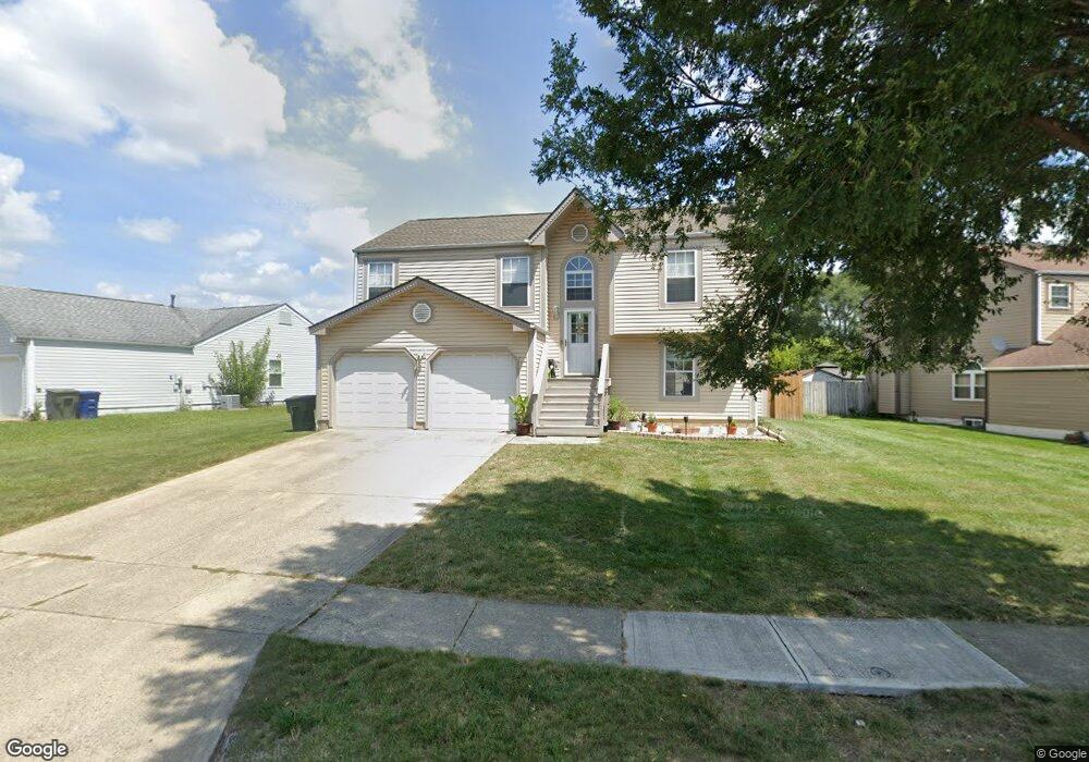
2008 Big Tree Dr Columbus, OH 43223
Estimated Value: $249,367 - $299,000
4
Beds
2
Baths
1,708
Sq Ft
$156/Sq Ft
Est. Value
About This Home
This home is located at 2008 Big Tree Dr, Columbus, OH 43223 and is currently estimated at $265,842, approximately $155 per square foot. 2008 Big Tree Dr is a home located in Franklin County with nearby schools including Finland Elementary School, Franklin Woods Intermediate School, and Finland Middle School.
Ownership History
Date
Name
Owned For
Owner Type
Purchase Details
Closed on
May 2, 2024
Sold by
Rashid Mary Dee
Bought by
Rashid Mary Dee and Rashid Hussein
Current Estimated Value
Purchase Details
Closed on
Jun 13, 1995
Sold by
Maronda Homes Of Inc
Bought by
Dee Samnang Mam and Dee Mary
Home Financials for this Owner
Home Financials are based on the most recent Mortgage that was taken out on this home.
Original Mortgage
$78,939
Interest Rate
8.26%
Mortgage Type
FHA
Create a Home Valuation Report for This Property
The Home Valuation Report is an in-depth analysis detailing your home's value as well as a comparison with similar homes in the area
Home Values in the Area
Average Home Value in this Area
Purchase History
| Date | Buyer | Sale Price | Title Company |
|---|---|---|---|
| Rashid Mary Dee | -- | None Listed On Document | |
| Dee Samnang Mam | $84,705 | -- |
Source: Public Records
Mortgage History
| Date | Status | Borrower | Loan Amount |
|---|---|---|---|
| Previous Owner | Dee Samnang Mam | $78,939 |
Source: Public Records
Tax History
| Year | Tax Paid | Tax Assessment Tax Assessment Total Assessment is a certain percentage of the fair market value that is determined by local assessors to be the total taxable value of land and additions on the property. | Land | Improvement |
|---|---|---|---|---|
| 2025 | $2,822 | $77,390 | $19,430 | $57,960 |
| 2024 | $2,822 | $77,390 | $19,430 | $57,960 |
| 2023 | $2,772 | $77,385 | $19,425 | $57,960 |
| 2022 | $2,530 | $51,840 | $8,750 | $43,090 |
| 2021 | $2,581 | $51,840 | $8,750 | $43,090 |
| 2020 | $2,493 | $50,370 | $8,750 | $41,620 |
| 2019 | $2,278 | $40,600 | $7,000 | $33,600 |
| 2018 | $2,237 | $40,600 | $7,000 | $33,600 |
| 2017 | $2,257 | $40,600 | $7,000 | $33,600 |
| 2016 | $2,207 | $36,480 | $6,200 | $30,280 |
| 2015 | $2,207 | $36,480 | $6,200 | $30,280 |
| 2014 | $2,209 | $36,480 | $6,200 | $30,280 |
| 2013 | $1,152 | $38,360 | $6,510 | $31,850 |
Source: Public Records
Map
Nearby Homes
- 1372 Stanwix Ct
- 1543 Red Leaf Ln
- 2210 October Ridge Dr
- 2072 Asher Ct
- 1640 Butterfly Ct
- 1834 Saint Lawrence Dr
- 1521 October Ridge Ct
- 1696 Marsdale Ave
- 1625 Eastfield Dr N
- 1657 Eastbrook Dr S
- 0 S Central Ave
- 1208 Woodbrook Ln Unit 307
- 1295 Woodbrook Ln Unit 223
- 1122 Harrisburg Pike
- 2180 Eakin Rd
- 2375 Woodbrook Cir S Unit 167
- 2341 Woodbrook Cir N Unit 98
- 2336 Woodbrook Cir N Unit 92 B
- 2348 Woodbrook Cir N Unit F
- 1657 Hopkins Ave
- 2000 Big Tree Dr
- 2016 Big Tree Dr
- 1458 Ellicot Ct
- 1992 Big Tree Dr
- 1452 Ellicot Ct
- 2009 Big Tree Dr
- 2015 Big Tree Dr
- 1998 Little Water Dr
- 2021 Big Tree Dr
- 1461 Tall Pine Ct
- 2042 Big Tree Dr
- 1459 Ellicot Ct
- 1467 Tall Pine Ct
- 1455 Tall Pine Ct
- 1446 Ellicot Ct
- 1990 Little Water Dr
- 2027 Big Tree Dr
- 1449 Tall Pine Ct
- 1999 Little Water Dr
- 1443 Tall Pine Ct
Your Personal Tour Guide
Ask me questions while you tour the home.