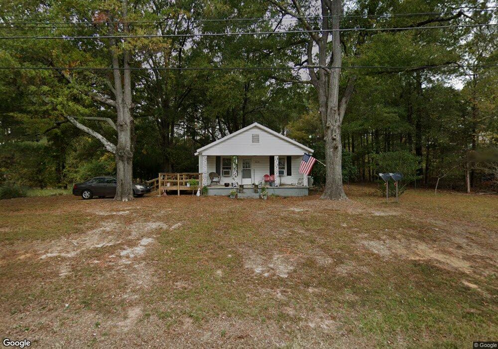
2008 Doc Nichols Rd Durham, NC 27703
Eastern Durham NeighborhoodEstimated Value: $213,581 - $451,000
2
Beds
1
Bath
840
Sq Ft
$385/Sq Ft
Est. Value
About This Home
This home is located at 2008 Doc Nichols Rd, Durham, NC 27703 and is currently estimated at $323,395, approximately $384 per square foot. 2008 Doc Nichols Rd is a home located in Durham County with nearby schools including Spring Valley Elementary School, John W Neal Middle School, and Southern School of Energy & Sustainability.
Ownership History
Date
Name
Owned For
Owner Type
Purchase Details
Closed on
Sep 21, 2023
Sold by
Brown Samuel C and Brown Bonnie F
Bought by
Brown Revocable Living Trust and Brown
Current Estimated Value
Purchase Details
Closed on
Sep 25, 2000
Sold by
Ferrell James W and Ferrell Christine
Bought by
Brown Bonnie
Create a Home Valuation Report for This Property
The Home Valuation Report is an in-depth analysis detailing your home's value as well as a comparison with similar homes in the area
Home Values in the Area
Average Home Value in this Area
Purchase History
| Date | Buyer | Sale Price | Title Company |
|---|---|---|---|
| Brown Revocable Living Trust | -- | None Listed On Document | |
| Brown Revocable Living Trust | -- | None Listed On Document | |
| Brown Bonnie | -- | -- |
Source: Public Records
Tax History Compared to Growth
Tax History
| Year | Tax Paid | Tax Assessment Tax Assessment Total Assessment is a certain percentage of the fair market value that is determined by local assessors to be the total taxable value of land and additions on the property. | Land | Improvement |
|---|---|---|---|---|
| 2025 | $1,744 | $230,188 | $133,875 | $96,313 |
| 2024 | $1,202 | $102,513 | $60,850 | $41,663 |
| 2023 | $1,153 | $102,513 | $60,850 | $41,663 |
| 2022 | $1,112 | $102,513 | $60,850 | $41,663 |
| 2021 | $899 | $102,513 | $60,850 | $41,663 |
| 2020 | $879 | $102,513 | $60,850 | $41,663 |
| 2019 | $868 | $102,513 | $60,850 | $41,663 |
| 2018 | $894 | $96,887 | $44,250 | $52,637 |
| 2017 | $865 | $96,887 | $44,250 | $52,637 |
| 2016 | $839 | $96,887 | $44,250 | $52,637 |
| 2015 | $646 | $54,970 | $26,852 | $28,118 |
| 2014 | -- | $54,970 | $26,852 | $28,118 |
Source: Public Records
Map
Nearby Homes
- 2000 Grimsby Ct Unit Lot 41
- 2000 Grimsby Ct
- 702 Blackpool Dr
- 704 Blackpool Dr
- 710 Blackpool Dr
- 712 Blackpool Dr
- 1116 Salford Ct Unit *Lot 142
- 708 Blackpool Dr
- 702 Blackpool Dr Unit *Lot 117
- 710 Blackpool Dr Unit *Lot 121
- 708 Blackpool Dr Unit *Lot 120
- 1132 Salford Ct
- 1132 Salford Ct Unit *Lot 146
- 1128 Salford Ct Unit *Lot 145
- 1128 Salford Ct
- 1136 Salford Ct Unit *Lot 147
- 1136 Salford Ct
- 501 Brittany Ct
- Eno Plan at Tredenham
- Shepard Plan at Tredenham
- 1116 Salford Ct
- 2005 Doc Nichols Rd
- 2009 Doc Nichols Rd
- 2015 Doc Nichols Rd
- 2010 Doc Nichols Rd
- 2021 Doc Nichols Rd
- 531 Brittany Ct
- 3000 Doc Nichols Rd
- 606 Brittany Ct
- 602 Brittany Ct
- 5518 Leesville Rd
- 906 Montague Ave
- 521 Brittany
- 2012 Doc Nichols Rd
- 507 Brittany Ct
- 5607 Leesville Rd
- 535 Brittany Ct
- 5600 Leesville Rd
- 5417 Leesville Rd
- 600 Brittany Ct