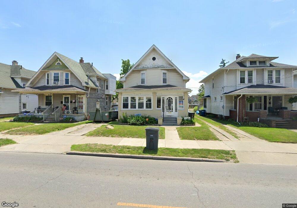
2009 Airport Hwy Toledo, OH 43609
Southside NeighborhoodEstimated Value: $82,000 - $100,000
2
Beds
2
Baths
1,318
Sq Ft
$68/Sq Ft
Est. Value
About This Home
This home is located at 2009 Airport Hwy, Toledo, OH 43609 and is currently estimated at $89,411, approximately $67 per square foot. 2009 Airport Hwy is a home located in Lucas County with nearby schools including Burroughs Elementary School, Bowsher High School, and Explorers Academy of Science and Technology.
Ownership History
Date
Name
Owned For
Owner Type
Purchase Details
Closed on
Feb 9, 2015
Sold by
Fifer Randy S and Fifer Marcia L
Bought by
Fifer Investments Llc
Current Estimated Value
Purchase Details
Closed on
May 24, 2011
Sold by
Fifer Randy S and Fifer Marcia L
Bought by
Fifer Randy S
Purchase Details
Closed on
Mar 16, 1989
Sold by
Lanning Sylvester C
Create a Home Valuation Report for This Property
The Home Valuation Report is an in-depth analysis detailing your home's value as well as a comparison with similar homes in the area
Home Values in the Area
Average Home Value in this Area
Purchase History
| Date | Buyer | Sale Price | Title Company |
|---|---|---|---|
| Fifer Investments Llc | -- | None Available | |
| Fifer Randy S | -- | Attorney | |
| -- | $19,000 | -- |
Source: Public Records
Tax History Compared to Growth
Tax History
| Year | Tax Paid | Tax Assessment Tax Assessment Total Assessment is a certain percentage of the fair market value that is determined by local assessors to be the total taxable value of land and additions on the property. | Land | Improvement |
|---|---|---|---|---|
| 2024 | $1,587 | $22,505 | $4,865 | $17,640 |
| 2023 | $1,413 | $16,520 | $5,145 | $11,375 |
| 2022 | $1,198 | $16,520 | $5,145 | $11,375 |
| 2021 | $1,194 | $16,520 | $5,145 | $11,375 |
| 2020 | $1,148 | $13,615 | $4,235 | $9,380 |
| 2019 | $1,108 | $13,615 | $4,235 | $9,380 |
| 2018 | $1,145 | $13,615 | $4,235 | $9,380 |
| 2017 | $2,669 | $14,630 | $3,360 | $11,270 |
| 2016 | $1,225 | $41,800 | $9,600 | $32,200 |
| 2015 | $1,183 | $41,800 | $9,600 | $32,200 |
| 2014 | $946 | $14,630 | $3,360 | $11,270 |
| 2013 | $946 | $14,630 | $3,360 | $11,270 |
Source: Public Records
Map
Nearby Homes
- 440 Somerset St
- 321 Mayberry St
- 2126 Airport Hwy
- 221 Somerset St
- 226 Somerset St
- 224 S Fearing Blvd
- 304 Mayberry St
- 531 Shasta Dr
- 142 S Detroit Ave
- 512 Woodsdale Ave
- 1754 Finch St
- 1777 South Ave
- 140 Whiting Ave
- 649 Wright Ave
- 705 Wright Ave
- 556 Apple Ave
- 323 Champion St
- 713 Geneva Ave
- 1587 Colton St
- 731 Geneva Ave
- 2005 Airport Hwy
- 2013 Airport Hwy
- 2015 Airport Hwy
- 352 S Detroit Ave
- 356 S Detroit Ave
- 2010 Airport Hwy
- 362 S Detroit Ave
- 2014 Airport Hwy
- 2008 Airport Hwy
- 344 S Detroit Ave
- 2018 Airport Hwy
- 2002 Airport Hwy
- 364 S Detroit Ave
- 431 Somerset St
- 2022 Airport Hwy
- 368 S Detroit Ave
- 2028 Airport Hwy
- 435 Somerset St
- 1938 Airport Hwy
- 372 S Detroit Ave