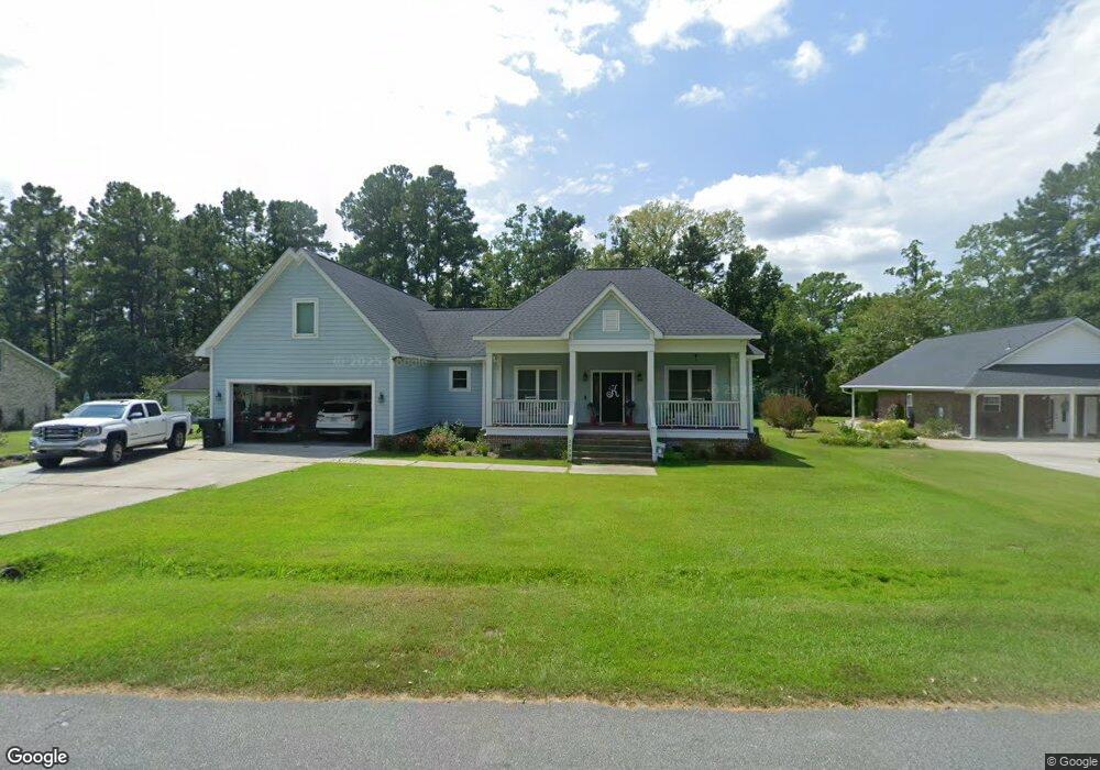
2009 Albert Storm Ave Moncks Corner, SC 29461
Estimated Value: $469,048 - $545,000
Studio
--
Bath
2,417
Sq Ft
$210/Sq Ft
Est. Value
About This Home
This home is located at 2009 Albert Storm Ave, Moncks Corner, SC 29461 and is currently estimated at $508,512, approximately $210 per square foot. 2009 Albert Storm Ave is a home with nearby schools including Foxbank Elementary School, Berkeley Middle School, and Berkeley High School.
Ownership History
Date
Name
Owned For
Owner Type
Purchase Details
Closed on
Jun 12, 2017
Sold by
Martin Christopher C
Bought by
Kitts Jonathan D
Current Estimated Value
Home Financials for this Owner
Home Financials are based on the most recent Mortgage that was taken out on this home.
Original Mortgage
$249,750
Outstanding Balance
$207,626
Interest Rate
4%
Mortgage Type
Construction
Estimated Equity
$300,886
Purchase Details
Closed on
Mar 2, 2017
Sold by
Martin Charles H and Martin Linda J
Bought by
Martin Christopher C
Purchase Details
Closed on
Dec 28, 2004
Sold by
Haines Steven C and Haines Kimberly A
Bought by
Martin Charles H and Martin Linda J
Create a Home Valuation Report for This Property
The Home Valuation Report is an in-depth analysis detailing your home's value as well as a comparison with similar homes in the area
Purchase History
| Date | Buyer | Sale Price | Title Company |
|---|---|---|---|
| Kitts Jonathan D | $42,500 | None Available | |
| Martin Christopher C | -- | None Available | |
| Martin Charles H | $28,000 | -- |
Source: Public Records
Mortgage History
| Date | Status | Borrower | Loan Amount |
|---|---|---|---|
| Open | Kitts Jonathan D | $249,750 |
Source: Public Records
Tax History
| Year | Tax Paid | Tax Assessment Tax Assessment Total Assessment is a certain percentage of the fair market value that is determined by local assessors to be the total taxable value of land and additions on the property. | Land | Improvement |
|---|---|---|---|---|
| 2025 | $1,453 | $299,740 | $44,835 | $254,905 |
| 2024 | $1,374 | $11,989 | $1,793 | $10,196 |
| 2023 | $1,374 | $11,989 | $1,793 | $10,196 |
| 2022 | $1,331 | $9,984 | $1,800 | $8,184 |
| 2021 | $1,363 | $9,980 | $1,800 | $8,184 |
| 2020 | $1,379 | $9,984 | $1,800 | $8,184 |
| 2019 | $1,370 | $9,984 | $1,800 | $8,184 |
| 2018 | $697 | $2,400 | $2,400 | $0 |
| 2017 | $163 | $1,217 | $1,217 | $0 |
| 2016 | $167 | $1,220 | $1,220 | $0 |
| 2015 | $154 | $1,220 | $1,220 | $0 |
| 2014 | $153 | $1,220 | $1,220 | $0 |
| 2013 | -- | $1,220 | $1,220 | $0 |
Source: Public Records
Map
Nearby Homes
- 2015 Albert Storm Ave
- 0 Point Comfort Rd Unit 24030382
- 0 Point Comfort Rd Unit 24030383
- 0 Point Comfort Rd Unit 24028043
- 1811 Teal Rd
- 1822 Mallard Cir
- 1629 Pimlico Blvd
- 1004 Magnolia Ln
- 214 Osprey Dr
- 00 Gertie Ln
- 134 Gertie Ln
- 0 Gertie Ln
- 266 Oglethorpe Cir
- 153 Willow Brook Way
- 223 Everwood Ct
- 258 Truth Way
- 415 Camellia Bloom Dr
- 415 Black Horse Rd
- 143 Dixon Ln
- 601 Winter Wren Way
- 2011 Albert Storm Ave
- 2007 Albert Storm Ave
- 2008 Albert Storm Ave
- 2013 Albert Storm Ave
- 2010 Albert Storm Ave
- 2012 Albert Storm Ave
- 2017 Albert Storm Ave
- 2001 Albert Storm Ave
- 2015 Rock Fish Rd
- 1801 Bass Rd
- 2009 Rock Fish Rd
- 2011 Rock Fish Rd
- 1803 Bass Rd
- 2005 Rock Fish Rd
- 2013 Rock Fish Rd
- 1907 Albert Storm Ave
- 2003 Rock Fish Rd
- 2101 Albert Storm Ave
- 2018 Rock Fish Rd
- 1702 Catfish Rd
Your Personal Tour Guide
Ask me questions while you tour the home.