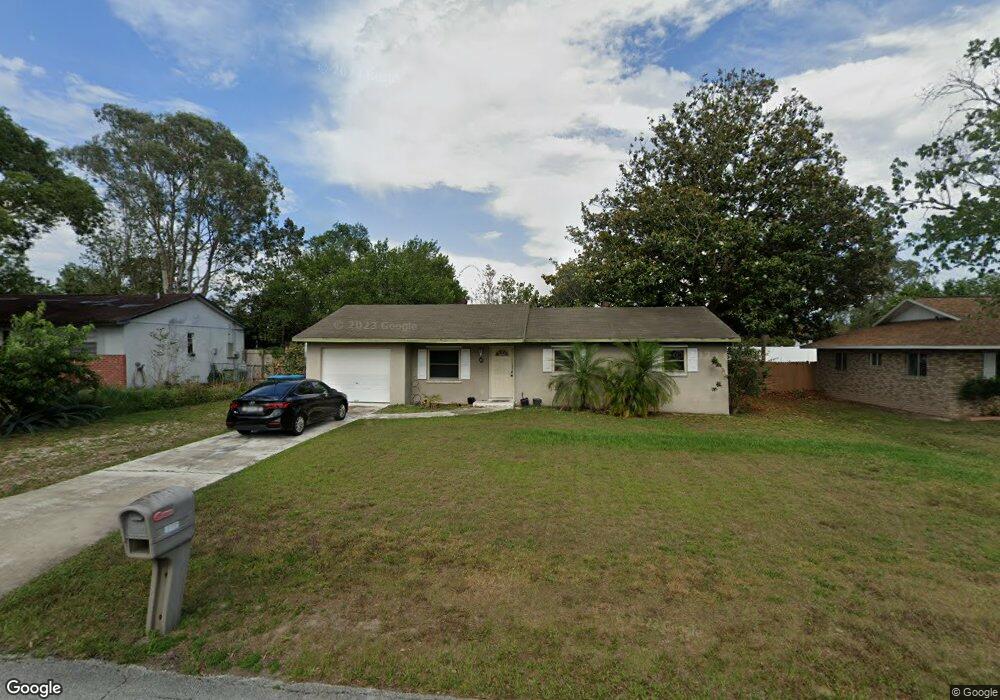
2009 Dalton Ave Deltona, FL 32725
Estimated Value: $226,702 - $257,000
3
Beds
2
Baths
1,649
Sq Ft
$148/Sq Ft
Est. Value
About This Home
This home is located at 2009 Dalton Ave, Deltona, FL 32725 and is currently estimated at $243,926, approximately $147 per square foot. 2009 Dalton Ave is a home located in Volusia County with nearby schools including Spirit Elementary School, Deltona Middle School, and Deltona High School.
Ownership History
Date
Name
Owned For
Owner Type
Purchase Details
Closed on
Dec 5, 2012
Sold by
Federal National Mortgage Association
Bought by
Doering Donald Andrew and Doering Threasa Lynn
Current Estimated Value
Home Financials for this Owner
Home Financials are based on the most recent Mortgage that was taken out on this home.
Original Mortgage
$55,750
Outstanding Balance
$38,771
Interest Rate
3.45%
Mortgage Type
Purchase Money Mortgage
Estimated Equity
$205,155
Purchase Details
Closed on
Jun 19, 2012
Sold by
Petticord Michelle and Petticord Herbert C
Bought by
Federal National Mortgage Association
Purchase Details
Closed on
Aug 18, 2006
Sold by
Giordano Michael
Bought by
Petticord Michelle
Home Financials for this Owner
Home Financials are based on the most recent Mortgage that was taken out on this home.
Original Mortgage
$128,160
Interest Rate
6.67%
Mortgage Type
Purchase Money Mortgage
Purchase Details
Closed on
Mar 12, 2004
Sold by
Walker and Tudhope
Bought by
Giordano Michael
Home Financials for this Owner
Home Financials are based on the most recent Mortgage that was taken out on this home.
Original Mortgage
$81,500
Interest Rate
7.05%
Mortgage Type
Purchase Money Mortgage
Purchase Details
Closed on
Jan 24, 2003
Sold by
Blair Kathleen
Bought by
Walker & Tudhope Tr
Purchase Details
Closed on
Oct 11, 2000
Sold by
Giordano Michael S and Giordano Dorothy R
Bought by
Blair Kathleen
Home Financials for this Owner
Home Financials are based on the most recent Mortgage that was taken out on this home.
Original Mortgage
$68,400
Interest Rate
7.96%
Purchase Details
Closed on
Jul 22, 1998
Sold by
Giordano Dorothy R
Bought by
Giordano Dorothy R and Giordano Michael S
Purchase Details
Closed on
Apr 24, 1998
Sold by
Giordano Dorothy R
Bought by
Giordano Dorothy R and Giordano Michael S
Purchase Details
Closed on
Aug 6, 1997
Sold by
Beckman Michael F and Hill David P
Bought by
Sun & Sand Prop Inc
Purchase Details
Closed on
Jun 9, 1997
Sold by
Clerk Circuit Court
Bought by
Hill David P and Beckman Michael F
Purchase Details
Closed on
Mar 15, 1988
Bought by
Doering Donald Andrew
Create a Home Valuation Report for This Property
The Home Valuation Report is an in-depth analysis detailing your home's value as well as a comparison with similar homes in the area
Home Values in the Area
Average Home Value in this Area
Purchase History
| Date | Buyer | Sale Price | Title Company |
|---|---|---|---|
| Doering Donald Andrew | $55,750 | Oak Ridge Title Inc | |
| Federal National Mortgage Association | -- | None Available | |
| Petticord Michelle | $160,200 | Esquire Title Services Inc | |
| Giordano Michael | -- | -- | |
| Walker & Tudhope Tr | $74,000 | -- | |
| Blair Kathleen | $72,000 | -- | |
| Giordano Dorothy R | -- | -- | |
| Giordano Dorothy R | -- | -- | |
| Sun & Sand Prop Inc | $39,500 | -- | |
| Hill David P | $38,200 | -- | |
| Doering Donald Andrew | $43,000 | -- |
Source: Public Records
Mortgage History
| Date | Status | Borrower | Loan Amount |
|---|---|---|---|
| Open | Doering Donald Andrew | $55,750 | |
| Previous Owner | Petticord Michelle | $128,160 | |
| Previous Owner | Giordano Michael | $81,500 | |
| Previous Owner | Blair Kathleen | $68,400 |
Source: Public Records
Tax History Compared to Growth
Tax History
| Year | Tax Paid | Tax Assessment Tax Assessment Total Assessment is a certain percentage of the fair market value that is determined by local assessors to be the total taxable value of land and additions on the property. | Land | Improvement |
|---|---|---|---|---|
| 2025 | $986 | $81,065 | -- | -- |
| 2024 | $986 | $78,781 | -- | -- |
| 2023 | $986 | $76,487 | $0 | $0 |
| 2022 | $968 | $74,259 | $0 | $0 |
| 2021 | $999 | $72,096 | $0 | $0 |
| 2020 | $997 | $71,101 | $0 | $0 |
| 2019 | $1,016 | $69,502 | $0 | $0 |
| 2018 | $1,006 | $68,206 | $0 | $0 |
| 2017 | $994 | $66,803 | $0 | $0 |
| 2016 | $982 | $65,429 | $0 | $0 |
| 2015 | $1,688 | $58,966 | $0 | $0 |
| 2014 | $1,558 | $54,750 | $0 | $0 |
Source: Public Records
Map
Nearby Homes
- 1025 Sullivan St
- 1030 Blue Horizon Dr
- 1019 Sullivan St
- 1022 Blue Horizon Dr
- 1108 Sherbrook Dr
- 1991 Tilburg Ave
- 1940 Viking Ave
- 918 N Atmore Cir
- 1936 S Old Mill Dr
- 917 Swallow St
- 1940 S Old Mill Dr
- 1170 Elkcam Blvd Unit 100
- 1171 Elkcam Blvd
- 2091 Oldham Ave
- 2030 Deborah Terrace
- 2040 Deborah Terrace
- 908 Vercelli St
- 2050 Deborah Terrace
- 889 Swallow St
- 0 Elkcam Blvd Unit MFRV4942623
- 2013 Dalton Ave
- 2014 Dearing Ave
- 2008 Dearing Ave
- 2020 Dearing Ave
- 2017 Dalton Ave
- 2001 Dalton Ave
- 2014 Dalton Ave
- 1048 Sullivan St
- 2018 Dalton Ave
- 2026 Dearing Ave
- 2008 Dalton Ave
- 2022 Dalton Ave
- 2021 Dalton Ave
- 2002 Dalton Ave
- 2032 Dearing Ave
- 2026 Dalton Ave
- 2019 Dearing Ave
- 2025 Dalton Ave
- 2007 Dearing Ave