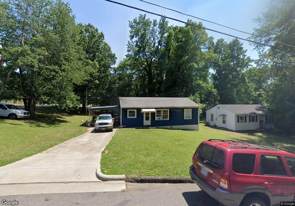
2009 Scott St Statesville, NC 28677
Estimated Value: $63,000 - $163,000
3
Beds
1
Bath
936
Sq Ft
$124/Sq Ft
Est. Value
About This Home
This home is located at 2009 Scott St, Statesville, NC 28677 and is currently estimated at $115,694, approximately $123 per square foot. 2009 Scott St is a home located in Iredell County with nearby schools including N.B. Mills Elementary School, West Iredell Middle School, and West Iredell High School.
Ownership History
Date
Name
Owned For
Owner Type
Purchase Details
Closed on
Feb 1, 2021
Sold by
Bradford Teejay W
Bought by
Schofield Landry
Current Estimated Value
Purchase Details
Closed on
Apr 27, 2011
Sold by
Messick Richard Keith and Messick Debbie H
Bought by
Bradford Teejay W
Home Financials for this Owner
Home Financials are based on the most recent Mortgage that was taken out on this home.
Original Mortgage
$5,000
Interest Rate
4.74%
Mortgage Type
Purchase Money Mortgage
Purchase Details
Closed on
Oct 4, 2006
Sold by
Messick Peggy Claywell
Bought by
Messick William Kent and Messick Richard Keith
Create a Home Valuation Report for This Property
The Home Valuation Report is an in-depth analysis detailing your home's value as well as a comparison with similar homes in the area
Home Values in the Area
Average Home Value in this Area
Purchase History
| Date | Buyer | Sale Price | Title Company |
|---|---|---|---|
| Schofield Landry | $25,000 | None Available | |
| Bradford Teejay W | $16,000 | None Available | |
| Messick William Kent | -- | Chicago Title Insurance Co |
Source: Public Records
Mortgage History
| Date | Status | Borrower | Loan Amount |
|---|---|---|---|
| Previous Owner | Bradford Teejay W | $5,000 |
Source: Public Records
Tax History Compared to Growth
Tax History
| Year | Tax Paid | Tax Assessment Tax Assessment Total Assessment is a certain percentage of the fair market value that is determined by local assessors to be the total taxable value of land and additions on the property. | Land | Improvement |
|---|---|---|---|---|
| 2024 | $455 | $41,380 | $12,000 | $29,380 |
| 2023 | $455 | $41,380 | $12,000 | $29,380 |
| 2022 | $489 | $36,270 | $12,000 | $24,270 |
| 2021 | $545 | $36,270 | $12,000 | $24,270 |
| 2020 | $545 | $36,270 | $12,000 | $24,270 |
| 2019 | $541 | $36,270 | $12,000 | $24,270 |
| 2018 | $538 | $38,640 | $13,070 | $25,570 |
| 2017 | $531 | $38,640 | $13,070 | $25,570 |
| 2016 | $531 | $38,640 | $13,070 | $25,570 |
| 2015 | $395 | $38,640 | $13,070 | $25,570 |
| 2014 | $478 | $50,510 | $21,780 | $28,730 |
Source: Public Records
Map
Nearby Homes
- 1713 Forest Dr
- 1716 Younger Ave
- 2321 Cline St
- 1709 Younger Ave
- 50 S Miller Ave Unit A
- 50 S Miller Ave Unit B
- 127 Bristol Rd
- 328 N Miller Ave
- 3 Williams Ave
- 417 Central Dr
- 407 Central Dr
- 1309 Williams Rd
- 2607 Moss Rd
- 1120 Rita Ave
- 812 Candy Dr
- 818 Candy Dr
- 1129 Rita Ave
- Robie Plan at Bristol Terrace
- Penwell Plan at Bristol Terrace
- Hayden Plan at Bristol Terrace
- 2013 Scott St
- 516 Hawthorne Dr
- 2017 Scott St
- 2021 Newton Dr
- 2025 Newton Dr
- 2121 Scott St
- 2010 Gagner St
- 2000 Gagner St
- 2002 Gagner St
- 2012 Gagner St
- 511 Hawthorne Dr
- 2125 Scott St
- 503 Hawthorne Dr
- 2028 Gagner St
- 2020 Newton Dr
- 2030 Gagner St
- 2011 Gagner St
- 1907 Newton Dr Unit L2-6 L1 21
- 2015 Gagner St
- 2032 Gagner St