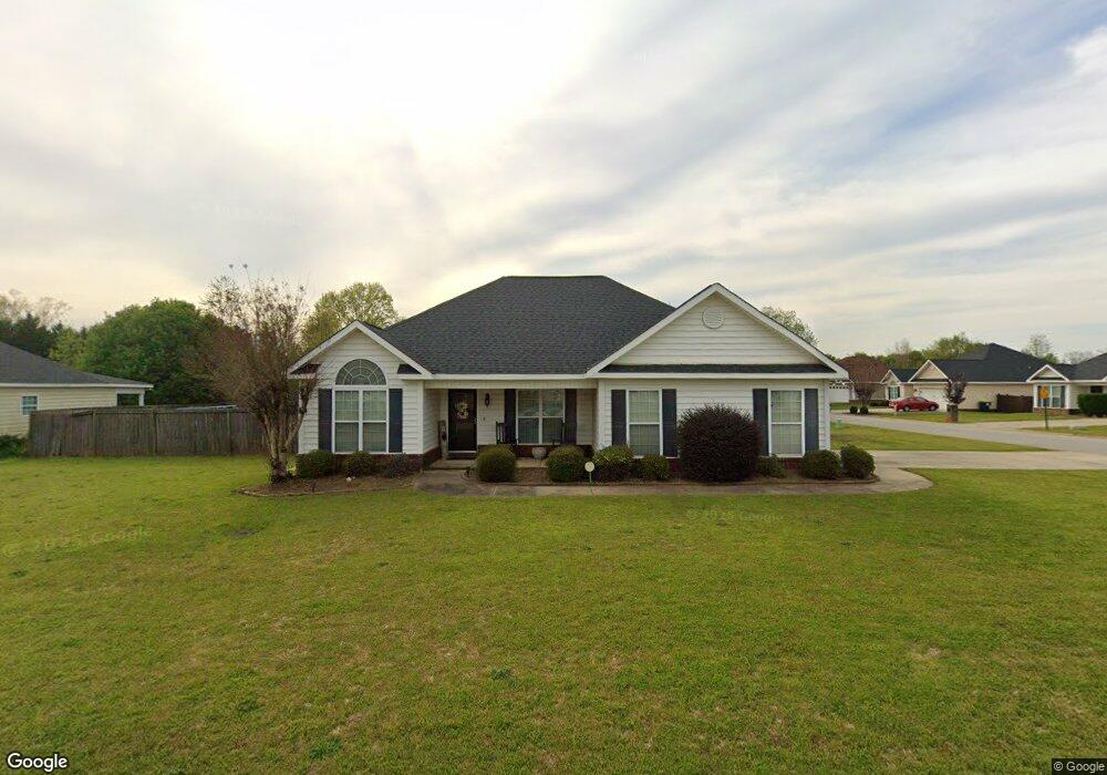
201 Apple Ct Warner Robins, GA 31088
Estimated Value: $231,604 - $245,000
3
Beds
2
Baths
1,440
Sq Ft
$166/Sq Ft
Est. Value
About This Home
This home is located at 201 Apple Ct, Warner Robins, GA 31088 and is currently estimated at $238,401, approximately $165 per square foot. 201 Apple Ct is a home located in Houston County with nearby schools including David A. Perdue Primary School, David A. Perdue Elementary School, and Feagin Mill Middle School.
Ownership History
Date
Name
Owned For
Owner Type
Purchase Details
Closed on
Sep 15, 2008
Sold by
Middleton Ryan M and Middleton Laura K
Bought by
Benson Renita
Current Estimated Value
Home Financials for this Owner
Home Financials are based on the most recent Mortgage that was taken out on this home.
Original Mortgage
$118,665
Outstanding Balance
$78,815
Interest Rate
6.49%
Mortgage Type
FHA
Estimated Equity
$159,586
Purchase Details
Closed on
Jan 20, 2005
Sold by
Middleton Ryan M
Bought by
Middleton Ryan M and Middleton Laura K
Purchase Details
Closed on
Sep 27, 2004
Sold by
Olf Bryan D and Olf Kimberly J
Bought by
Middleton Ryan M
Purchase Details
Closed on
Jun 10, 2004
Sold by
Sun King Inc
Bought by
Olf Bryan D and Olf Kimberly J
Create a Home Valuation Report for This Property
The Home Valuation Report is an in-depth analysis detailing your home's value as well as a comparison with similar homes in the area
Home Values in the Area
Average Home Value in this Area
Purchase History
| Date | Buyer | Sale Price | Title Company |
|---|---|---|---|
| Benson Renita | $128,500 | None Available | |
| Middleton Ryan M | -- | None Available | |
| Middleton Ryan M | $119,000 | -- | |
| Olf Bryan D | $23,500 | -- |
Source: Public Records
Mortgage History
| Date | Status | Borrower | Loan Amount |
|---|---|---|---|
| Open | Benson Renita | $118,665 | |
| Closed | Benson Renita | $10,000 |
Source: Public Records
Tax History Compared to Growth
Tax History
| Year | Tax Paid | Tax Assessment Tax Assessment Total Assessment is a certain percentage of the fair market value that is determined by local assessors to be the total taxable value of land and additions on the property. | Land | Improvement |
|---|---|---|---|---|
| 2024 | $2,532 | $78,760 | $9,600 | $69,160 |
| 2023 | $2,158 | $66,840 | $8,800 | $58,040 |
| 2022 | $1,375 | $61,800 | $8,800 | $53,000 |
| 2021 | $1,145 | $51,520 | $8,800 | $42,720 |
| 2020 | $1,033 | $46,480 | $8,800 | $37,680 |
| 2019 | $1,033 | $46,480 | $8,800 | $37,680 |
| 2018 | $1,033 | $46,480 | $8,800 | $37,680 |
| 2017 | $1,034 | $46,480 | $8,800 | $37,680 |
| 2016 | $1,036 | $46,480 | $8,800 | $37,680 |
| 2015 | -- | $46,480 | $8,800 | $37,680 |
| 2014 | $497 | $46,480 | $8,800 | $37,680 |
| 2013 | $497 | $46,480 | $8,800 | $37,680 |
Source: Public Records
Map
Nearby Homes
- 604 Twelve Oaks Dr
- 201 Melvina Dr
- 105 Green Meadow Dr
- 319 Tyson Glen Dr
- 204 Lovorn Cir
- 1148 Thornblade Dr
- 1613 Sweetwater Dr
- 318 Lovorn Cir
- 112 Ballyhara
- 414 Bella Notte Cir
- 414 Bella Notte Cir Unit 23A
- 416 Bella Notte Cir
- 416 Bella Notte Cir Unit 22A
- 418 Bella Notte Cir Unit 21A
- 115 Settlers Trail
- 900 Bay Laurel Cir
- 105 Liam Ct
- 0 Apple Ct Unit 8487677
- 203 Apple Ct
- 200 Apple Ct
- 202 Apple Ct
- 205 Apple Ct
- 106 Apple Ct
- 204 Apple Ct
- 110 Liam Ct
- 103 Liam Ct
- 108 Liam Ct
- 206 Apple Ct
- 207 Apple Ct
- 0 Liam Ct Unit 8618075
- 0 Liam Ct Unit 8264023
- 102 Apple Ct
- 106 Liam Ct
- 208 Apple Ct
- 203 Allington Walk
- 201 Allington Walk Unit 117