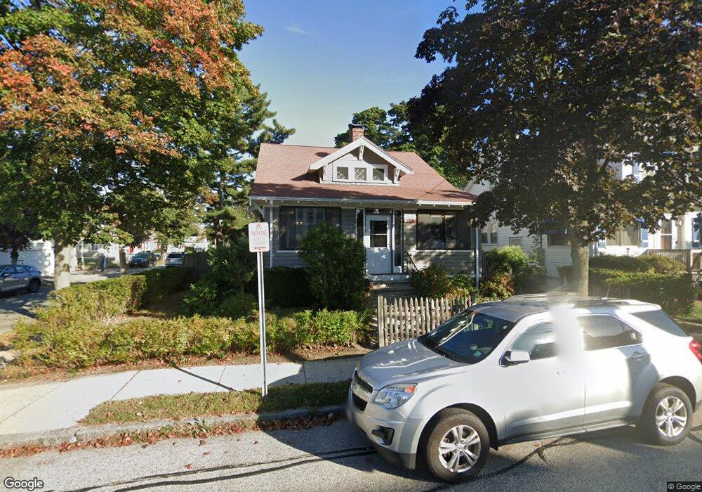
201 Beach St Quincy, MA 02170
Wollaston NeighborhoodEstimated Value: $726,000 - $785,000
3
Beds
2
Baths
1,438
Sq Ft
$522/Sq Ft
Est. Value
About This Home
This home is located at 201 Beach St, Quincy, MA 02170 and is currently estimated at $750,534, approximately $521 per square foot. 201 Beach St is a home located in Norfolk County with nearby schools including Beechwood Knoll Elementary School, Atlantic Middle School, and North Quincy High School.
Ownership History
Date
Name
Owned For
Owner Type
Purchase Details
Closed on
Aug 15, 2023
Sold by
Forbes Peter W and Forbes Susan G
Bought by
Forbes Ret and Forbes
Current Estimated Value
Purchase Details
Closed on
Jul 31, 1995
Sold by
Corbin Richard J and Corbin Carmela A
Bought by
Forbes Peter W and Forbes Susan G
Home Financials for this Owner
Home Financials are based on the most recent Mortgage that was taken out on this home.
Original Mortgage
$123,250
Interest Rate
7.56%
Mortgage Type
Purchase Money Mortgage
Create a Home Valuation Report for This Property
The Home Valuation Report is an in-depth analysis detailing your home's value as well as a comparison with similar homes in the area
Home Values in the Area
Average Home Value in this Area
Purchase History
| Date | Buyer | Sale Price | Title Company |
|---|---|---|---|
| Forbes Ret | -- | None Available | |
| Forbes Peter W | $145,000 | -- | |
| Forbes Peter W | $145,000 | -- |
Source: Public Records
Mortgage History
| Date | Status | Borrower | Loan Amount |
|---|---|---|---|
| Previous Owner | Forbes Peter W | $118,000 | |
| Previous Owner | Forbes Peter W | $30,000 | |
| Previous Owner | Forbes Peter W | $123,250 |
Source: Public Records
Tax History
| Year | Tax Paid | Tax Assessment Tax Assessment Total Assessment is a certain percentage of the fair market value that is determined by local assessors to be the total taxable value of land and additions on the property. | Land | Improvement |
|---|---|---|---|---|
| 2025 | $7,318 | $634,700 | $319,000 | $315,700 |
| 2024 | $7,123 | $632,000 | $319,000 | $313,000 |
| 2023 | $6,639 | $596,500 | $303,800 | $292,700 |
| 2022 | $6,321 | $527,600 | $243,000 | $284,600 |
| 2021 | $5,909 | $486,700 | $243,000 | $243,700 |
| 2020 | $5,994 | $482,200 | $243,000 | $239,200 |
| 2019 | $5,502 | $438,400 | $227,100 | $211,300 |
| 2018 | $5,464 | $409,600 | $206,500 | $203,100 |
| 2017 | $5,672 | $400,300 | $206,500 | $193,800 |
| 2016 | $5,425 | $377,800 | $187,700 | $190,100 |
| 2015 | $4,860 | $332,900 | $170,600 | $162,300 |
| 2014 | $4,528 | $304,700 | $162,500 | $142,200 |
Source: Public Records
Map
Nearby Homes
- 11 Cleaves St
- 28 Apthorp St
- 20 Ellington Rd
- 27 Herbert Rd
- 144 Kemper St
- 10 Weston Ave Unit 322
- 85 E Squantum St Unit 10
- 267-269 Farrington St
- 22 Newton Ave
- 17 Holmes St Unit 204
- 17 Holmes St Unit 2
- 17 Holmes St Unit 1
- 297 Billings St
- 39 Fayette St Unit 403
- 201 Billings St
- 154 N Central Ave
- 115 W Squantum St Unit 517
- 115 W Squantum St Unit 811
- 915 Hancock St Unit 2
- 72 Oakland Ave
- 197 Beach St
- 64 Bromfield St
- 60 Bromfield St Unit 2
- 60 Bromfield St
- 209 Beach St
- 209 Beach St Unit 209
- 209 Beach St Unit 1
- 209 Beach St Unit 1st flr
- 193 Beach St
- 155 Cummings Ave
- 58 Bromfield St Unit 1
- 68 Bromfield St
- 202 Beach St
- 56 Bromfield St
- 198 Beach St
- 213 Beach St
- 196 Beach St Unit 2
- 196 Beach St
- 191 Beach St
- 72 Bromfield St
Your Personal Tour Guide
Ask me questions while you tour the home.