


201 Boundary Ave Chestertown, MD 21620
Kingstown NeighborhoodEstimated payment $2,640/month
Highlights
- Popular Property
- Home fronts navigable water
- No HOA
- Church Hill Elementary School Rated A-
- Water Access
- 2 Attached Carport Spaces
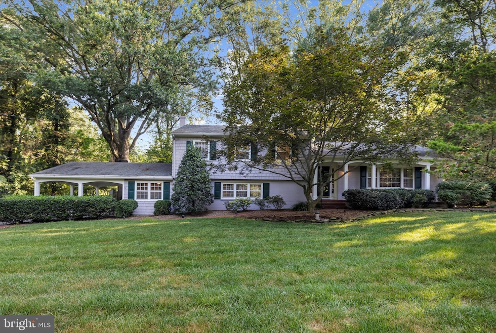
About This Home
Discover this spacious home offering 3,100 sq ft of living space on a 1⁄2 acre lot with deeded access to the Chester River. Generously sized rooms and an inviting floor plan create an ideal setting for both everyday living and entertaining. The main level bedroom features a recently remodeled bath and large walk in closet. Enjoy the natural light and tranquil views from the sunroom, perfect for relaxing year-round.
*New roof has been installed!
Listing Agent
(410) 703-3820 mcarlisle@cbchesapeake.com Coldwell Banker Chesapeake Real Estate Company License #597467 Listed on: 08/08/2025

Home Details
Home Type
- Single Family
Est. Annual Taxes
- $3,229
Year Built
- Built in 1968
Lot Details
- 0.54 Acre Lot
- Home fronts navigable water
- Property is zoned NC-20
Home Design
- Split Level Home
- Frame Construction
Interior Spaces
- 3,096 Sq Ft Home
- Property has 3 Levels
- Ceiling Fan
- Finished Basement
- Crawl Space
Bedrooms and Bathrooms
Parking
- 2 Parking Spaces
- 2 Attached Carport Spaces
- Driveway
Outdoor Features
- Water Access
- River Nearby
Utilities
- Central Air
- Back Up Electric Heat Pump System
- Electric Baseboard Heater
- Well
- Electric Water Heater
- On Site Septic
Community Details
- No Home Owners Association
- Chestertown Subdivision
Listing and Financial Details
- Assessor Parcel Number 1802000717
Map
Home Values in the Area
Average Home Value in this Area
Tax History
| Year | Tax Paid | Tax Assessment Tax Assessment Total Assessment is a certain percentage of the fair market value that is determined by local assessors to be the total taxable value of land and additions on the property. | Land | Improvement |
|---|---|---|---|---|
| 2025 | $3,078 | $370,300 | $84,500 | $285,800 |
| 2024 | $3,078 | $342,833 | $0 | $0 |
| 2023 | $2,922 | $315,367 | $0 | $0 |
| 2022 | $2,772 | $287,900 | $81,800 | $206,100 |
| 2021 | $2,182 | $282,433 | $0 | $0 |
| 2020 | $2,716 | $276,967 | $0 | $0 |
| 2019 | $2,604 | $271,500 | $71,800 | $199,700 |
| 2018 | $2,604 | $271,500 | $71,800 | $199,700 |
| 2017 | $2,839 | $271,500 | $0 | $0 |
| 2016 | -- | $289,800 | $0 | $0 |
| 2015 | $1,413 | $289,800 | $0 | $0 |
| 2014 | $1,413 | $289,800 | $0 | $0 |
Property History
| Date | Event | Price | Change | Sq Ft Price |
|---|---|---|---|---|
| 09/10/2025 09/10/25 | Price Changed | $449,000 | -4.5% | $145 / Sq Ft |
| 08/08/2025 08/08/25 | For Sale | $470,000 | -- | $152 / Sq Ft |
Purchase History
| Date | Type | Sale Price | Title Company |
|---|---|---|---|
| Deed | $165,000 | -- | |
| Deed | $84,500 | -- |
Mortgage History
| Date | Status | Loan Amount | Loan Type |
|---|---|---|---|
| Closed | $132,000 | No Value Available | |
| Previous Owner | $104,500 | No Value Available |
Source: Bright MLS
MLS Number: MDQA2014272
APN: 02-000717
Disclaimer: Certain information contained herein is derived from information provided by parties other than Homes.com. All information provided is deemed reliable, but is not guaranteed to be accurate and should be independently verified.
![]() The data relating to real estate for sale on this website appears in part through the BRIGHT Internet Data Exchange program, a voluntary cooperative exchange of property listing data between licensed real estate brokerage firms, and is provided by BRIGHT through a licensing agreement.
The data relating to real estate for sale on this website appears in part through the BRIGHT Internet Data Exchange program, a voluntary cooperative exchange of property listing data between licensed real estate brokerage firms, and is provided by BRIGHT through a licensing agreement.
Listing information is from various brokers who participate in the Bright MLS IDX program and not all listings may be visible on the site.
The property information being provided on or through the website is for the personal, non-commercial use of consumers and such information may not be used for any purpose other than to identify prospective properties consumers may be interested in purchasing.
Some properties which appear for sale on the website may no longer be available because they are for instance, under contract, sold or are no longer being offered for sale.
Property information displayed is deemed reliable but is not guaranteed.
Copyright 2025 Bright MLS, Inc.
- 136 Truslow Farm Ln
- 7989 Quaker Neck Rd
- 7961 Quaker Neck Rd
- 0 Little Harbor Way Unit 1 MDKE2004992
- 118 Little Harbor Way Unit 201
- 212 Landing Ln
- 103 Landing Ln
- 25800 Collins Ave
- 226 S Water St
- 221 Old Bridge Rd
- 206 S Water St
- 105 High St
- 7483 Shortall St
- 0 East St
- 206 Cannon St
- 7729 Country Club Ln
- 117 N Water St Unit 1A
- 117 N Water St Unit 2A
- 225 Duke of Kent St
- 209 Rivershore Rd
- 104 Maple Ave
- 128 N Queen St Unit 4
- 101 Morgnec Rd
- 24906 Lambs Meadow Rd
- 10743 Millbrook Dr
- 300 Oak St
- 5810 Clam Cove
- 126 Price St
- 108 Little Kidwell Ave Unit A
- 14500 Cherry Ln
- 1089 Pond Neck Rd
- 2620 Love Point Rd
- 112 Station Ln
- 1861 Sudlersville Rd
- 203 E Main St
- 242 Peregrine Dr
- 13852 Dulin Rd
- 9007 Millers Island Blvd
- 216 Perrys Retreat Blvd
- 141 Switchgrass Way Unit 34