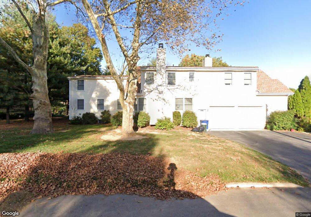
201 Bridgeboro Rd Moorestown, NJ 08057
Estimated Value: $1,151,168 - $1,390,000
4
Beds
4
Baths
4,111
Sq Ft
$300/Sq Ft
Est. Value
About This Home
This home is located at 201 Bridgeboro Rd, Moorestown, NJ 08057 and is currently estimated at $1,235,056, approximately $300 per square foot. 201 Bridgeboro Rd is a home located in Burlington County with nearby schools including George C. Baker Elementary School, Moorestown Upper Elementary School, and William Allen Middle School.
Ownership History
Date
Name
Owned For
Owner Type
Purchase Details
Closed on
Jul 12, 2011
Sold by
Halbe Margaret D
Bought by
Halbe David J
Current Estimated Value
Home Financials for this Owner
Home Financials are based on the most recent Mortgage that was taken out on this home.
Original Mortgage
$100,000
Interest Rate
4.53%
Mortgage Type
Future Advance Clause Open End Mortgage
Purchase Details
Closed on
Jul 30, 1997
Sold by
Stevens Timothy A and Jeffrey Stevens W
Bought by
Halbe David J
Create a Home Valuation Report for This Property
The Home Valuation Report is an in-depth analysis detailing your home's value as well as a comparison with similar homes in the area
Home Values in the Area
Average Home Value in this Area
Purchase History
| Date | Buyer | Sale Price | Title Company |
|---|---|---|---|
| Halbe David J | -- | None Available | |
| Halbe David J | -- | -- |
Source: Public Records
Mortgage History
| Date | Status | Borrower | Loan Amount |
|---|---|---|---|
| Closed | Halbe David J | $100,000 |
Source: Public Records
Tax History Compared to Growth
Tax History
| Year | Tax Paid | Tax Assessment Tax Assessment Total Assessment is a certain percentage of the fair market value that is determined by local assessors to be the total taxable value of land and additions on the property. | Land | Improvement |
|---|---|---|---|---|
| 2025 | $15,516 | $546,900 | $181,800 | $365,100 |
| 2024 | $15,045 | $546,900 | $181,800 | $365,100 |
| 2023 | $15,045 | $546,900 | $181,800 | $365,100 |
| 2022 | $14,892 | $546,900 | $181,800 | $365,100 |
| 2021 | $14,695 | $546,900 | $181,800 | $365,100 |
| 2020 | $14,602 | $546,900 | $181,800 | $365,100 |
| 2019 | $14,345 | $546,900 | $181,800 | $365,100 |
| 2018 | $13,957 | $546,900 | $181,800 | $365,100 |
| 2017 | $14,077 | $546,900 | $181,800 | $365,100 |
| 2016 | $14,028 | $546,900 | $181,800 | $365,100 |
| 2015 | $13,858 | $546,900 | $181,800 | $365,100 |
| 2014 | $13,158 | $546,900 | $181,800 | $365,100 |
Source: Public Records
Map
Nearby Homes
- 863 Golf View Rd
- 744 Signal Light Rd
- 205 E Central Ave
- 343 Tom Brown Rd
- 7 Whitetail Ct
- 347 Tom Brown Rd
- 628 Windsock Way
- 308 Elm St
- 133 Plum St Unit 6
- 80 E 3rd St
- 82 E 3rd St
- 66 E 3rd St
- 50 E 3rd St
- 415 Bridgeboro Rd
- 543 Bethel Ave
- 15 E 2nd St
- 142 Fox Chase Dr
- 493 N Church St
- 2801 Riverton Rd
- 25 Oriole Way
- 205 Bridgeboro Rd
- 207 Bridgeboro Rd
- 5 Rhoads Ave
- 202 Bridgeboro Rd
- 3 Rhoads Ave
- 1 Rhoads Ave
- 7 Broadacres Ct
- 211 Bridgeboro Rd
- 213 Bridgeboro Rd
- 879 Golf View Rd
- 1 Broadacres Ct
- 120 Pheasant Field Ln
- 6 Broadacres Ct
- 116 Pheasant Field Ln
- 877 Golf View Rd
- 875 Golf View Rd
- 112 Pheasant Field Ln
- 880 Golf View Rd
- 170 Bridgeboro Rd
- 124 Pheasant Field Ln