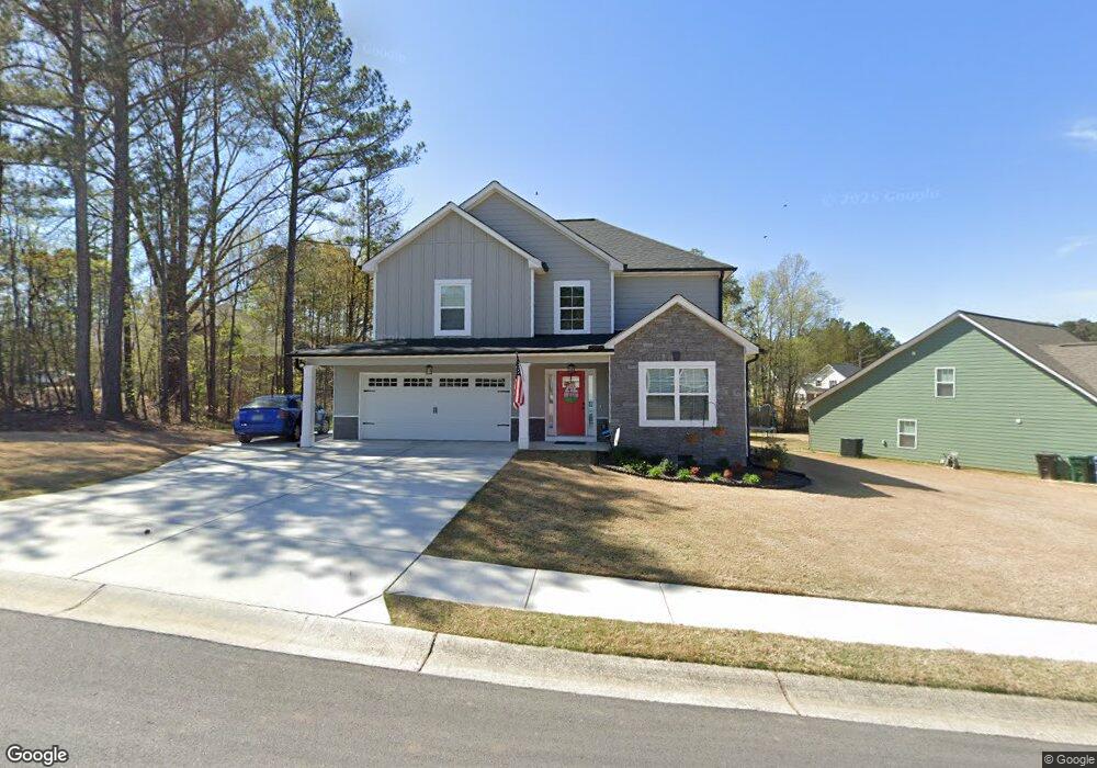
201 Brookstone Dr Unit 88 Carrollton, GA 30116
Estimated Value: $393,187 - $435,000
4
Beds
3
Baths
2,540
Sq Ft
$161/Sq Ft
Est. Value
About This Home
This home is located at 201 Brookstone Dr Unit 88, Carrollton, GA 30116 and is currently estimated at $409,297, approximately $161 per square foot. 201 Brookstone Dr Unit 88 is a home located in Carroll County with nearby schools including Carrollton Elementary School, Carrollton Upper Elementary School, and Carrollton Middle School.
Ownership History
Date
Name
Owned For
Owner Type
Purchase Details
Closed on
Aug 20, 2020
Sold by
Arbor Design Grp Llc
Bought by
Redmond Edward B and Redmond Jennie L
Current Estimated Value
Home Financials for this Owner
Home Financials are based on the most recent Mortgage that was taken out on this home.
Original Mortgage
$230,858
Outstanding Balance
$160,055
Interest Rate
3%
Mortgage Type
New Conventional
Estimated Equity
$249,242
Purchase Details
Closed on
Nov 15, 2019
Sold by
Stonecrest Development Llc
Bought by
Arbor Design Grp Llc
Home Financials for this Owner
Home Financials are based on the most recent Mortgage that was taken out on this home.
Original Mortgage
$215,250
Interest Rate
3.6%
Mortgage Type
Commercial
Create a Home Valuation Report for This Property
The Home Valuation Report is an in-depth analysis detailing your home's value as well as a comparison with similar homes in the area
Home Values in the Area
Average Home Value in this Area
Purchase History
| Date | Buyer | Sale Price | Title Company |
|---|---|---|---|
| Redmond Edward B | $288,572 | -- | |
| Arbor Design Grp Llc | $25,000 | -- |
Source: Public Records
Mortgage History
| Date | Status | Borrower | Loan Amount |
|---|---|---|---|
| Open | Redmond Edward B | $230,858 | |
| Previous Owner | Arbor Design Grp Llc | $215,250 |
Source: Public Records
Tax History Compared to Growth
Tax History
| Year | Tax Paid | Tax Assessment Tax Assessment Total Assessment is a certain percentage of the fair market value that is determined by local assessors to be the total taxable value of land and additions on the property. | Land | Improvement |
|---|---|---|---|---|
| 2024 | $4,109 | $163,470 | $10,000 | $153,470 |
| 2023 | $4,109 | $166,308 | $10,000 | $156,308 |
| 2022 | $3,721 | $135,323 | $10,000 | $125,323 |
| 2021 | $3,253 | $117,226 | $10,000 | $107,226 |
| 2020 | $292 | $10,000 | $10,000 | $0 |
| 2019 | $147 | $5,000 | $5,000 | $0 |
| 2018 | $150 | $5,000 | $5,000 | $0 |
| 2017 | $150 | $5,000 | $5,000 | $0 |
| 2016 | $151 | $5,000 | $5,000 | $0 |
| 2015 | $77 | $2,500 | $2,500 | $0 |
| 2014 | $109 | $3,500 | $3,500 | $0 |
Source: Public Records
Map
Nearby Homes
- 143 Brookstone Dr
- 333 Brookstone Dr
- 141 Mill Pond Crossing
- 217 Summer Chase
- 207 Meadow Lake Dr
- 207 Retreat Way
- 214 Meadow Run
- 301 Retreat Way
- 216 Lane Dr
- 214 Lane Dr
- 212 Lane Dr Unit LOT 60
- 212 Lane Dr
- 210 Lane Dr Unit LOT 61
- 210 Lane Dr
- 202 Laney Dr
- Plan 2121 at Canterbury Villas
- Plan 2307 at Canterbury Villas
- 204 Chaucer Ln
- Plan 1522 at Canterbury Villas
- Plan 1634 at Canterbury Villas
- 205 Brookstone Dr
- 151 Brookstone Dr
- 200 Brookstone Dr
- 202 Brookstone Dr
- 204 Brookstone Dr
- 206 Brookstone Dr
- 334 Stonecrest Dr
- 103 Fieldstone Cir
- 102 Fieldstone Cir
- 208 Brookstone Dr
- 152 Brookstone Dr
- 332 Stonecrest Dr
- 150 Brookstone Dr
- 349 Stonecrest Dr
- 105 Fieldstone Cir
- 335 Stonecrest Dr
- 104 Fieldstone Cir
- 148 Brookstone Dr
- 145 Brookstone Dr
- 333 Stonecrest Dr Unit 125