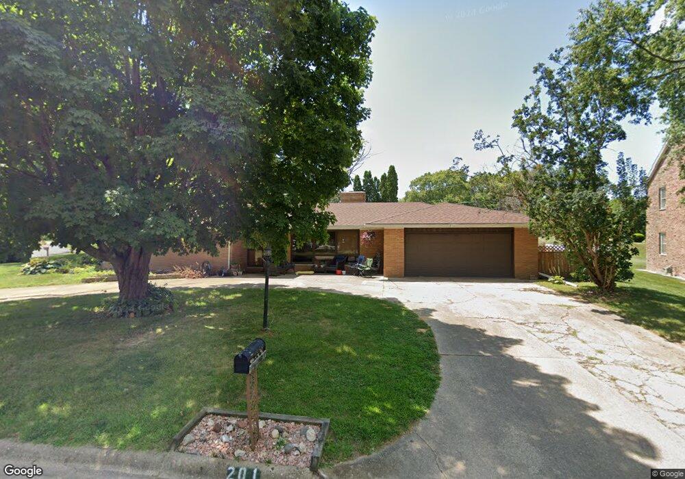
201 Burning Tree Dr Pekin, IL 61554
North of Broadway NeighborhoodEstimated Value: $208,000 - $287,000
3
Beds
3
Baths
2,178
Sq Ft
$115/Sq Ft
Est. Value
About This Home
This home is located at 201 Burning Tree Dr, Pekin, IL 61554 and is currently estimated at $249,823, approximately $114 per square foot. 201 Burning Tree Dr is a home located in Tazewell County with nearby schools including L.E. Starke Elementary School, Washington Intermediate School, and Edison Junior High School.
Ownership History
Date
Name
Owned For
Owner Type
Purchase Details
Closed on
Jan 5, 2011
Sold by
Hardt Dane N and Hardt Barbara M
Bought by
Pollman Jeffery J and Pollman Jennifer N
Current Estimated Value
Home Financials for this Owner
Home Financials are based on the most recent Mortgage that was taken out on this home.
Original Mortgage
$126,704
Outstanding Balance
$84,164
Interest Rate
4.25%
Mortgage Type
FHA
Estimated Equity
$165,659
Create a Home Valuation Report for This Property
The Home Valuation Report is an in-depth analysis detailing your home's value as well as a comparison with similar homes in the area
Home Values in the Area
Average Home Value in this Area
Purchase History
| Date | Buyer | Sale Price | Title Company |
|---|---|---|---|
| Pollman Jeffery J | $130,000 | Chicago Title |
Source: Public Records
Mortgage History
| Date | Status | Borrower | Loan Amount |
|---|---|---|---|
| Open | Pollman Jeffery J | $126,704 |
Source: Public Records
Tax History
| Year | Tax Paid | Tax Assessment Tax Assessment Total Assessment is a certain percentage of the fair market value that is determined by local assessors to be the total taxable value of land and additions on the property. | Land | Improvement |
|---|---|---|---|---|
| 2024 | $5,270 | $73,980 | $12,720 | $61,260 |
| 2023 | $5,270 | $67,920 | $11,680 | $56,240 |
| 2022 | $4,879 | $62,820 | $10,800 | $52,020 |
| 2021 | $4,639 | $60,400 | $10,380 | $50,020 |
| 2020 | $4,555 | $59,670 | $10,890 | $48,780 |
| 2019 | $4,425 | $59,670 | $10,890 | $48,780 |
| 2018 | $4,322 | $59,670 | $10,890 | $48,780 |
| 2017 | $4,843 | $67,630 | $12,920 | $54,710 |
| 2016 | $4,749 | $65,510 | $12,510 | $53,000 |
| 2015 | $4,526 | $0 | $0 | $0 |
| 2013 | $4,440 | $65,510 | $12,510 | $53,000 |
Source: Public Records
Map
Nearby Homes
- 203 Country Club Dr
- 111 Pin Oak Dr
- LOT 90 Aspen Ct
- LOT 92 Aspen Ct
- LOT 95 Aspen Ct
- LOT 73 Aspen Ct
- LOT 86 Aspen Ct
- LOT 74 Aspen Ct
- LOT 96 Aspen Ct
- LOT 91 Aspen Ct
- LOT 71 Dogwood Ln
- LOT 85 Dogwood Ln
- LOT 78 Dogwood Ln
- LOT 77 Dogwood Ln
- LOT 83 Dogwood Ln
- LOT 69 Dogwood Ln
- LOT 97 Dogwood Ln
- LOT 72 Dogwood Ln
- Lot 68 Dogwood Ln
- LOT 70 Dogwood Ln
- 203 Burning Tree Dr
- 107 Country Club Dr
- 200 Burning Tree Dr
- 105 Country Club Dr
- 202 Burning Tree Dr
- 106 Country Club Dr
- 104 Country Club Dr
- 3015 Broadway St
- 203 Country Club Dr Unit 54
- 103 Country Club Dr
- 103 Inverness Dr
- 108 Country Club Dr
- 207 Burning Tree Dr
- 204 Burning Tree Dr
- 100 Inverness Dr
- 205 Country Club Dr
- 101 Country Club Dr
- 105 Inverness Dr
- 209 Burning Tree Dr
- 3013 Broadway St
Your Personal Tour Guide
Ask me questions while you tour the home.