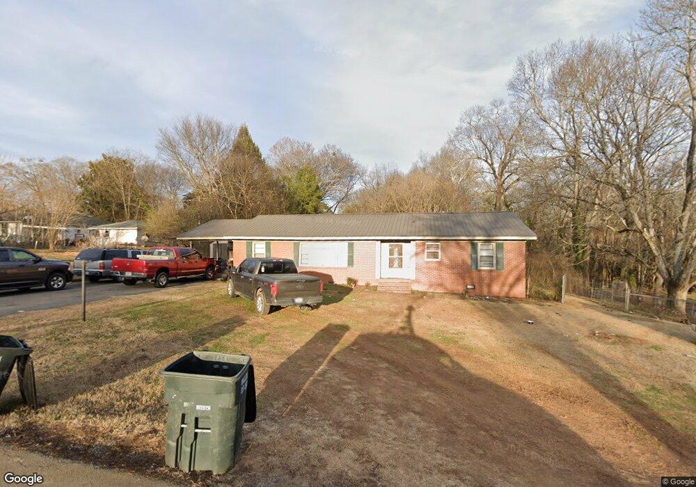
201 Burton Dr Calhoun, GA 30701
Estimated Value: $149,000 - $240,875
3
Beds
1
Bath
1,782
Sq Ft
$114/Sq Ft
Est. Value
About This Home
This home is located at 201 Burton Dr, Calhoun, GA 30701 and is currently estimated at $203,719, approximately $114 per square foot. 201 Burton Dr is a home located in Gordon County with nearby schools including Calhoun Elementary School, Calhoun Middle School, and Calhoun High School.
Ownership History
Date
Name
Owned For
Owner Type
Purchase Details
Closed on
Feb 13, 2024
Sold by
Goss Larry P
Bought by
Kirkland David and Knowles Angel
Current Estimated Value
Home Financials for this Owner
Home Financials are based on the most recent Mortgage that was taken out on this home.
Original Mortgage
$90,000
Outstanding Balance
$85,567
Interest Rate
6.6%
Mortgage Type
New Conventional
Estimated Equity
$118,152
Purchase Details
Closed on
Mar 9, 2020
Sold by
Goss Ronald
Bought by
Goss Larry P
Purchase Details
Closed on
Aug 8, 1968
Bought by
Goss Zane
Create a Home Valuation Report for This Property
The Home Valuation Report is an in-depth analysis detailing your home's value as well as a comparison with similar homes in the area
Purchase History
| Date | Buyer | Sale Price | Title Company |
|---|---|---|---|
| Kirkland David | $90,000 | -- | |
| Goss Larry P | $60,000 | -- | |
| Goss Zane | -- | -- |
Source: Public Records
Mortgage History
| Date | Status | Borrower | Loan Amount |
|---|---|---|---|
| Open | Kirkland David | $90,000 |
Source: Public Records
Tax History
| Year | Tax Paid | Tax Assessment Tax Assessment Total Assessment is a certain percentage of the fair market value that is determined by local assessors to be the total taxable value of land and additions on the property. | Land | Improvement |
|---|---|---|---|---|
| 2025 | $1,321 | $50,280 | $8,800 | $41,480 |
| 2024 | $1,536 | $54,640 | $8,800 | $45,840 |
| 2023 | $1,451 | $51,600 | $8,800 | $42,800 |
| 2022 | $384 | $40,360 | $8,800 | $31,560 |
| 2021 | $943 | $31,680 | $8,000 | $23,680 |
| 2020 | $1,043 | $34,760 | $5,840 | $28,920 |
| 2019 | $387 | $34,760 | $5,840 | $28,920 |
| 2018 | $211 | $25,880 | $4,600 | $21,280 |
| 2017 | $177 | $22,000 | $4,160 | $17,840 |
| 2016 | $177 | $22,000 | $4,160 | $17,840 |
| 2015 | $187 | $22,880 | $4,920 | $17,960 |
| 2014 | $203 | $24,819 | $4,928 | $19,891 |
Source: Public Records
Map
Nearby Homes
- 00 Hwy 53 and Kenmoreland Cir
- 00 Cir
- 111 Lewis Dr SE
- 108 Rips Rd
- 199 Cherry St SE
- 0 W Belmont Dr Unit 10489910
- 1311 Us Highway 41
- 402 Linda Ln
- 0 S Wall St Unit 10665175
- 0 Deer Park Ln Unit 10659841
- 0 Deer Park Ln Unit 7692335
- 123 Deer Park Ln
- 111 Sylvan Dr
- 119 Telfair St
- 1401 U S 41
- 507 Linda Ln
- 511 Circle Dr
- 180 Honeysuckle Dr SE
- 342 Jo Ann Dr SE
- The Kora Plan at Salacoa - Wildflower
- 303 E Belmont Dr
- 305 E Belmont Dr
- 301 E Belmont Dr
- 207 E Belmont Dr
- 604 Peters St
- 300 E Belmont Dr
- 602 Peters St
- 302 E Belmont Dr
- 203 E Belmont Dr
- 306 E Belmont Dr
- 308 E Belmont Dr
- 308 E Belmont Dr
- 600 Peters St
- 309 E Belmont Dr
- 206 E Belmont Dr
- 0 Kenmoreland Dr Unit 8985136
- 0 Kenmoreland Dr Unit 6885322
- 204 E Belmont Dr
- 201 E Belmont Dr
- 618 Peters St
Your Personal Tour Guide
Ask me questions while you tour the home.