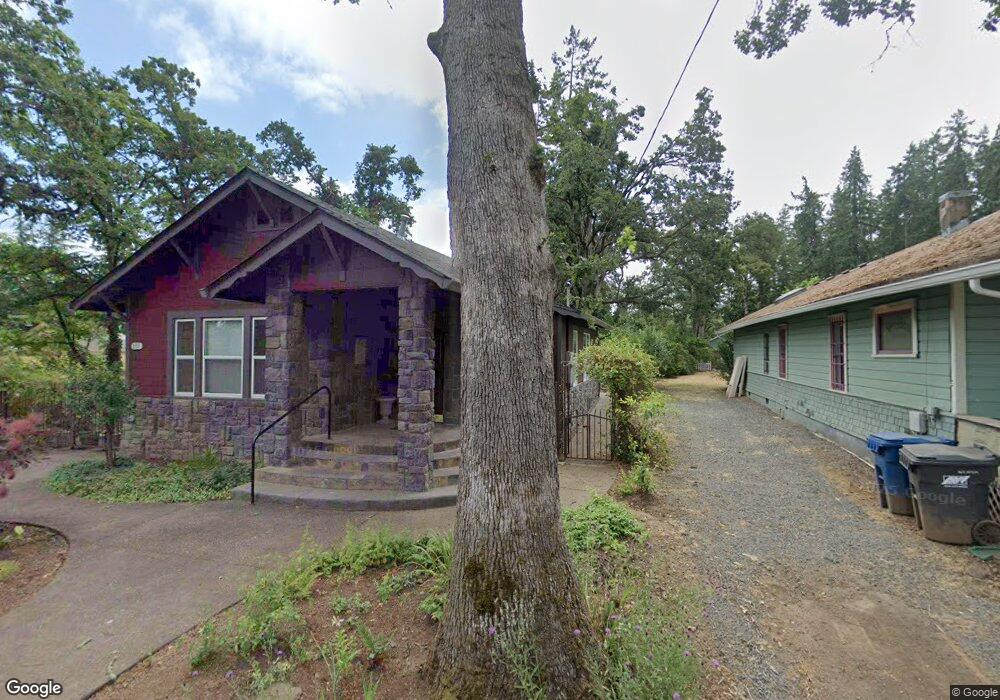
201 Charles Ave Silverton, OR 97381
Estimated Value: $377,000 - $469,000
2
Beds
1
Bath
901
Sq Ft
$464/Sq Ft
Est. Value
About This Home
This home is located at 201 Charles Ave, Silverton, OR 97381 and is currently estimated at $417,898, approximately $463 per square foot. 201 Charles Ave is a home located in Marion County with nearby schools including Robert Frost Elementary School, Silverton Middle School, and Silverton High School.
Ownership History
Date
Name
Owned For
Owner Type
Purchase Details
Closed on
Apr 22, 2014
Sold by
Mbank
Bought by
201 Charles Avenue Llc
Current Estimated Value
Purchase Details
Closed on
Aug 22, 2006
Sold by
Salem Mohsen
Bought by
201 Charles Avenue Llc
Purchase Details
Closed on
Oct 23, 2001
Sold by
Coffelt Marvel Joan
Bought by
Salem Hengameh
Home Financials for this Owner
Home Financials are based on the most recent Mortgage that was taken out on this home.
Original Mortgage
$88,000
Interest Rate
6.87%
Mortgage Type
Purchase Money Mortgage
Create a Home Valuation Report for This Property
The Home Valuation Report is an in-depth analysis detailing your home's value as well as a comparison with similar homes in the area
Home Values in the Area
Average Home Value in this Area
Purchase History
| Date | Buyer | Sale Price | Title Company |
|---|---|---|---|
| 201 Charles Avenue Llc | -- | Fidelity Natl Title Co Of Or | |
| 201 Charles Avenue Llc | -- | None Available | |
| Salem Hengameh | $110,000 | Key Title Company |
Source: Public Records
Mortgage History
| Date | Status | Borrower | Loan Amount |
|---|---|---|---|
| Previous Owner | Salem Hengameh | $88,000 |
Source: Public Records
Tax History Compared to Growth
Tax History
| Year | Tax Paid | Tax Assessment Tax Assessment Total Assessment is a certain percentage of the fair market value that is determined by local assessors to be the total taxable value of land and additions on the property. | Land | Improvement |
|---|---|---|---|---|
| 2024 | $3,000 | $181,030 | -- | -- |
| 2023 | $2,923 | $175,760 | $0 | $0 |
| 2022 | $2,768 | $170,650 | $0 | $0 |
| 2021 | $2,693 | $165,680 | $0 | $0 |
| 2020 | $2,626 | $160,860 | $0 | $0 |
| 2019 | $2,549 | $156,180 | $0 | $0 |
| 2018 | $2,559 | $0 | $0 | $0 |
| 2017 | $2,502 | $0 | $0 | $0 |
| 2016 | $2,456 | $0 | $0 | $0 |
| 2015 | $2,433 | $0 | $0 | $0 |
| 2014 | $2,359 | $0 | $0 | $0 |
Source: Public Records
Map
Nearby Homes