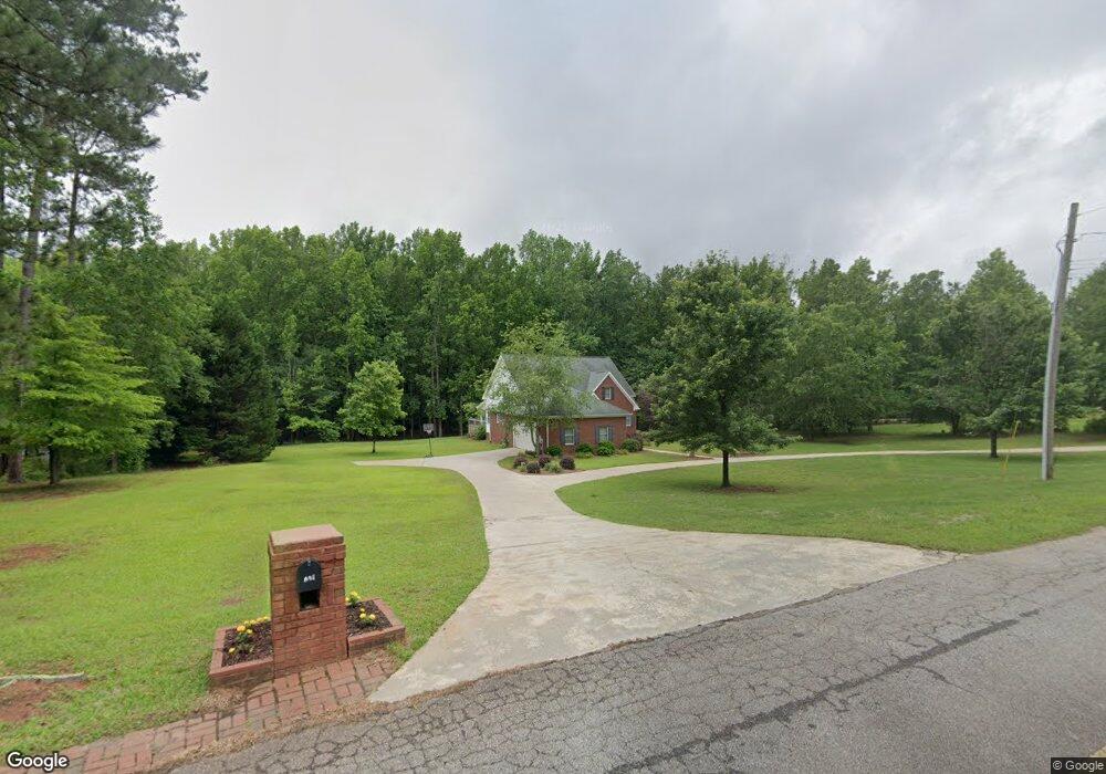
201 Conifer Dr Forsyth, GA 31029
Estimated Value: $395,487 - $595,000
3
Beds
4
Baths
2,672
Sq Ft
$180/Sq Ft
Est. Value
About This Home
This home is located at 201 Conifer Dr, Forsyth, GA 31029 and is currently estimated at $480,829, approximately $179 per square foot. 201 Conifer Dr is a home located in Monroe County with nearby schools including T.G. Scott Elementary School and Mary Persons High School.
Ownership History
Date
Name
Owned For
Owner Type
Purchase Details
Closed on
Aug 17, 2018
Sold by
Walker Bennett R
Bought by
Smith Stephen L and Smith Margie M
Current Estimated Value
Purchase Details
Closed on
May 30, 2008
Sold by
Cowart Scott K
Bought by
Walker Bennett R and Walker Linda M
Home Financials for this Owner
Home Financials are based on the most recent Mortgage that was taken out on this home.
Original Mortgage
$275,000
Interest Rate
6.02%
Mortgage Type
New Conventional
Purchase Details
Closed on
Apr 27, 2000
Bought by
Cowart Scott K and Cowart Cindy L
Create a Home Valuation Report for This Property
The Home Valuation Report is an in-depth analysis detailing your home's value as well as a comparison with similar homes in the area
Home Values in the Area
Average Home Value in this Area
Purchase History
| Date | Buyer | Sale Price | Title Company |
|---|---|---|---|
| Smith Stephen L | $274,000 | -- | |
| Walker Bennett R | $275,000 | -- | |
| Cowart Scott K | $33,200 | -- |
Source: Public Records
Mortgage History
| Date | Status | Borrower | Loan Amount |
|---|---|---|---|
| Previous Owner | Walker Bennett R | $275,000 |
Source: Public Records
Tax History
| Year | Tax Paid | Tax Assessment Tax Assessment Total Assessment is a certain percentage of the fair market value that is determined by local assessors to be the total taxable value of land and additions on the property. | Land | Improvement |
|---|---|---|---|---|
| 2025 | $3,603 | $130,840 | $16,000 | $114,840 |
| 2024 | $3,603 | $130,840 | $16,000 | $114,840 |
| 2023 | $2,512 | $111,720 | $16,000 | $95,720 |
| 2022 | $2,974 | $111,720 | $16,000 | $95,720 |
| 2021 | $3,069 | $111,720 | $16,000 | $95,720 |
| 2020 | $2,716 | $96,640 | $16,000 | $80,640 |
| 2019 | $2,735 | $96,640 | $16,000 | $80,640 |
| 2018 | $2,640 | $93,440 | $16,000 | $77,440 |
| 2017 | $2,996 | $93,440 | $16,000 | $77,440 |
| 2016 | $2,525 | $93,440 | $16,000 | $77,440 |
| 2015 | $2,408 | $93,440 | $16,000 | $77,440 |
| 2014 | $2,379 | $93,440 | $16,000 | $77,440 |
Source: Public Records
Map
Nearby Homes
- 436 Magnolia Ct
- 0 Benson Ham Rd Unit OUTPARCEL 1 10551782
- 0 Benson Ham Rd Unit OUTPARCEL 2 10558340
- 4580 Capulet Ct
- 0 Patrol Rd Unit 10711373
- 1251 Forsyth Landing Dr
- 4355 Cornwall Dr
- 0 Loraine Forest Courts Unit 10706300
- 5387 Felles Way
- 5387 Felles Way Unit 360
- 5393 Felles Way Unit 359
- 4616 Capulet Ct
- 5399 Felles Way Unit 358
- 5399 Felles Way
- 5407 Felles Way Unit 356
- 285 E Main St
- 100 Gardens
- 0 Boxankle Unit 10706468
- 104 Gardens
- 4604 Capulet Ct
Your Personal Tour Guide
Ask me questions while you tour the home.