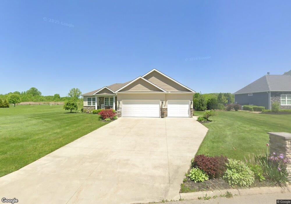
201 Dornoch St Cortland, OH 44410
Estimated Value: $328,000 - $420,000
3
Beds
2
Baths
1,624
Sq Ft
$222/Sq Ft
Est. Value
About This Home
This home is located at 201 Dornoch St, Cortland, OH 44410 and is currently estimated at $360,005, approximately $221 per square foot. 201 Dornoch St is a home with nearby schools including Currie Elementary School, Baker Elementary School, and Mathews High School.
Ownership History
Date
Name
Owned For
Owner Type
Purchase Details
Closed on
Jan 9, 2018
Sold by
Trumbull County Land Reutilization Corpo
Bought by
Thoma Robert F and Thoma Lana J
Current Estimated Value
Purchase Details
Closed on
May 9, 2017
Sold by
Pmd Builder
Bought by
Trumbull County Cach
Purchase Details
Closed on
Dec 30, 2004
Sold by
Walnut Run Land Co
Bought by
Pmd Builders Ltd
Create a Home Valuation Report for This Property
The Home Valuation Report is an in-depth analysis detailing your home's value as well as a comparison with similar homes in the area
Home Values in the Area
Average Home Value in this Area
Purchase History
| Date | Buyer | Sale Price | Title Company |
|---|---|---|---|
| Thoma Robert F | -- | None Available | |
| Trumbull County Cach | -- | None Available | |
| Pmd Builders Ltd | $908,800 | The Title Co Of Warren | |
| Pmd Builders Ltd | $908,800 | The Title Co Of Warren |
Source: Public Records
Tax History Compared to Growth
Tax History
| Year | Tax Paid | Tax Assessment Tax Assessment Total Assessment is a certain percentage of the fair market value that is determined by local assessors to be the total taxable value of land and additions on the property. | Land | Improvement |
|---|---|---|---|---|
| 2024 | $4,462 | $92,860 | $9,800 | $83,060 |
| 2023 | $4,462 | $92,860 | $9,800 | $83,060 |
| 2022 | $4,503 | $74,100 | $9,800 | $64,300 |
| 2021 | $4,514 | $74,100 | $9,800 | $64,300 |
| 2020 | $4,527 | $74,100 | $9,800 | $64,300 |
| 2019 | $4,190 | $65,700 | $9,800 | $55,900 |
| 2018 | $637 | $9,800 | $9,800 | $0 |
| 2017 | $635 | $9,800 | $9,800 | $0 |
| 2016 | $932 | $13,970 | $13,970 | $0 |
| 2015 | $925 | $13,970 | $13,970 | $0 |
| 2014 | $883 | $13,970 | $13,970 | $0 |
| 2013 | $886 | $13,970 | $13,970 | $0 |
Source: Public Records
Map
Nearby Homes
- 0 St Andrews Unit 5113795
- 121 Fairway Dr
- 428 Cherry Hill Ln
- 404 Cherry Hill Ln
- 160 Saint Andrews
- 525 Sycamore Trail
- 507 Tournament Trail
- 400 Tournament Trail Unit 400
- 124 Saint Andrews
- 4400 Ridge Rd
- 155 Heritage Ln
- 4869 Phillips Rice Rd
- 101 Elizabeth Ct
- 0 N High St
- 278 Rosewae Ave
- 20 Harneds Landing Unit 20
- 408 S Colonial Dr
- 151 Cedar Cir
- 163 N Mecca St Unit 167
- 105 Diamond Way Unit 105