Estimated Value: $87,000 - $136,000
Studio
1
Bath
1,277
Sq Ft
$81/Sq Ft
Est. Value
About This Home
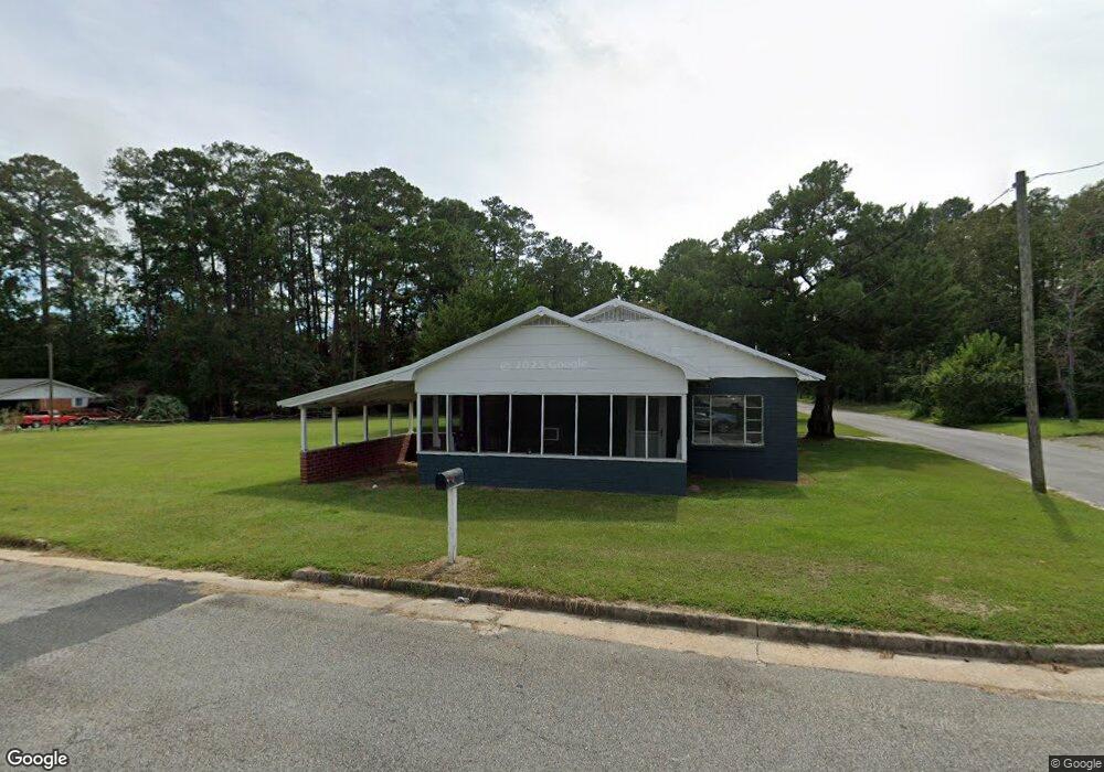
This home is located at 201 E 20th St, Alma, GA 31510 and is currently estimated at $103,043, approximately $80 per square foot. 201 E 20th St is a home located in Bacon County with nearby schools including Bacon County Primary School, Bacon County Elementary School, and Bacon County Middle School.
Ownership History
Date
Name
Owned For
Owner Type
Purchase Details
Closed on
Dec 18, 2013
Sold by
Mcquaig Vickie Dale
Bought by
Arrington Gail Marie
Current Estimated Value
Purchase Details
Closed on
Jun 3, 2011
Sold by
Godwin Amy M
Bought by
Arrington Gail Godwin
Purchase Details
Closed on
Jul 24, 2006
Sold by
Godwin Cecil B
Bought by
Mcquaig Vickie Dale and Godwin Amy M
Purchase Details
Closed on
Jul 15, 2004
Sold by
King Denmark Mr and King Mrs
Bought by
Godwin Cecil B
Purchase Details
Closed on
Sep 28, 2000
Sold by
Godwin Cecil
Bought by
Godwin Cecil
Purchase Details
Closed on
Jun 2, 1995
Bought by
Godwin Cecil
Create a Home Valuation Report for This Property
The Home Valuation Report is an in-depth analysis detailing your home's value as well as a comparison with similar homes in the area
Home Values in the Area
Average Home Value in this Area
Purchase History
| Date | Buyer | Sale Price | Title Company |
|---|---|---|---|
| Arrington Gail Marie | -- | -- | |
| Arrington Gail Godwin | -- | -- | |
| Mcquaig Vickie Dale | -- | -- | |
| Godwin Cecil B | -- | -- | |
| Godwin Cecil | -- | -- | |
| Godwin Cecil | $1,000 | -- |
Source: Public Records
Tax History
| Year | Tax Paid | Tax Assessment Tax Assessment Total Assessment is a certain percentage of the fair market value that is determined by local assessors to be the total taxable value of land and additions on the property. | Land | Improvement |
|---|---|---|---|---|
| 2025 | $794 | $23,664 | $7,160 | $16,504 |
| 2024 | $816 | $22,464 | $7,160 | $15,304 |
| 2023 | $744 | $19,304 | $5,240 | $14,064 |
| 2022 | $601 | $15,584 | $5,240 | $10,344 |
| 2021 | $602 | $15,624 | $5,240 | $10,384 |
| 2020 | $631 | $15,657 | $4,780 | $10,877 |
| 2019 | $631 | $15,657 | $4,780 | $10,877 |
| 2018 | $631 | $15,688 | $4,780 | $10,908 |
| 2017 | $632 | $15,688 | $4,780 | $10,908 |
| 2016 | $632 | $15,688 | $4,780 | $10,908 |
| 2015 | $652 | $16,165 | $5,165 | $11,000 |
| 2014 | $659 | $16,165 | $5,165 | $11,000 |
| 2013 | $659 | $21,214 | $5,165 | $16,048 |
Source: Public Records
Map
Nearby Homes
- 403 S Ware St
- 117 Grace Loop Unit 1
- 122 Grace Loop Unit 1
- 108 Daughtry Rd
- 611 S Bead St
- 9TH E 417
- 907 N Pierce St
- 701 Smallee St
- 113 Brite Blue Dr
- 166 Grace Loop Unit 1
- 198 Meadow Rd
- 1109 W 4th Street Extension
- 0 W 4th Street Extension Unit 10650393
- 0 Lake Lure Dr
- 220 Lake Shore Dr
- 220 Lakeshore Dr
- 1348 U S 1
- 1608 W 4th St
- 1813 W 12th St
- 600 Teakwood Rd
Your Personal Tour Guide
Ask me questions while you tour the home.