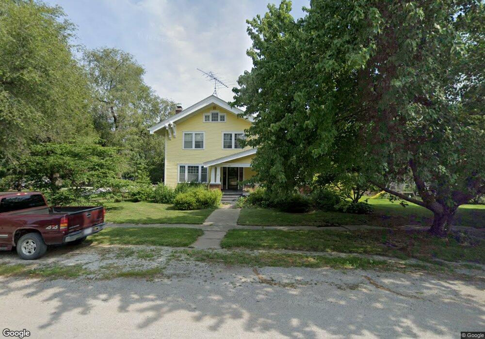
201 E Samuel St Hamilton, MO 64644
Estimated Value: $209,298 - $320,000
Studio
1
Bath
2,666
Sq Ft
$109/Sq Ft
Est. Value
About This Home
This home is located at 201 E Samuel St, Hamilton, MO 64644 and is currently estimated at $291,325, approximately $109 per square foot. 201 E Samuel St is a home with nearby schools including Hamilton Elementary School, Hamilton Middle School, and Penney High School.
Ownership History
Date
Name
Owned For
Owner Type
Purchase Details
Closed on
Jun 26, 2023
Sold by
Evans William A
Bought by
Campbell Ronald and Campbell Penny
Current Estimated Value
Home Financials for this Owner
Home Financials are based on the most recent Mortgage that was taken out on this home.
Original Mortgage
$14,500
Outstanding Balance
$14,089
Interest Rate
6.69%
Mortgage Type
New Conventional
Estimated Equity
$277,236
Create a Home Valuation Report for This Property
The Home Valuation Report is an in-depth analysis detailing your home's value as well as a comparison with similar homes in the area
Purchase History
| Date | Buyer | Sale Price | Title Company |
|---|---|---|---|
| Campbell Ronald | -- | None Listed On Document |
Source: Public Records
Mortgage History
| Date | Status | Borrower | Loan Amount |
|---|---|---|---|
| Open | Campbell Ronald | $14,500 |
Source: Public Records
Tax History
| Year | Tax Paid | Tax Assessment Tax Assessment Total Assessment is a certain percentage of the fair market value that is determined by local assessors to be the total taxable value of land and additions on the property. | Land | Improvement |
|---|---|---|---|---|
| 2025 | $1,877 | $27,610 | $2,550 | $25,060 |
| 2024 | $1,877 | $24,640 | $2,550 | $22,090 |
| 2023 | $2,117 | $24,640 | $2,550 | $22,090 |
| 2022 | $1,794 | $23,700 | $2,550 | $21,150 |
| 2021 | $2,069 | $23,700 | $2,550 | $21,150 |
| 2020 | $1,859 | $21,850 | $2,550 | $19,300 |
| 2019 | $1,877 | $21,850 | $2,550 | $19,300 |
| 2018 | $1,570 | $19,580 | $1,910 | $17,670 |
| 2017 | $1,570 | $19,580 | $1,910 | $17,670 |
| 2016 | -- | $19,370 | $1,700 | $17,670 |
| 2015 | -- | $19,370 | $1,700 | $17,670 |
| 2013 | -- | $19,050 | $1,270 | $17,780 |
| 2011 | -- | $19,050 | $0 | $0 |
Source: Public Records
Map
Nearby Homes
- 705 N Ritchie St
- 305 N Prairie St
- 303 N Prairie St
- 408 W 6th St
- 202 E Mcgaughy St
- 309 W Samuel St
- 203 W 8th St
- 201 E School St
- 203 S Hughes St
- 108 Rich Hill St
- 510 W Samuel St
- 511 W Mcgaughy St
- W 1/2 Lot 1 Railroad Addition St
- 0 S Colby St
- 800 W Railroad St
- 8806 NW State Route Cc N A
- 8806 NW State Route Cc
- 0 State Route Cc Hwy Unit HMS2565638
- Hwy Cc Unit Lot WP001
- 0 NE State Highway B
- 508 N Burruss St
- 410 N Burruss St
- 507 N Burruss St
- 000 SE Corner of N Burruss & E 6th St
- 501 N Burruss St
- 211 E Samuel St
- 503 N Ewing St
- 511 N Burruss St
- 409 N Burruss St
- 204 E 6th St
- 409 N Ewing St
- 600 N Burruss St
- 407 N Ewing St
- 101 E Samuel St
- 405 N Burruss St
- 103 E 6th St
- 403 N Ewing St
- 502 N Davis St
- 504 N Ewing St
- 203 E Arthur St
Your Personal Tour Guide
Ask me questions while you tour the home.