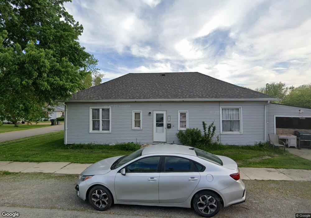
201 E Union St Spencerville, OH 45887
Estimated Value: $76,000 - $102,000
2
Beds
1
Bath
1,232
Sq Ft
$77/Sq Ft
Est. Value
About This Home
This home is located at 201 E Union St, Spencerville, OH 45887 and is currently estimated at $94,736, approximately $76 per square foot. 201 E Union St is a home located in Allen County with nearby schools including Spencerville Elementary School, Spencerville Middle School, and Spencerville High School.
Ownership History
Date
Name
Owned For
Owner Type
Purchase Details
Closed on
Nov 28, 1994
Sold by
Est Freda M Sheets
Bought by
Mccune Robert L and Mccune Cheryl L
Current Estimated Value
Home Financials for this Owner
Home Financials are based on the most recent Mortgage that was taken out on this home.
Original Mortgage
$23,750
Interest Rate
9%
Mortgage Type
New Conventional
Purchase Details
Closed on
Jan 1, 1990
Bought by
Sheets Freda M
Create a Home Valuation Report for This Property
The Home Valuation Report is an in-depth analysis detailing your home's value as well as a comparison with similar homes in the area
Purchase History
| Date | Buyer | Sale Price | Title Company |
|---|---|---|---|
| Mccune Robert L | $25,000 | -- | |
| Sheets Freda M | -- | -- |
Source: Public Records
Mortgage History
| Date | Status | Borrower | Loan Amount |
|---|---|---|---|
| Closed | Mccune Robert L | $23,750 |
Source: Public Records
Tax History
| Year | Tax Paid | Tax Assessment Tax Assessment Total Assessment is a certain percentage of the fair market value that is determined by local assessors to be the total taxable value of land and additions on the property. | Land | Improvement |
|---|---|---|---|---|
| 2024 | $785 | $23,000 | $5,950 | $17,050 |
| 2023 | $689 | $18,840 | $4,870 | $13,970 |
| 2022 | $661 | $17,720 | $4,870 | $12,850 |
| 2021 | $642 | $17,720 | $4,870 | $12,850 |
| 2020 | $1,142 | $15,440 | $4,590 | $10,850 |
| 2019 | $1,142 | $15,440 | $4,590 | $10,850 |
| 2018 | $588 | $15,440 | $4,590 | $10,850 |
| 2017 | $500 | $13,310 | $4,590 | $8,720 |
| 2016 | $491 | $13,310 | $4,590 | $8,720 |
| 2015 | $515 | $13,310 | $4,590 | $8,720 |
| 2014 | $515 | $13,970 | $4,800 | $9,170 |
| 2013 | $524 | $13,970 | $4,800 | $9,170 |
Source: Public Records
Map
Nearby Homes
- 714 Briggs Ave Unit 1
- 408 N Mulberry St
- 313 S Broadway St
- 305 N Broadway St
- 417 W 4th St
- 421 W 4th St
- 433 W 4th St
- 510 S Broadway St
- 522 S Broadway St
- 00 Kleinoeder Rd
- 14101 Allentown Rd
- 594 N Conant Rd
- 21302 Masters Rd
- 21183 Ohio 116
- 3000 S Sunderland Rd
- 3000 Sunderland Rd
- 22284 Ohio 198
- 17683 Ohio 117
- 0 Agerter Rd
- 7570 Fort Amanda Rd
- 706 Briggs Ave
- 202 E Union St
- 710 Briggs Ave
- 125 E Union St
- 707 Briggs Ave
- 711 Briggs Ave
- 207 E Union St
- 124 E Union St
- 715 Briggs Ave
- 600 Briggs Ave
- 704 N Broadway St
- 628 N Broadway St
- 710 N Broadway St
- 714 Briggs Ave
- 714 N Broadway St
- 616 N Broadway St
- 808 N Broadway St
- 631 N Broadway St
- 703 N Broadway St
- 707 N Broadway St
Your Personal Tour Guide
Ask me questions while you tour the home.