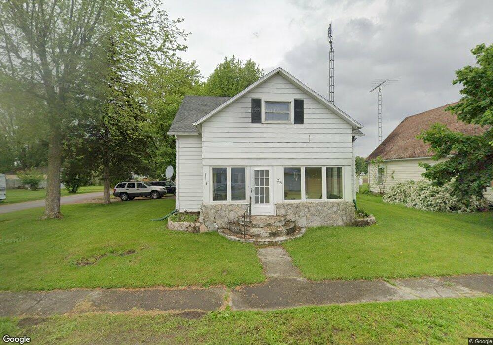
201 E Wood St Middle Point, OH 45863
Estimated Value: $105,462 - $186,000
3
Beds
2
Baths
2,080
Sq Ft
$65/Sq Ft
Est. Value
About This Home
This home is located at 201 E Wood St, Middle Point, OH 45863 and is currently estimated at $135,866, approximately $65 per square foot. 201 E Wood St is a home with nearby schools including Lincolnview Elementary School and Lincolnview Junior/Senior High School.
Ownership History
Date
Name
Owned For
Owner Type
Purchase Details
Closed on
Apr 6, 2007
Sold by
Wells Fargo Bank Na
Bought by
Romes Gerald A and Romes Lori L
Current Estimated Value
Home Financials for this Owner
Home Financials are based on the most recent Mortgage that was taken out on this home.
Original Mortgage
$40,000
Outstanding Balance
$23,524
Interest Rate
6.2%
Mortgage Type
New Conventional
Estimated Equity
$112,342
Purchase Details
Closed on
Jan 8, 2001
Bought by
Option One Woodbridge Lo
Create a Home Valuation Report for This Property
The Home Valuation Report is an in-depth analysis detailing your home's value as well as a comparison with similar homes in the area
Purchase History
| Date | Buyer | Sale Price | Title Company |
|---|---|---|---|
| Romes Gerald A | $40,000 | None Available | |
| Option One Woodbridge Lo | $26,000 | -- | |
| Option One Woodbridge Lo | $26,000 | -- |
Source: Public Records
Mortgage History
| Date | Status | Borrower | Loan Amount |
|---|---|---|---|
| Open | Romes Gerald A | $40,000 |
Source: Public Records
Tax History
| Year | Tax Paid | Tax Assessment Tax Assessment Total Assessment is a certain percentage of the fair market value that is determined by local assessors to be the total taxable value of land and additions on the property. | Land | Improvement |
|---|---|---|---|---|
| 2024 | $985 | $28,940 | $1,410 | $27,530 |
| 2023 | $977 | $28,940 | $1,410 | $27,530 |
| 2022 | $907 | $19,690 | $1,300 | $18,390 |
| 2021 | $912 | $19,690 | $1,300 | $18,390 |
| 2020 | $910 | $19,690 | $1,300 | $18,390 |
| 2019 | $737 | $16,760 | $1,300 | $15,460 |
| 2018 | $714 | $16,760 | $1,300 | $15,460 |
| 2017 | $711 | $16,760 | $1,300 | $15,460 |
| 2016 | $584 | $16,010 | $1,300 | $14,710 |
| 2015 | $575 | $16,010 | $1,300 | $14,710 |
| 2014 | $596 | $16,010 | $1,300 | $14,710 |
| 2013 | $702 | $16,010 | $1,300 | $14,710 |
Source: Public Records
Map
Nearby Homes
- 112 W Railroad St
- 523 E Jackson St
- TBD Dog Creek Rd
- 19195 State Rd
- 19357 Church Rd
- 14998 Middle Point Rd
- 18906 Bebb St
- 10429 Ohio 66
- 15044 Main St
- 19059 Wittington St
- 537 / 539 Toomey
- 709 W 4th St
- 708 W 1st St
- 409 N Bredeick St
- 420 S Cass St
- 21092 St Rt 224
- 629 N Main St
- 702 N Main St
- 424 S Canal St
- 221 S Main St
Your Personal Tour Guide
Ask me questions while you tour the home.