Estimated Value: $212,000 - $260,052
5
Beds
2
Baths
1,912
Sq Ft
$123/Sq Ft
Est. Value
About This Home
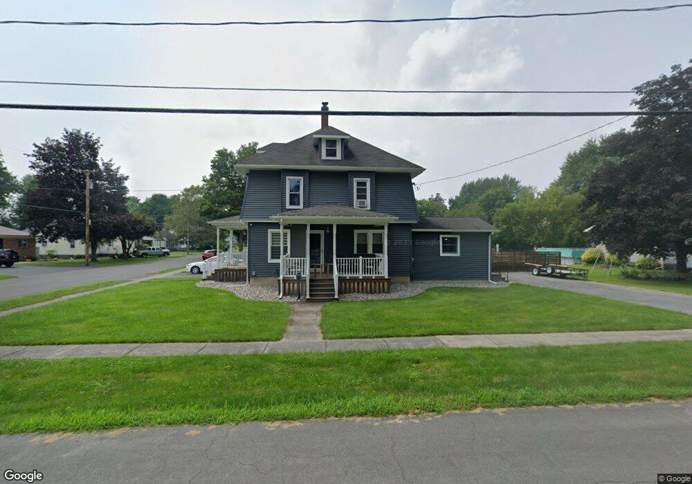
This home is located at 201 Elm St, Minoa, NY 13116 and is currently estimated at $235,013, approximately $122 per square foot. 201 Elm St is a home located in Onondaga County with nearby schools including Minoa Elementary School, Pine Grove Middle School, and East Syracuse Minoa Central High School.
Ownership History
Date
Name
Owned For
Owner Type
Purchase Details
Closed on
Sep 13, 2019
Sold by
Cornish Estelle F
Bought by
Laurin Christopher and Laurin Estelle F
Current Estimated Value
Home Financials for this Owner
Home Financials are based on the most recent Mortgage that was taken out on this home.
Original Mortgage
$35,600
Outstanding Balance
$31,183
Interest Rate
3.6%
Mortgage Type
New Conventional
Estimated Equity
$203,830
Purchase Details
Closed on
Jul 11, 2014
Sold by
Mohorter Brandon
Bought by
Cornish Estelle
Home Financials for this Owner
Home Financials are based on the most recent Mortgage that was taken out on this home.
Original Mortgage
$121,361
Interest Rate
3.75%
Mortgage Type
FHA
Purchase Details
Closed on
Dec 1, 2006
Sold by
Oot Kristen
Bought by
Mohorter Brandon
Create a Home Valuation Report for This Property
The Home Valuation Report is an in-depth analysis detailing your home's value as well as a comparison with similar homes in the area
Home Values in the Area
Average Home Value in this Area
Purchase History
| Date | Buyer | Sale Price | Title Company |
|---|---|---|---|
| Laurin Christopher | -- | -- | |
| Laurin Christopher | -- | -- | |
| Cornish Estelle | $123,600 | Vaughn D. Lang | |
| Mohorter Brandon | $92,900 | -- | |
| Oot Kristen | -- | -- |
Source: Public Records
Mortgage History
| Date | Status | Borrower | Loan Amount |
|---|---|---|---|
| Open | Laurin Christopher | $35,600 | |
| Previous Owner | Cornish Estelle | $121,361 |
Source: Public Records
Tax History Compared to Growth
Tax History
| Year | Tax Paid | Tax Assessment Tax Assessment Total Assessment is a certain percentage of the fair market value that is determined by local assessors to be the total taxable value of land and additions on the property. | Land | Improvement |
|---|---|---|---|---|
| 2024 | $6,623 | $177,700 | $40,500 | $137,200 |
| 2023 | $6,178 | $158,100 | $36,000 | $122,100 |
| 2022 | $5,437 | $138,300 | $31,600 | $106,700 |
| 2021 | $5,313 | $124,600 | $30,400 | $94,200 |
| 2020 | $4,517 | $124,600 | $26,400 | $98,200 |
| 2019 | $982 | $118,000 | $25,000 | $93,000 |
| 2018 | $4,075 | $110,300 | $25,000 | $85,300 |
| 2017 | $950 | $110,300 | $25,000 | $85,300 |
| 2016 | $3,850 | $106,100 | $25,000 | $81,100 |
| 2015 | -- | $106,100 | $25,000 | $81,100 |
| 2014 | -- | $101,000 | $25,000 | $76,000 |
Source: Public Records
Map
Nearby Homes
- 309 N Main St
- 129 S Central Ave
- 13 (Lot 155) Clairborn Ct
- 216 Fay Ln
- 132 Osborne St
- 210 Ruth St
- 117 Colchester Rd
- 402 Ferndale Ln
- 93 Ripplebrook Ln
- 419 Fay Ln
- 103 Lake Forest Dr
- 105 Lake Forest Dr
- 89 Windebank Ln
- 101 Whiskwood Ln
- 203 Windebank Ln
- 11 (Lot 155) Clairborn Ct
- 157 Clairborn Ct
- 211 Windebank Ln
- 12 Clairborn (Lot 162) Ct
- 0000 Richmond Rd E