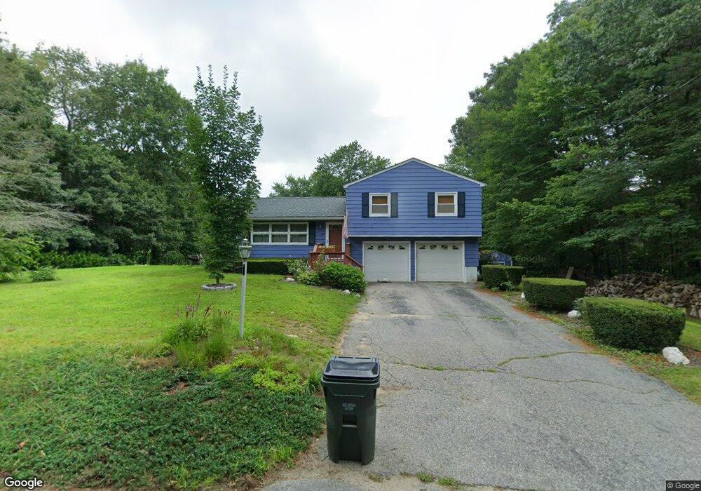
201 Emerson Rd Harrisville, RI 02830
Pascoag-Harrisville NeighborhoodEstimated Value: $413,000 - $437,163
3
Beds
2
Baths
1,606
Sq Ft
$264/Sq Ft
Est. Value
About This Home
This home is located at 201 Emerson Rd, Harrisville, RI 02830 and is currently estimated at $423,291, approximately $263 per square foot. 201 Emerson Rd is a home located in Providence County with nearby schools including Austin T. Levy School, Burrillville Middle School, and Burrillville High School.
Ownership History
Date
Name
Owned For
Owner Type
Purchase Details
Closed on
Nov 16, 2006
Sold by
Davis Robert D and Davis Susan E
Bought by
Dextcr Samuel B and Perkins Cynthia J
Current Estimated Value
Home Financials for this Owner
Home Financials are based on the most recent Mortgage that was taken out on this home.
Original Mortgage
$200,000
Interest Rate
6.33%
Mortgage Type
Purchase Money Mortgage
Purchase Details
Closed on
May 26, 1999
Sold by
Hallworth Scott T and Hallworth Lisa M
Bought by
Davis Robert D and Davis Sean E
Purchase Details
Closed on
Jul 16, 1992
Sold by
Boucher Roger H
Bought by
Hallworth Scott T
Create a Home Valuation Report for This Property
The Home Valuation Report is an in-depth analysis detailing your home's value as well as a comparison with similar homes in the area
Home Values in the Area
Average Home Value in this Area
Purchase History
| Date | Buyer | Sale Price | Title Company |
|---|---|---|---|
| Dextcr Samuel B | $250,000 | -- | |
| Davis Robert D | $137,000 | -- | |
| Hallworth Scott T | $121,500 | -- |
Source: Public Records
Mortgage History
| Date | Status | Borrower | Loan Amount |
|---|---|---|---|
| Open | Hallworth Scott T | $196,350 | |
| Closed | Hallworth Scott T | $200,000 | |
| Closed | Hallworth Scott T | $37,500 |
Source: Public Records
Tax History Compared to Growth
Tax History
| Year | Tax Paid | Tax Assessment Tax Assessment Total Assessment is a certain percentage of the fair market value that is determined by local assessors to be the total taxable value of land and additions on the property. | Land | Improvement |
|---|---|---|---|---|
| 2025 | $4,623 | $388,500 | $107,400 | $281,100 |
| 2024 | $4,185 | $279,400 | $85,900 | $193,500 |
| 2023 | $4,021 | $279,400 | $85,900 | $193,500 |
| 2022 | $3,886 | $279,400 | $85,900 | $193,500 |
| 2021 | $3,576 | $217,800 | $68,800 | $149,000 |
| 2020 | $3,487 | $217,800 | $68,800 | $149,000 |
| 2019 | $3,485 | $217,800 | $68,800 | $149,000 |
| 2018 | $3,209 | $176,300 | $54,600 | $121,700 |
| 2017 | $3,096 | $176,300 | $54,600 | $121,700 |
| 2016 | $3,066 | $176,300 | $54,600 | $121,700 |
| 2015 | $2,747 | $145,500 | $54,600 | $90,900 |
| 2014 | $2,747 | $145,500 | $54,600 | $90,900 |
Source: Public Records
Map
Nearby Homes
- 22 Sanwood Dr
- 130 Hill Rd
- 38 Chapel St
- 361 Chapel St
- 101 Graniteville Rd
- 71 Centennial St
- 48 Shea Ln
- 74 Grove St
- 265 Sayles Ave Unit 1
- 448 Chapel St
- 464 Chapel St
- 161 Sayles Ave
- 0 Mowry St
- 393 Church St
- 248-252 Church St
- 248 Church St
- 156 Broad St
- 0 Griffin St Unit 1387114
- 75 Marion Ave
- 11 Central St