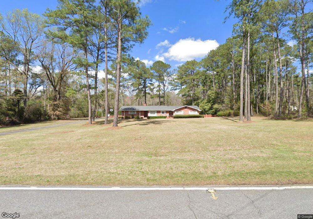
201 Frank Cook Rd Cochran, GA 31014
Estimated Value: $187,000 - $196,000
3
Beds
2
Baths
1,633
Sq Ft
$116/Sq Ft
Est. Value
About This Home
This home is located at 201 Frank Cook Rd, Cochran, GA 31014 and is currently estimated at $190,151, approximately $116 per square foot. 201 Frank Cook Rd is a home located in Bleckley County with nearby schools including Bleckley County Primary School, Bleckley County Elementary School, and Bleckley Middle School.
Ownership History
Date
Name
Owned For
Owner Type
Purchase Details
Closed on
Feb 3, 2021
Sold by
Butts Bernease M
Bought by
Butts Properties Llc
Current Estimated Value
Purchase Details
Closed on
Nov 14, 2011
Sold by
Nesmith A Newell
Bought by
Butts Bernease M
Purchase Details
Closed on
Sep 29, 2002
Sold by
Butts Henry W
Bought by
Butts Bernease M
Purchase Details
Closed on
Oct 29, 1965
Bought by
Butts Henry W
Create a Home Valuation Report for This Property
The Home Valuation Report is an in-depth analysis detailing your home's value as well as a comparison with similar homes in the area
Home Values in the Area
Average Home Value in this Area
Purchase History
| Date | Buyer | Sale Price | Title Company |
|---|---|---|---|
| Butts Properties Llc | -- | -- | |
| Butts Bernease M | $6,500 | -- | |
| Butts Bernease M | -- | -- | |
| Butts Henry W | -- | -- |
Source: Public Records
Tax History Compared to Growth
Tax History
| Year | Tax Paid | Tax Assessment Tax Assessment Total Assessment is a certain percentage of the fair market value that is determined by local assessors to be the total taxable value of land and additions on the property. | Land | Improvement |
|---|---|---|---|---|
| 2024 | $1,940 | $72,520 | $4,640 | $67,880 |
| 2023 | $1,940 | $72,520 | $4,640 | $67,880 |
| 2022 | $1,771 | $65,080 | $4,640 | $60,440 |
| 2021 | $1,494 | $51,320 | $4,640 | $46,680 |
| 2020 | $1,436 | $51,320 | $4,640 | $46,680 |
| 2019 | $1,196 | $42,986 | $7,044 | $35,942 |
| 2018 | $1,264 | $42,986 | $7,044 | $35,942 |
| 2017 | $1,204 | $42,986 | $7,044 | $35,942 |
| 2016 | $1,206 | $42,986 | $7,044 | $35,942 |
| 2015 | -- | $42,986 | $7,044 | $35,942 |
| 2014 | -- | $42,986 | $7,044 | $35,942 |
| 2013 | -- | $42,986 | $7,044 | $35,942 |
Source: Public Records
Map
Nearby Homes
- 124 Pine Hill Dr
- 105 Hillcrest Dr
- LAND Crest Dr
- Lots Crest Dr
- 150 Wood Oak Cir
- 0 Wood Oak Cir Unit 9278951
- 0 Wood Oak Cir Unit 233873
- 238 Wood Oak Cir
- 120 S 12th St
- 120 12th St SE
- 119 Moll Dr
- 123 S 5th St
- 119 S 4th St
- 10 Timber Way
- 7 Evergreen Dr
- 118 S 5th St
- 111 S 4th St
- 0 Willow Creek Run
- 0 Tiffany Dr Unit 10525322
- RV Park Mac Thompson Rd