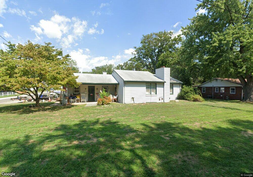
201 High St Maple Shade, NJ 08052
Estimated Value: $301,885 - $380,000
Studio
--
Bath
1,615
Sq Ft
$205/Sq Ft
Est. Value
About This Home
This home is located at 201 High St, Maple Shade, NJ 08052 and is currently estimated at $331,471, approximately $205 per square foot. 201 High St is a home located in Burlington County with nearby schools including Ralph J Steinhauer Elementary School, Maude M. Wilkins Elementary School, and Howard R Yocum School.
Ownership History
Date
Name
Owned For
Owner Type
Purchase Details
Closed on
Feb 4, 2019
Sold by
Zawacki Frances and Zawacki Katherine
Bought by
Fried Sherri A and Zawacki Irrevocable Trust
Current Estimated Value
Purchase Details
Closed on
Feb 20, 2016
Sold by
Zawacki Frances
Bought by
Zawacki Frances and Zawacki Katherine
Home Financials for this Owner
Home Financials are based on the most recent Mortgage that was taken out on this home.
Interest Rate
3.65%
Create a Home Valuation Report for This Property
The Home Valuation Report is an in-depth analysis detailing your home's value as well as a comparison with similar homes in the area
Home Values in the Area
Average Home Value in this Area
Purchase History
| Date | Buyer | Sale Price | Title Company |
|---|---|---|---|
| Fried Sherri A | -- | None Available | |
| Zawacki Frances | -- | -- |
Source: Public Records
Mortgage History
| Date | Status | Borrower | Loan Amount |
|---|---|---|---|
| Closed | Zawacki Frances | -- | |
| Previous Owner | Zawacki Frances | $50,000 | |
| Previous Owner | Zawacki Frances | $28,149 |
Source: Public Records
Tax History
| Year | Tax Paid | Tax Assessment Tax Assessment Total Assessment is a certain percentage of the fair market value that is determined by local assessors to be the total taxable value of land and additions on the property. | Land | Improvement |
|---|---|---|---|---|
| 2025 | $6,894 | $181,600 | $59,400 | $122,200 |
| 2024 | $6,694 | $181,600 | $59,400 | $122,200 |
| 2023 | $6,694 | $181,600 | $59,400 | $122,200 |
| 2022 | $6,590 | $181,600 | $59,400 | $122,200 |
| 2021 | $6,277 | $181,600 | $59,400 | $122,200 |
| 2020 | $6,545 | $181,600 | $59,400 | $122,200 |
| 2019 | $6,305 | $181,600 | $59,400 | $122,200 |
| 2018 | $6,196 | $181,600 | $59,400 | $122,200 |
| 2017 | $5,874 | $181,600 | $59,400 | $122,200 |
| 2016 | $5,783 | $181,600 | $59,400 | $122,200 |
| 2015 | $5,652 | $181,600 | $59,400 | $122,200 |
| 2014 | $5,722 | $181,600 | $59,400 | $122,200 |
Source: Public Records
Map
Nearby Homes
- 5 Exeter Place
- 27 Indian Queen Ln
- 400 N Forklanding Rd
- 728 Haverford Ave
- 331 Collins Ln
- 712 E Woodlawn Ave
- 2819 Haddonfield Rd
- 20 Kohlmyer Dr
- 21 Kohlmyer Dr
- 207 E Park Ave
- 3444 New Jersey Ave
- 411 A3 Stiles Ave Unit A-3
- 411 C12 Stiles Ave Unit C-12
- 411 A2 Stiles Ave Unit A-2
- 18 Hamilton Ct
- 2414 Church Rd
- 8661 Wyndam Rd
- 22 Theodore Ave
- 8315 Stockton Ave
- 8539 Bryn Mawr Ave
Your Personal Tour Guide
Ask me questions while you tour the home.