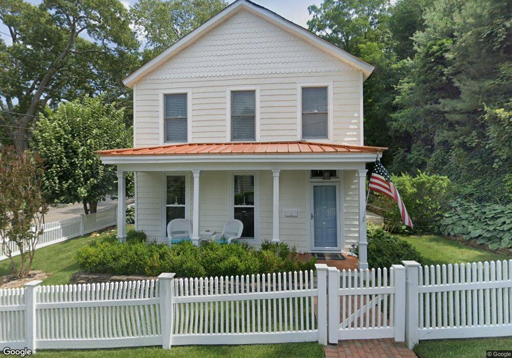
201 High St Port Jefferson, NY 11777
Estimated Value: $518,182 - $747,000
--
Bed
--
Bath
1,385
Sq Ft
$457/Sq Ft
Est. Value
About This Home
This home is located at 201 High St, Port Jefferson, NY 11777 and is currently estimated at $632,591, approximately $456 per square foot. 201 High St is a home located in Suffolk County with nearby schools including Edna Louise Spear Elementary, Port Jefferson Middle School, and Earl L Vandermeulen High School.
Ownership History
Date
Name
Owned For
Owner Type
Purchase Details
Closed on
Apr 24, 2024
Sold by
Rouse John and Rouse Barbara L
Bought by
J H & Barbara Rouse Irt and Liso
Current Estimated Value
Purchase Details
Closed on
Nov 14, 2020
Sold by
Rouse John
Bought by
Rouse John and Rouse Barbara L
Purchase Details
Closed on
May 30, 2017
Sold by
Kilgore William B and Hubbard Lauren I
Bought by
Rouse John
Home Financials for this Owner
Home Financials are based on the most recent Mortgage that was taken out on this home.
Original Mortgage
$195,000
Interest Rate
4.03%
Mortgage Type
New Conventional
Purchase Details
Closed on
Jul 22, 1999
Sold by
Planos Barbara and Stosuy Barbara
Bought by
Kilgore William B and Hubbard Lauren I
Create a Home Valuation Report for This Property
The Home Valuation Report is an in-depth analysis detailing your home's value as well as a comparison with similar homes in the area
Home Values in the Area
Average Home Value in this Area
Purchase History
| Date | Buyer | Sale Price | Title Company |
|---|---|---|---|
| J H & Barbara Rouse Irt | -- | None Available | |
| J H & Barbara Rouse Irt | -- | None Available | |
| Rouse John | -- | None Available | |
| Rouse John | -- | None Available | |
| Rouse John | $482,000 | None Available | |
| Rouse John | $482,000 | None Available | |
| Kilgore William B | $235,000 | Commonwealth Land Title Ins | |
| Kilgore William B | $235,000 | Commonwealth Land Title Ins |
Source: Public Records
Mortgage History
| Date | Status | Borrower | Loan Amount |
|---|---|---|---|
| Previous Owner | Rouse John | $195,000 |
Source: Public Records
Tax History Compared to Growth
Tax History
| Year | Tax Paid | Tax Assessment Tax Assessment Total Assessment is a certain percentage of the fair market value that is determined by local assessors to be the total taxable value of land and additions on the property. | Land | Improvement |
|---|---|---|---|---|
| 2024 | $4,906 | $1,550 | $550 | $1,000 |
| 2023 | $4,906 | $1,550 | $550 | $1,000 |
| 2022 | $3,655 | $1,550 | $550 | $1,000 |
| 2021 | $3,655 | $1,550 | $550 | $1,000 |
| 2020 | $4,419 | $1,550 | $550 | $1,000 |
| 2019 | $4,402 | $0 | $0 | $0 |
| 2018 | $2,880 | $1,550 | $550 | $1,000 |
| 2017 | $2,880 | $1,550 | $550 | $1,000 |
| 2016 | $2,887 | $1,550 | $550 | $1,000 |
| 2015 | -- | $1,550 | $550 | $1,000 |
| 2014 | -- | $1,550 | $550 | $1,000 |
Source: Public Records
Map
Nearby Homes
- 111 Campbell St
- 110 E Broadway
- 201 E Broadway
- 303 E Main St
- 125 Bleeker St
- 109 Spring St
- 515 High St Unit 17
- 319 Thompson St
- 1 Oakwood Rd
- 127 Barnum Ave
- 0 Bell Cir
- 330 E Broadway
- 18 Bell Cir
- 0 Belle Terre Rd
- 5 Princess Tree Ct
- 22 Saints Orchard Rd
- 204 Chestnut St
- 39 Cliff Rd
- 0 Saints Orchard Rd
- 1 Uva Way