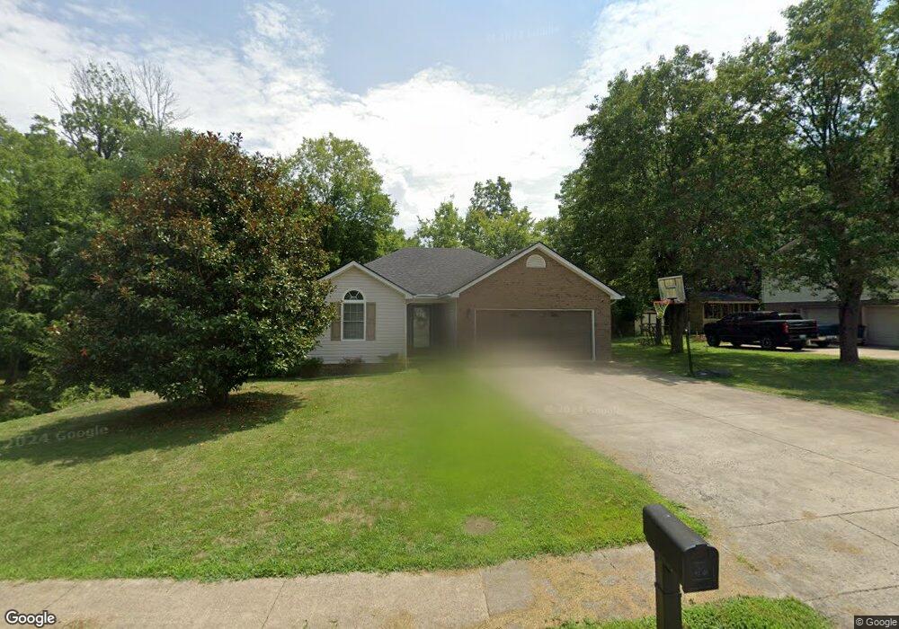
201 Humston Dr Lawrenceburg, KY 40342
Estimated Value: $232,000 - $267,000
3
Beds
2
Baths
1,280
Sq Ft
$191/Sq Ft
Est. Value
About This Home
This home is located at 201 Humston Dr, Lawrenceburg, KY 40342 and is currently estimated at $243,956, approximately $190 per square foot. 201 Humston Dr is a home located in Anderson County with nearby schools including Saffell Street Elementary School, Anderson County Middle School, and Anderson County High School.
Ownership History
Date
Name
Owned For
Owner Type
Purchase Details
Closed on
Dec 4, 2018
Sold by
Jordan Walter T and Jordan Jill P
Bought by
Walter T Jordan and Jordan Revocable Living Trust
Current Estimated Value
Purchase Details
Closed on
Oct 22, 2012
Sold by
Federal Home Loan Mortgage Corporation
Bought by
Jordan Jill
Purchase Details
Closed on
Apr 10, 2012
Sold by
Jp Morgan Chase Bank
Bought by
Jp Morgan Chase Bank and Chase Home Loan Mortgage
Create a Home Valuation Report for This Property
The Home Valuation Report is an in-depth analysis detailing your home's value as well as a comparison with similar homes in the area
Home Values in the Area
Average Home Value in this Area
Purchase History
| Date | Buyer | Sale Price | Title Company |
|---|---|---|---|
| Walter T Jordan | -- | None Available | |
| Jordan Jill | $92,000 | -- | |
| Jp Morgan Chase Bank | $76,667 | -- |
Source: Public Records
Tax History Compared to Growth
Tax History
| Year | Tax Paid | Tax Assessment Tax Assessment Total Assessment is a certain percentage of the fair market value that is determined by local assessors to be the total taxable value of land and additions on the property. | Land | Improvement |
|---|---|---|---|---|
| 2024 | $1,347 | $145,000 | $22,000 | $123,000 |
| 2023 | $1,367 | $145,000 | $22,000 | $123,000 |
| 2022 | $1,255 | $130,000 | $22,000 | $108,000 |
| 2021 | $1,188 | $120,000 | $22,000 | $98,000 |
| 2020 | $1,219 | $120,000 | $22,000 | $98,000 |
| 2019 | $1,239 | $120,000 | $22,000 | $98,000 |
| 2018 | $1,125 | $110,000 | $22,000 | $88,000 |
| 2017 | $1,105 | $110,000 | $22,000 | $88,000 |
| 2016 | $1,087 | $110,000 | $22,000 | $88,000 |
| 2015 | $1,063 | $110,000 | $22,000 | $88,000 |
| 2014 | $1,060 | $110,000 | $22,000 | $88,000 |
| 2013 | $874 | $92,000 | $22,000 | $70,000 |
Source: Public Records
Map
Nearby Homes
- 205 Lynn Dr
- 417 Humston Dr
- 406 Forrest Dr
- 213 Horn Dr
- 56 Ann Dr
- 200 W End Dr
- 108 Brenda Dr
- 105 Whitney Ave
- 101 Whitney Ave
- 220 Forrest Dr
- 1001 Bypass Hwy N
- 1011 Bypass Hwy N
- 1007 Bypass Hwy N
- 1003 Bypass Hwy N
- 1005 Bypass Hwy N
- 1301-2 Glensboro Rd
- 410 Greenview Dr
- 3012 Briarcreek Dr
- Lot #1 Briarcreek Dr
- 3020 Thorntree Ln
- 205 Humston Dr
- 209 Humston Dr
- 217 Humston Dr
- 311 Humston Dr Unit 309
- 308 Humston Dr Unit 310
- 332 Humston Dr Unit 334
- 324 Humston Dr Unit 326
- 336 Humston Dr
- 304 Humston Dr Unit 306
- 312 Humston Dr Unit 314
- 308 Humston-309
- 316 Humston Dr Unit 318
- 501 Chaucer Dr
- 216 Whitney Ave
- 321 Humston Dr Unit 323
- 214 Whitney Ave
- 509 Chaucer Dr
- 505 Chaucer Dr
- 513 Chaucer Ct
- 212 Whitney Ave