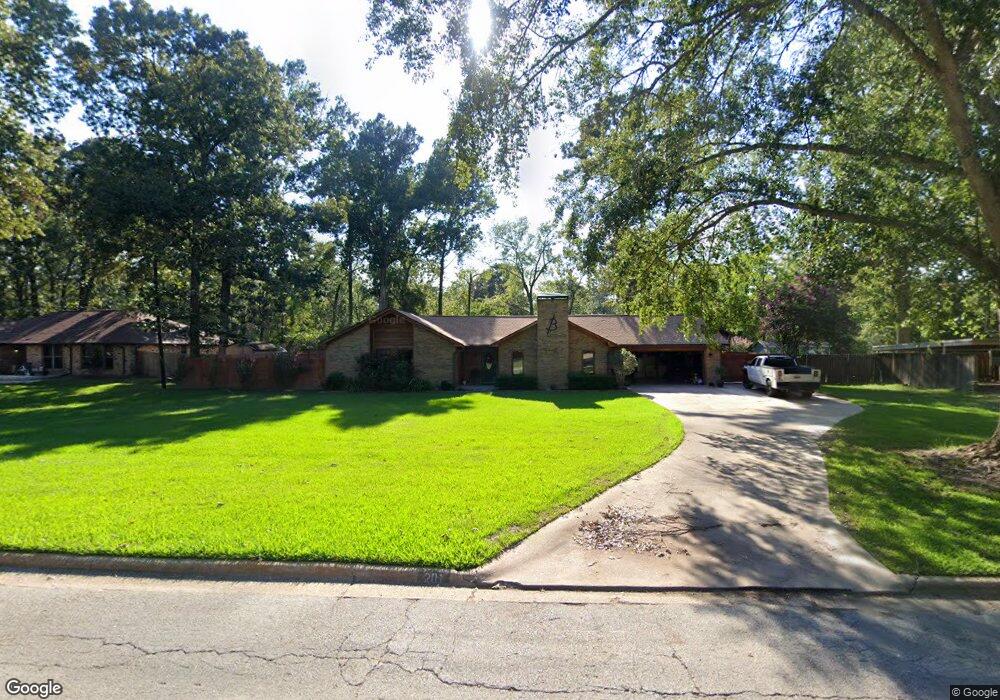
201 Karen Dr Lufkin, TX 75901
Estimated Value: $253,426 - $313,000
3
Beds
2
Baths
1,783
Sq Ft
$158/Sq Ft
Est. Value
About This Home
This home is located at 201 Karen Dr, Lufkin, TX 75901 and is currently estimated at $281,357, approximately $157 per square foot. 201 Karen Dr is a home located in Angelina County with nearby schools including Kurth Primary School, Anderson Elementary School, and Lufkin Middle School.
Ownership History
Date
Name
Owned For
Owner Type
Purchase Details
Closed on
Dec 3, 2024
Sold by
Blackwood Marianne Nelson
Bought by
Blackwood Tiffany and Blackwood James
Current Estimated Value
Purchase Details
Closed on
Jul 2, 2020
Sold by
Dunn James Ray and Dunn Deborah
Bought by
Blackwood James
Purchase Details
Closed on
Feb 5, 2015
Sold by
Paxson Thomas L and Paxson Janis Anderson
Bought by
Blackwood James R and Blackwood Jeff W
Purchase Details
Closed on
May 25, 2007
Sold by
Crawford Dirk Jason and Crawford Lori Ann
Bought by
Blackwood James and Blackwood Tiffany
Home Financials for this Owner
Home Financials are based on the most recent Mortgage that was taken out on this home.
Original Mortgage
$132,000
Interest Rate
6.22%
Mortgage Type
New Conventional
Create a Home Valuation Report for This Property
The Home Valuation Report is an in-depth analysis detailing your home's value as well as a comparison with similar homes in the area
Home Values in the Area
Average Home Value in this Area
Purchase History
| Date | Buyer | Sale Price | Title Company |
|---|---|---|---|
| Blackwood Tiffany | -- | None Listed On Document | |
| Blackwood James | -- | Community Title | |
| Blackwood James R | -- | None Available | |
| Blackwood James | -- | Community Title Company |
Source: Public Records
Mortgage History
| Date | Status | Borrower | Loan Amount |
|---|---|---|---|
| Previous Owner | Blackwood James | $132,000 |
Source: Public Records
Tax History Compared to Growth
Tax History
| Year | Tax Paid | Tax Assessment Tax Assessment Total Assessment is a certain percentage of the fair market value that is determined by local assessors to be the total taxable value of land and additions on the property. | Land | Improvement |
|---|---|---|---|---|
| 2025 | $5,025 | $240,450 | $23,000 | $217,450 |
| 2024 | $4,768 | $235,670 | $23,000 | $212,670 |
| 2023 | $4,122 | $232,510 | $23,000 | $209,510 |
| 2022 | $4,295 | $209,710 | $15,840 | $193,870 |
| 2021 | $4,223 | $176,280 | $15,840 | $160,440 |
| 2020 | $3,830 | $155,850 | $15,840 | $140,010 |
| 2019 | $4,103 | $157,840 | $15,840 | $142,000 |
| 2018 | $3,213 | $153,310 | $15,840 | $137,470 |
| 2017 | $3,213 | $147,480 | $15,840 | $131,640 |
| 2016 | $3,430 | $143,880 | $15,840 | $128,040 |
| 2015 | $3,226 | $143,880 | $15,840 | $128,040 |
| 2014 | $3,226 | $143,160 | $15,840 | $127,320 |
Source: Public Records
Map
Nearby Homes
- R33234 Platt Rd
- 1502 Brentwood Dr
- 410 Brentwood Dr
- 502 Brentwood Dr
- 2608 Tulane Dr
- 2102 Brentwood Dr
- 2540 Brentwood Dr
- 2104 Brentwood Dr
- 510 Brentwood Dr
- R33219, R33220 Brentwood Dr
- 110 Copperwood Loop
- 101 Southern Trace Dr
- 508 Forest Creek Dr
- 406 Forest Creek Dr
- 1302 Parkman St
- 12 Windsor Ct
- 5100 Farm To Market 58