
Seller's Agent in 2025
Josh Behr
Keller Williams Realty - Washington Township
(856) 470-7667
2 in this area
200 Total Sales
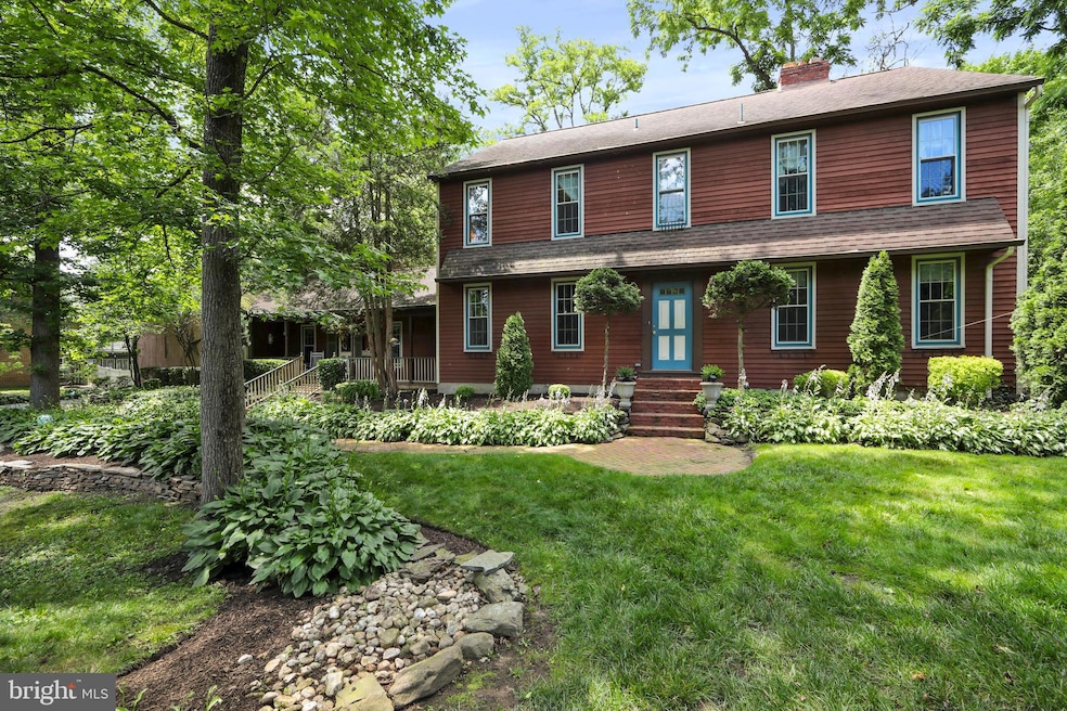
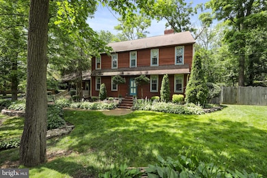
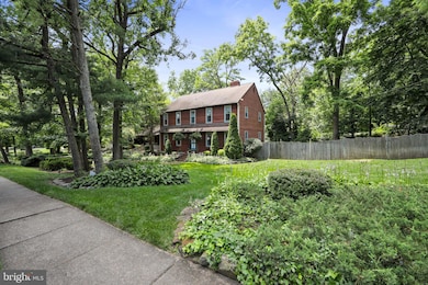
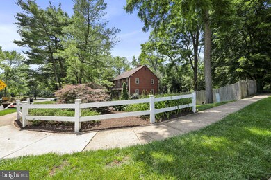
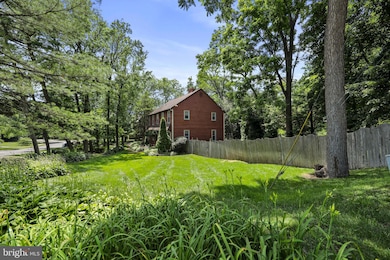
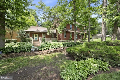
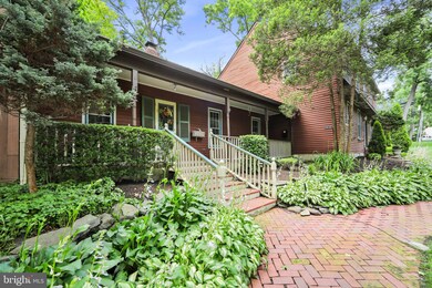
WOW! This is a must see 4 Bedroom, 4.5 Bathroom Colonial Home in much desired Moorestown, NJ. Upon pulling up to your new home, take notice of the Lovely Landscaping, the 6-Car Driveway, the 2-Car Garage, the Beautiful Brick Walkway, and the Covered Front Porch. This home comes with 2 Front Entrances. Head in through the Main Front Door and into the Foyer. To the right, is the Office with Hardwood Floors, a Floor to Ceiling Brick Wood-Burning Fireplace, and Custom Built-In Bookshelves. To the left, is the Formal Dining Room with Hardwood Floors, Wonderful Wainscoting, a Chair-Rail, and Crown Molding. Right off the Foyer is the Powder Room. Next, you are led into the heart of the home, the Tastefully Updated Eat-In Kitchen featuring Hardwood Floors, Plenty of Wood Cabinets including some Glass Paneled Cabinet Doors, Gorgeous Granite Countertops, a Tile Backsplash, Recessed Lighting, a Desk Area, a Large Center Island including a Built-In Sink & Cooktop, as well as Seating for 5, a 2nd Big Sink, and a Double Wall Oven. The Living Room sits right off of the Open Kitchen and comes with Hardwood Floors, a Brick Wood-Burning Fireplace, Built-In Bookshelves, and Crown Molding. You will love the Fantastic Family Room which sits right off of the Kitchen as well, and comes with a Vaulted Ceiling, Hardwood Floors, a Built-In Bookshelf, a Stunning Stone Fireplace with a Mantle, and a Glass Paneled Door leading you out back. Your 1st Floor also comes with the 2nd Front Door entrance, a Mudroom with a Laundry Closet and Storage Closet, a door leading into the 2-Car Garage, the 3rd Full Bathroom, and the 4th Bedroom with Bonus Room that can be used as a Sitting Room or an Additional Office. As you wander upstairs, head into the Primary Bedroom Suite with Hardwood Floors, Custom Decorative Wood Walls and Ceiling, a 5x6 Walk-In Closet, a 2nd Custom 10x15 Walk-In Closet, and your own Updated Full Bathroom. Down the hall is the 2nd & 3rd Bedrooms, both with Hardwood Flooring and Big Closets. The 2nd Updated Amazing Full Bathroom, a Large Storage Closet, a Linen Closet, and Pull down stairs to the attic complete the 2nd Floor. Need more space? Head down to the Finished Basement. Here you will find 2 Large Finished Rooms, the 4th Full Bathroom, the Workshop/Utility Room, and the Custom Wine Room. Your Wine Room boasts Custom Built-In Wine Storage Racks/Shelves, and Holders, as well as 2 Storage Closets. I saved the best for last, the Backyard Oasis. Your Backyard comes with a Huge Screened-In and Covered Back Wood Deck, a Heated In-Ground Gunite Pool with a Built-In Jacuzzi, Plenty of Stamped Concrete Pool Decking, and Luscious Landscaping. Don't miss the opportunity to make this your home today. This home is being sold in as-is condition.
Last Agent to Sell the Property
(856) 470-7667 josh@soldbybehr.com Keller Williams Realty - Washington Township License #1324995 Listed on: 06/20/2025
Last Buyer's Agent
(856) 297-6827 sam@samlepore.com Keller Williams Realty - Moorestown License #RS355976
| Date | Type | Sale Price | Title Company |
|---|---|---|---|
| Deed | -- | -- |
| Date | Event | Price | List to Sale | Price per Sq Ft |
|---|---|---|---|---|
| 10/28/2025 10/28/25 | Sold | $825,000 | -5.7% | $214 / Sq Ft |
| 08/26/2025 08/26/25 | Pending | -- | -- | -- |
| 07/03/2025 07/03/25 | Price Changed | $875,000 | -5.4% | $227 / Sq Ft |
| 06/20/2025 06/20/25 | For Sale | $925,000 | -- | $240 / Sq Ft |
| Year | Tax Paid | Tax Assessment Tax Assessment Total Assessment is a certain percentage of the fair market value that is determined by local assessors to be the total taxable value of land and additions on the property. | Land | Improvement |
|---|---|---|---|---|
| 2025 | $16,052 | $565,800 | $181,600 | $384,200 |
| 2024 | $15,565 | $565,800 | $181,600 | $384,200 |
| 2023 | $15,565 | $565,800 | $181,600 | $384,200 |
| 2022 | $15,407 | $565,800 | $181,600 | $384,200 |
| 2021 | $14,203 | $565,800 | $181,600 | $384,200 |
| 2020 | $15,107 | $565,800 | $181,600 | $384,200 |
| 2019 | $14,841 | $565,800 | $181,600 | $384,200 |
| 2018 | $14,439 | $565,800 | $181,600 | $384,200 |
| 2017 | $14,564 | $565,800 | $181,600 | $384,200 |
| 2016 | $14,513 | $565,800 | $181,600 | $384,200 |
| 2015 | $14,337 | $565,800 | $181,600 | $384,200 |
| 2014 | $13,613 | $565,800 | $181,600 | $384,200 |
Seller's Agent in 2025
Josh Behr
Keller Williams Realty - Washington Township
(856) 470-7667
2 in this area
200 Total Sales
Buyer's Agent in 2025
Sam Lepore
Keller Williams Realty - Moorestown
(856) 297-6827
140 in this area
659 Total Sales
Source: Bright MLS
MLS Number: NJBL2089760
APN: 22-04900-0000-00015
Disclaimer: Certain information contained herein is derived from information provided by parties other than Homes.com. All information provided is deemed reliable, but is not guaranteed to be accurate and should be independently verified.
![]() The data relating to real estate for sale on this website appears in part through the BRIGHT Internet Data Exchange program, a voluntary cooperative exchange of property listing data between licensed real estate brokerage firms, and is provided by BRIGHT through a licensing agreement.
The data relating to real estate for sale on this website appears in part through the BRIGHT Internet Data Exchange program, a voluntary cooperative exchange of property listing data between licensed real estate brokerage firms, and is provided by BRIGHT through a licensing agreement.
Listing information is from various brokers who participate in the Bright MLS IDX program and not all listings may be visible on the site.
The property information being provided on or through the website is for the personal, non-commercial use of consumers and such information may not be used for any purpose other than to identify prospective properties consumers may be interested in purchasing.
Some properties which appear for sale on the website may no longer be available because they are for instance, under contract, sold or are no longer being offered for sale.
Property information displayed is deemed reliable but is not guaranteed.
Copyright 2025 Bright MLS, Inc.