
Seller's Agent in 2025
Valerie Bertsch
Compass New Jersey, LLC - Moorestown
(609) 410-1763
14 in this area
188 Total Sales

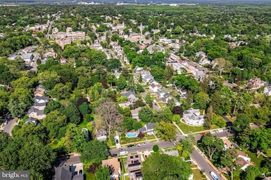
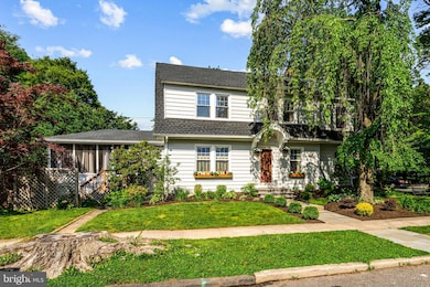

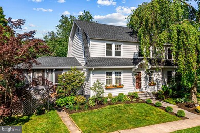
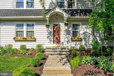
***Highest and Best due Thursday 6/19 by noon. ***Welcome to 201 Locust Street, a truly special home that perfectly captures the charm, character, and community spirit of Moorestown, New Jersey. This lovingly maintained Colonial is nestled on a desirable tree-lined corner lot just blocks from the heart of downtown, offering a rare combination of timeless architecture, thoughtful updates, and an unbeatable location. Boasting 4 spacious bedrooms, 2.5 bathrooms, and nearly 1,900 square feet of living space, this home has been meticulously cared for and is ready to welcome its next chapter.
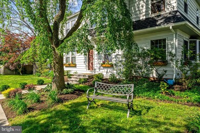
As you approach, you'll be immediately drawn in by the classic curb appeal, beautiful landscaping and the welcoming weeping willow. Step through the front door and into a sun-drenched entry where original hardwood floors run throughout the main level, creating a sense of continuity and elegance. The living room is anchored by a beautiful wood-burning fireplace and offers the perfect space for cozy evenings, quiet mornings, or lively gatherings with friends and family. High ceilings and oversized windows fill the room with natural light, while tasteful architectural details like crown molding and built-in shelving enhance the home’s historic character.
Adjacent to the living room is a formal dining area that can easily accommodate large holiday dinners or intimate meals. The flow between the living and dining spaces is ideal for entertaining and connects seamlessly to the kitchen, which has been thoughtfully updated with stainless steel appliances, ample cabinet space, sleek countertops, and a convenient butler’s pantry that provides additional storage and prep space. Whether you're preparing a quick breakfast or a multi-course dinner, this kitchen is equipped to meet your every need.
Upstairs, the primary bedroom suite offers a serene escape with generous closet space and a private en-suite bathroom. Three additional bedrooms provide comfortable accommodations for family members, guests, or flexible use as a home office, fitness area, or creative studio. A second full bathroom serves these bedrooms, with tasteful tile work and classic finishes that echo the home's traditional roots while offering modern function.
One of the true highlights of 201 Locust Street is the screened-in porch at the back of the home—an ideal spot for 3-season enjoyment. Whether you’re sipping coffee on a spring morning, hosting a summer dinner party, or simply relaxing in the shade with a good book, this space offers comfort, privacy, and a peaceful view of the backyard. Step outside and you'll find a beautifully maintained yard with mature trees, garden beds, and a refreshing in-ground pool—the perfect centerpiece for summer fun and entertaining. The yard is fully fenced, offering both privacy and peace of mind for kids or pets to play safely. A detached one-car garage with additional storage completes the outdoor space.
Located within walking distance to the shops, restaurants, and cultural landmarks of Moorestown's charming Main Street, this home offers the perfect blend of small-town atmosphere and everyday convenience. Top-rated public schools, nearby parks, and easy access to major highways and Philadelphia make this location as practical as it is desirable. Whether you’re looking for a family-friendly neighborhood, a welcoming community, or a place to put down roots in a town steeped in history and charm, 201 Locust Street delivers on all fronts.
This is more than just a house—it’s a home where memories are made, milestones are celebrated, and every detail has been lovingly cared for. With its combination of style, comfort, and location, this property represents a unique opportunity to own a piece of Moorestown’s storied past while enjoying all the modern amenities of today. Schedule your showing and come experience the warmth and charm of 201 Locust Street for yourself. You won’t want to leave. Pool and detached garage in "as is" condition.
Last Agent to Sell the Property
(856) 214-2639 camilo.concepcion@compass.com Compass New Jersey, LLC - Moorestown Listed on: 06/14/2025
Last Buyer's Agent
(856) 214-2639 camilo.concepcion@compass.com Compass New Jersey, LLC - Moorestown License #335983
| Date | Type | Sale Price | Title Company |
|---|---|---|---|
| Bargain Sale Deed | $731,201 | Foundation Title | |
| Bargain Sale Deed | $325,000 | Foundation Title | |
| Deed | $300,000 | Surety Title Corporation | |
| Bargain Sale Deed | $251,000 | Nia Lawyers Title Agency | |
| Deed | $210,000 | -- |
| Date | Status | Loan Amount | Loan Type |
|---|---|---|---|
| Open | $475,281 | New Conventional | |
| Previous Owner | $308,750 | New Conventional | |
| Previous Owner | $240,000 | Purchase Money Mortgage | |
| Previous Owner | $25,100 | Credit Line Revolving | |
| Previous Owner | $200,800 | No Value Available | |
| Previous Owner | $189,000 | No Value Available |
| Date | Event | Price | List to Sale | Price per Sq Ft |
|---|---|---|---|---|
| 08/25/2025 08/25/25 | Sold | $731,201 | +4.6% | $386 / Sq Ft |
| 06/21/2025 06/21/25 | Pending | -- | -- | -- |
| 06/14/2025 06/14/25 | For Sale | $699,000 | -- | $369 / Sq Ft |
| Year | Tax Paid | Tax Assessment Tax Assessment Total Assessment is a certain percentage of the fair market value that is determined by local assessors to be the total taxable value of land and additions on the property. | Land | Improvement |
|---|---|---|---|---|
| 2025 | $7,050 | $248,500 | $107,300 | $141,200 |
| 2024 | $6,836 | $248,500 | $107,300 | $141,200 |
| 2023 | $6,836 | $248,500 | $107,300 | $141,200 |
| 2022 | $6,767 | $248,500 | $107,300 | $141,200 |
| 2021 | $6,677 | $248,500 | $107,300 | $141,200 |
| 2020 | $6,635 | $248,500 | $107,300 | $141,200 |
| 2019 | $6,518 | $248,500 | $107,300 | $141,200 |
| 2018 | $6,342 | $248,500 | $107,300 | $141,200 |
| 2017 | $6,396 | $248,500 | $107,300 | $141,200 |
| 2016 | $6,374 | $248,500 | $107,300 | $141,200 |
| 2015 | $6,297 | $248,500 | $107,300 | $141,200 |
| 2014 | $5,979 | $248,500 | $107,300 | $141,200 |
Seller's Agent in 2025
Valerie Bertsch
Compass New Jersey, LLC - Moorestown
(609) 410-1763
14 in this area
188 Total Sales
Buyer's Agent in 2025
Lorna Kaim
Compass New Jersey, LLC - Moorestown
(856) 986-2642
9 in this area
98 Total Sales
Source: Bright MLS
MLS Number: NJBL2089230
APN: 22-02401-0000-00026
Disclaimer: Certain information contained herein is derived from information provided by parties other than Homes.com. All information provided is deemed reliable, but is not guaranteed to be accurate and should be independently verified.
![]() The data relating to real estate for sale on this website appears in part through the BRIGHT Internet Data Exchange program, a voluntary cooperative exchange of property listing data between licensed real estate brokerage firms, and is provided by BRIGHT through a licensing agreement.
The data relating to real estate for sale on this website appears in part through the BRIGHT Internet Data Exchange program, a voluntary cooperative exchange of property listing data between licensed real estate brokerage firms, and is provided by BRIGHT through a licensing agreement.
Listing information is from various brokers who participate in the Bright MLS IDX program and not all listings may be visible on the site.
The property information being provided on or through the website is for the personal, non-commercial use of consumers and such information may not be used for any purpose other than to identify prospective properties consumers may be interested in purchasing.
Some properties which appear for sale on the website may no longer be available because they are for instance, under contract, sold or are no longer being offered for sale.
Property information displayed is deemed reliable but is not guaranteed.
Copyright 2026 Bright MLS, Inc.
Ask me questions while you tour the home.