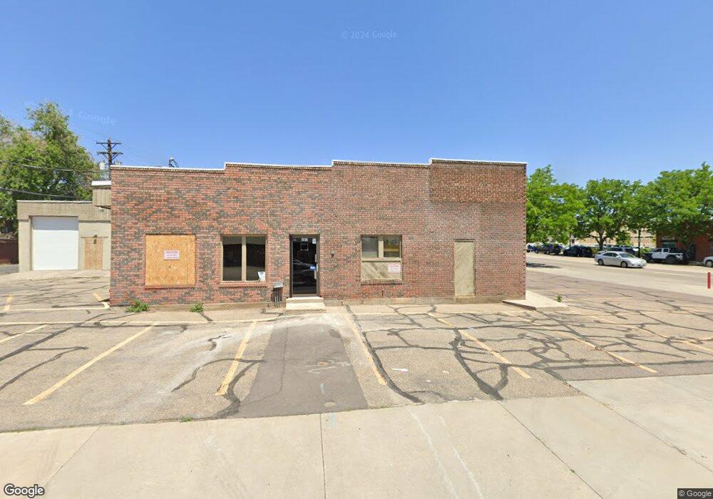
201 Main St Longmont, CO 80501
Business District NeighborhoodEstimated Value: $916,792
Studio
--
Bath
5,055
Sq Ft
$181/Sq Ft
Est. Value
About This Home
This home is located at 201 Main St, Longmont, CO 80501 and is currently estimated at $916,792, approximately $181 per square foot. 201 Main St is a home located in Boulder County with nearby schools including Central Elementary School, Westview Middle School, and Longmont High School.
Ownership History
Date
Name
Owned For
Owner Type
Purchase Details
Closed on
May 8, 2013
Sold by
Marx Family Llc
Bought by
2Nd & Main Llc
Current Estimated Value
Home Financials for this Owner
Home Financials are based on the most recent Mortgage that was taken out on this home.
Original Mortgage
$340,000
Outstanding Balance
$239,039
Interest Rate
3.61%
Mortgage Type
Commercial
Estimated Equity
$677,753
Purchase Details
Closed on
May 30, 1996
Sold by
Roddy William J and Roddy Joyce M
Bought by
Roddy William E
Home Financials for this Owner
Home Financials are based on the most recent Mortgage that was taken out on this home.
Original Mortgage
$86,700
Interest Rate
7.93%
Mortgage Type
Commercial
Purchase Details
Closed on
Oct 17, 1985
Bought by
2Nd And Main Llc
Purchase Details
Closed on
Oct 21, 1982
Bought by
2Nd And Main Llc
Purchase Details
Closed on
Jun 7, 1979
Bought by
2Nd And Main Llc
Create a Home Valuation Report for This Property
The Home Valuation Report is an in-depth analysis detailing your home's value as well as a comparison with similar homes in the area
Home Values in the Area
Average Home Value in this Area
Purchase History
| Date | Buyer | Sale Price | Title Company |
|---|---|---|---|
| 2Nd & Main Llc | $425,000 | Empire Title Co Springs Llc | |
| Roddy William E | $85,000 | Empire Title & Escrow | |
| 2Nd And Main Llc | -- | -- | |
| 2Nd And Main Llc | -- | -- | |
| 2Nd And Main Llc | -- | -- |
Source: Public Records
Mortgage History
| Date | Status | Borrower | Loan Amount |
|---|---|---|---|
| Open | 2Nd & Main Llc | $340,000 | |
| Previous Owner | Roddy William E | $86,700 |
Source: Public Records
Tax History
| Year | Tax Paid | Tax Assessment Tax Assessment Total Assessment is a certain percentage of the fair market value that is determined by local assessors to be the total taxable value of land and additions on the property. | Land | Improvement |
|---|---|---|---|---|
| 2025 | $23,039 | $264,384 | $106,461 | $157,923 |
| 2024 | $23,039 | $264,384 | $106,461 | $157,923 |
| 2023 | $22,741 | $228,892 | $105,574 | $131,688 |
| 2022 | $15,963 | $153,555 | $58,580 | $94,975 |
| 2021 | $15,729 | $153,555 | $58,580 | $94,975 |
| 2020 | $15,640 | $153,120 | $58,580 | $94,540 |
| 2019 | $15,405 | $153,120 | $58,580 | $94,540 |
| 2018 | $15,865 | $158,674 | $79,866 | $78,808 |
| 2017 | $13,189 | $217,123 | $79,866 | $137,257 |
| 2016 | $6,568 | $125,570 | $30,138 | $95,432 |
| 2015 | $6,274 | $101,065 | $26,912 | $74,153 |
| 2014 | $5,122 | $101,065 | $26,912 | $74,153 |
Source: Public Records
Map
Nearby Homes
- 226 Pratt St Unit 226
- 201 Pratt St
- 831 4th Ave
- 409 Terry St Unit B
- 318 4th Ave
- 400 Emery St Unit 202
- 120 Bowen St
- 422 Atwood St
- 619 Pratt St
- 536 Atwood St
- 8 Elizabeth Ct
- 36 Reed Place
- 7 6th Ave
- 104 Rothrock Place
- 304 Barnard Ct
- 820 Kimbark St Unit B
- 725 Gay St
- 316 Barnard Ct Unit 87
- 406 Sunnyside Ln
- 128 E 5th Ave
- 640 2nd Ave Unit 1202
- 640 2nd Ave Unit 1307
- 640 2nd Ave Unit 905
- 025-241-34 Glen St
- 650 2nd Ave
- 204 Coffman St
- 206 Coffman St
- 200 Coffman St
- 214 Coffman St
- 137 Main St Unit 1
- 137 Main St
- 611 2nd Ave
- 611 2nd Ave Unit 200
- 202 Main St Unit 3
- 202 Main St
- 218 Coffman St
- 225 Main St
- 509 2nd Ave Unit 10
- 509 2nd Ave
- 150 Coffman St
Your Personal Tour Guide
Ask me questions while you tour the home.