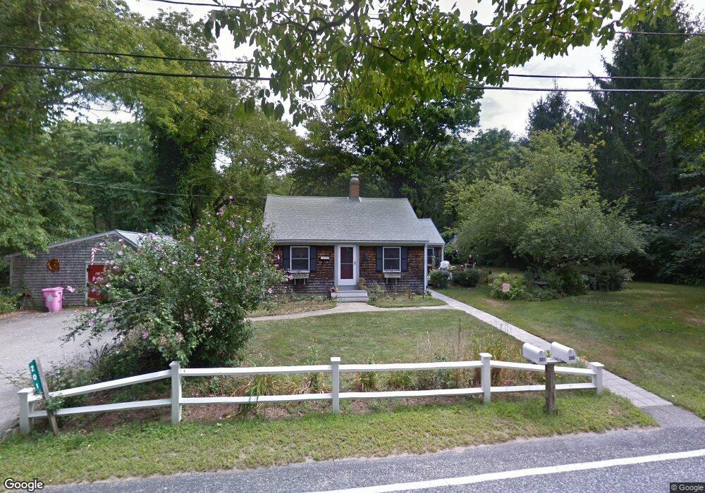
201 New St Rehoboth, MA 02769
Estimated Value: $456,068 - $491,000
3
Beds
1
Bath
1,446
Sq Ft
$332/Sq Ft
Est. Value
About This Home
This home is located at 201 New St, Rehoboth, MA 02769 and is currently estimated at $479,517, approximately $331 per square foot. 201 New St is a home located in Bristol County with nearby schools including Dighton-Rehoboth Regional High School and Cedar Brook School.
Ownership History
Date
Name
Owned For
Owner Type
Purchase Details
Closed on
Jun 15, 2011
Sold by
Amaral Katheen
Bought by
201 New Street Rt and Amaral Kathleen
Current Estimated Value
Purchase Details
Closed on
Sep 19, 2007
Sold by
Amaral James L and Amaral Kathleen
Bought by
Amaral James L and Amaral Kathleen
Home Financials for this Owner
Home Financials are based on the most recent Mortgage that was taken out on this home.
Original Mortgage
$260,000
Interest Rate
6.63%
Mortgage Type
Purchase Money Mortgage
Purchase Details
Closed on
Aug 22, 2003
Sold by
Amaral James L and Amaral Kathleen
Bought by
Amaral James L and Amaral Kathleen
Purchase Details
Closed on
Mar 1, 1974
Bought by
Amaral Kathleen
Create a Home Valuation Report for This Property
The Home Valuation Report is an in-depth analysis detailing your home's value as well as a comparison with similar homes in the area
Home Values in the Area
Average Home Value in this Area
Purchase History
| Date | Buyer | Sale Price | Title Company |
|---|---|---|---|
| 201 New Street Rt | -- | -- | |
| Amaral James L | -- | -- | |
| Amaral James L | -- | -- | |
| Amaral Kathleen | -- | -- |
Source: Public Records
Mortgage History
| Date | Status | Borrower | Loan Amount |
|---|---|---|---|
| Previous Owner | Amaral Kathleen | $259,000 | |
| Previous Owner | Amaral James L | $260,000 | |
| Previous Owner | Amaral Kathleen | $85,000 | |
| Previous Owner | Amaral Kathleen | $35,000 |
Source: Public Records
Tax History Compared to Growth
Tax History
| Year | Tax Paid | Tax Assessment Tax Assessment Total Assessment is a certain percentage of the fair market value that is determined by local assessors to be the total taxable value of land and additions on the property. | Land | Improvement |
|---|---|---|---|---|
| 2025 | $38 | $342,200 | $174,600 | $167,600 |
| 2024 | $3,657 | $321,900 | $174,600 | $147,300 |
| 2023 | $3,685 | $318,200 | $171,200 | $147,000 |
| 2022 | $3,516 | $277,500 | $163,400 | $114,100 |
| 2021 | $6,760 | $265,300 | $148,100 | $117,200 |
| 2020 | $3,451 | $263,000 | $148,100 | $114,900 |
| 2018 | $2,882 | $240,800 | $141,200 | $99,600 |
| 2017 | $4,262 | $228,700 | $141,200 | $87,500 |
| 2016 | $2,702 | $222,400 | $141,200 | $81,200 |
| 2015 | $2,807 | $228,000 | $134,500 | $93,500 |
| 2014 | $2,676 | $215,100 | $128,200 | $86,900 |
Source: Public Records
Map
Nearby Homes
- 0 Horton St Unit 73333337
- 2661 Horton St
- 2713 Horton St
- 1030 Oak St
- 24 New St
- 1240 Smith St
- 133 Winthrop St
- 19 Cedar St Unit 21
- 225 Winthrop St
- 2045 Winthrop St
- 23 Bay State Rd
- 248 County
- 63 Moulton St
- 246 Winthrop St
- 0 Winthrop St Unit 73180872
- 0 Monteiro Unit 71870472
- 826 Williams St
- 10 Muriel Way
- 257 Anawan St
- 1421 Tremont St