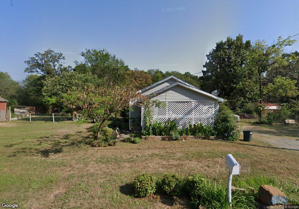
201 North Ave Poteau, OK 74953
Estimated Value: $58,327 - $97,000
3
Beds
1
Bath
1,100
Sq Ft
$70/Sq Ft
Est. Value
About This Home
This home is located at 201 North Ave, Poteau, OK 74953 and is currently estimated at $77,332, approximately $70 per square foot. 201 North Ave is a home located in Le Flore County with nearby schools including Poteau Primary Elementary School, Poteau Upper Elementary School, and Pansy Kidd Middle School.
Ownership History
Date
Name
Owned For
Owner Type
Purchase Details
Closed on
Oct 7, 2019
Sold by
Embrey Heath
Bought by
Felipe Haide
Current Estimated Value
Purchase Details
Closed on
Dec 7, 2018
Sold by
Embrey Heath
Bought by
Felipe Hoide
Home Financials for this Owner
Home Financials are based on the most recent Mortgage that was taken out on this home.
Original Mortgage
$8,000
Interest Rate
4.8%
Mortgage Type
Land Contract Argmt. Of Sale
Purchase Details
Closed on
Aug 11, 2010
Sold by
Reidy Mary
Bought by
Embrey Heath
Purchase Details
Closed on
Apr 20, 2009
Sold by
Howard Nancy and Howard Larry
Bought by
Reidy Mary
Create a Home Valuation Report for This Property
The Home Valuation Report is an in-depth analysis detailing your home's value as well as a comparison with similar homes in the area
Home Values in the Area
Average Home Value in this Area
Purchase History
| Date | Buyer | Sale Price | Title Company |
|---|---|---|---|
| Felipe Haide | $8,000 | None Available | |
| Felipe Hoide | $8,000 | None Available | |
| Embrey Heath | -- | -- | |
| Reidy Mary | -- | -- |
Source: Public Records
Mortgage History
| Date | Status | Borrower | Loan Amount |
|---|---|---|---|
| Previous Owner | Felipe Hoide | $8,000 |
Source: Public Records
Tax History Compared to Growth
Tax History
| Year | Tax Paid | Tax Assessment Tax Assessment Total Assessment is a certain percentage of the fair market value that is determined by local assessors to be the total taxable value of land and additions on the property. | Land | Improvement |
|---|---|---|---|---|
| 2025 | $157 | $1,844 | $660 | $1,184 |
| 2023 | $157 | $1,900 | $715 | $1,185 |
| 2022 | $162 | $1,809 | $715 | $1,094 |
| 2021 | $245 | $2,749 | $715 | $2,034 |
| 2020 | $246 | $2,749 | $715 | $2,034 |
| 2019 | $257 | $2,856 | $715 | $2,141 |
| 2018 | $261 | $3,064 | $715 | $2,349 |
| 2017 | $250 | $2,918 | $715 | $2,203 |
| 2016 | $236 | $2,779 | $715 | $2,064 |
| 2015 | $229 | $2,647 | $715 | $1,932 |
| 2014 | $220 | $2,521 | $715 | $1,806 |
Source: Public Records
Map
Nearby Homes
- 301 Turman St
- 516 Beeler St
- 207 Thompson Ave
- 301 Wilson Ave
- 104 Clark Ave
- 606 Torby Ave
- 104 Craigway St
- 204 Bowlin Dr
- 205 Bowlin Dr
- 701 N Witte St
- TBD Tract #1 Coggins Ave
- TBD Tract #2 Coggins Ave
- 000 Coggins Ave
- 307 Mission Dr
- 315 College Ave
- TBD Mission Dr
- 206 Green Ave
- 2104 N Broadway St Unit b
- 308 Peters St
- 200 Franzini Dr