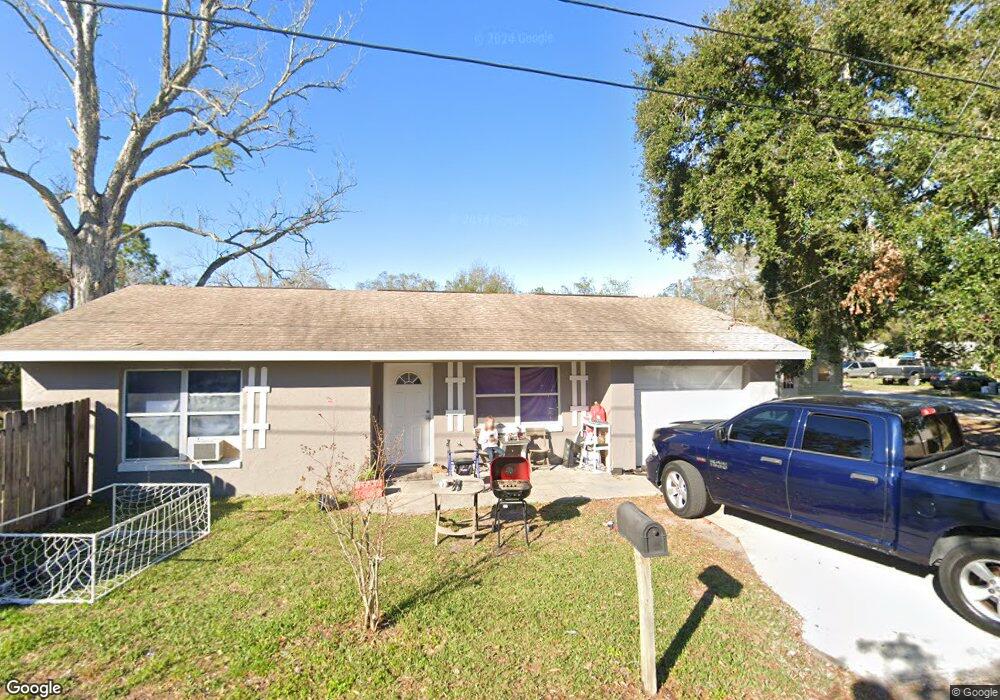
201 NW 6th St Mulberry, FL 33860
Estimated Value: $164,000 - $223,000
3
Beds
1
Bath
846
Sq Ft
$222/Sq Ft
Est. Value
About This Home
This home is located at 201 NW 6th St, Mulberry, FL 33860 and is currently estimated at $188,031, approximately $222 per square foot. 201 NW 6th St is a home located in Polk County with nearby schools including Purcell Elementary School, Bartow Elementary Academy, and Mulberry Middle School.
Ownership History
Date
Name
Owned For
Owner Type
Purchase Details
Closed on
Oct 31, 2013
Sold by
Liptak Brad Raymond
Bought by
C J Benefield Pa and 6Th Street Nw Land Trust #201
Current Estimated Value
Purchase Details
Closed on
Jan 26, 2006
Sold by
Ziranski Ronald E
Bought by
Liptak Brad and Liptak Amy
Home Financials for this Owner
Home Financials are based on the most recent Mortgage that was taken out on this home.
Original Mortgage
$53,100
Interest Rate
6.21%
Create a Home Valuation Report for This Property
The Home Valuation Report is an in-depth analysis detailing your home's value as well as a comparison with similar homes in the area
Home Values in the Area
Average Home Value in this Area
Purchase History
| Date | Buyer | Sale Price | Title Company |
|---|---|---|---|
| C J Benefield Pa | -- | Attorney | |
| Liptak Brad | $59,000 | None Available |
Source: Public Records
Mortgage History
| Date | Status | Borrower | Loan Amount |
|---|---|---|---|
| Previous Owner | Liptak Brad | $53,100 |
Source: Public Records
Tax History Compared to Growth
Tax History
| Year | Tax Paid | Tax Assessment Tax Assessment Total Assessment is a certain percentage of the fair market value that is determined by local assessors to be the total taxable value of land and additions on the property. | Land | Improvement |
|---|---|---|---|---|
| 2025 | $2,448 | $109,718 | -- | -- |
| 2024 | $2,303 | $99,744 | -- | -- |
| 2023 | $2,303 | $90,676 | $0 | $0 |
| 2022 | $2,163 | $82,433 | $0 | $0 |
| 2021 | $1,848 | $74,939 | $0 | $0 |
| 2020 | $1,685 | $82,924 | $5,006 | $77,918 |
| 2018 | $1,425 | $66,340 | $4,839 | $61,501 |
| 2017 | $1,315 | $50,501 | $0 | $0 |
| 2016 | $1,193 | $45,910 | $0 | $0 |
| 2015 | $968 | $44,815 | $0 | $0 |
| 2014 | $1,016 | $40,286 | $0 | $0 |
Source: Public Records
Map
Nearby Homes
- 602 NW 1st Ave
- 503 NW 1st Ave Unit A & B
- 707 NW 2nd Ave
- 103 NW 5th St
- 211 NW 8th St
- 610 NW Phosphate Blvd
- 111 NE 1st Ave
- 202 E Badcock Blvd
- 322 NE 9th St
- 1420 Portmore Dr
- 1124 Aruba Ave
- 1412 Portmore Dr
- 208 SW 3rd Ave
- 809 W Canal St
- 925 NW 8th St
- 820 NW 9th St
- 996 Aruba Ave
- 120 Lake Pointe Dr
- 311 SW 3rd Ave
- 125 Lake Michigan Dr
- 604 NW 1st Ave
- 508 NW 1st Ave
- 603 NW 1st Ave
- 605 NW 1st Ave
- 605 NW 2nd Ave
- 606 NW 1st Ave
- 511 NW 2nd Ave
- 607 NW 1st Ave
- 507 NW 1st Ave
- 607 NW 2nd Ave
- 601 NW 2nd Ave
- 509 NW 2nd Ave
- 504 NW 1st Ave
- 609 NW 1st Ave
- 505 NW 1st Ave
- 507 NW 2nd Ave
- 502 NW 1st Ave
- 503 NW 1st Ave Unit A
- 604 N Church Ave
- 505 NW 2nd Ave