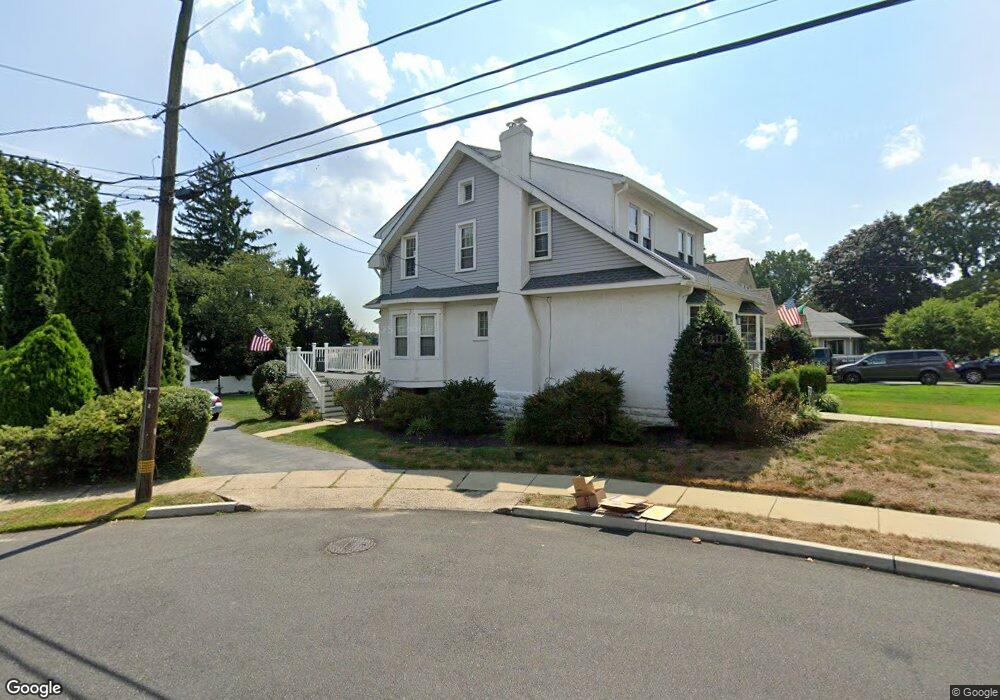
201 Orchard Rd Springfield, PA 19064
Estimated Value: $493,139 - $543,000
4
Beds
2
Baths
1,725
Sq Ft
$298/Sq Ft
Est. Value
About This Home
This home is located at 201 Orchard Rd, Springfield, PA 19064 and is currently estimated at $513,535, approximately $297 per square foot. 201 Orchard Rd is a home located in Delaware County with nearby schools including Springfield High School, St Francis Of Assisi School, and Holy Cross School.
Ownership History
Date
Name
Owned For
Owner Type
Purchase Details
Closed on
Aug 30, 2021
Sold by
Estate Of Kathleen Mcknight
Bought by
Mcknight Kevin F
Current Estimated Value
Home Financials for this Owner
Home Financials are based on the most recent Mortgage that was taken out on this home.
Original Mortgage
$384,940
Interest Rate
3.09%
Mortgage Type
New Conventional
Purchase Details
Closed on
Sep 19, 1974
Bought by
Mcknight Francis and Mcknight Kath
Create a Home Valuation Report for This Property
The Home Valuation Report is an in-depth analysis detailing your home's value as well as a comparison with similar homes in the area
Home Values in the Area
Average Home Value in this Area
Purchase History
| Date | Buyer | Sale Price | Title Company |
|---|---|---|---|
| Mcknight Kevin F | $400,000 | Sage Premier | |
| Mcknight Francis | -- | -- |
Source: Public Records
Mortgage History
| Date | Status | Borrower | Loan Amount |
|---|---|---|---|
| Previous Owner | Mcknight Kevin F | $384,940 |
Source: Public Records
Tax History
| Year | Tax Paid | Tax Assessment Tax Assessment Total Assessment is a certain percentage of the fair market value that is determined by local assessors to be the total taxable value of land and additions on the property. | Land | Improvement |
|---|---|---|---|---|
| 2025 | $7,395 | $263,110 | $97,920 | $165,190 |
| 2024 | $7,395 | $263,110 | $97,920 | $165,190 |
| 2023 | $7,121 | $263,110 | $97,920 | $165,190 |
| 2022 | $6,967 | $263,110 | $97,920 | $165,190 |
| 2021 | $10,789 | $263,110 | $97,920 | $165,190 |
| 2020 | $6,139 | $135,470 | $47,080 | $88,390 |
| 2019 | $5,995 | $135,470 | $47,080 | $88,390 |
| 2018 | $5,909 | $135,470 | $0 | $0 |
| 2017 | $5,772 | $135,470 | $0 | $0 |
| 2016 | $743 | $135,470 | $0 | $0 |
| 2015 | $759 | $135,470 | $0 | $0 |
| 2014 | $759 | $135,470 | $0 | $0 |
Source: Public Records
Map
Nearby Homes
- 111 Forest Rd
- 120 W Springfield Rd
- 31 Wayfield Rd
- 226 Lynbrooke Rd
- 364 S Rolling Rd
- 227 E Leamy Ave
- 147 Snyder Ln
- 29 School Ln
- 606 W Springfield Rd
- 332 Franklin Ave
- 220 N Rolling Rd
- 493 Wheatsheaf Rd
- 501 Flora Cir
- 641 W Sproul Rd
- 173 Rambling Way
- 412 N Rolling Rd
- 1291 Country Club Dr Unit Q137
- 1299 Country Club Dr Unit Q141
- 472 Larchwood Rd
- 114 Providence Rd
- 205 Orchard Rd
- 159 Orchard Rd
- 209 Orchard Rd
- 215 Orchard Rd
- 158 Orchard Rd
- 122 Wyndmoor Rd
- 118 Wyndmoor Rd
- 114 Wyndmoor Rd
- 126 Wyndmoor Rd
- 148 Orchard Rd
- 110 Wyndmoor Rd
- 219 Orchard Rd
- 130 Wyndmoor Rd
- 106 Wyndmoor Rd
- 200 Orchard Rd
- 134 Wyndmoor Rd
- 212 Orchard Rd
- 82 Lownes Ln
- 71 Briarwood Rd
- 100 Wyndmoor Rd
Your Personal Tour Guide
Ask me questions while you tour the home.