Estimated Value: $2,917,000 - $3,748,524
3
Beds
3
Baths
2,893
Sq Ft
$1,191/Sq Ft
Est. Value
About This Home
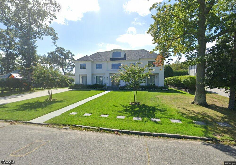
This home is located at 201 Parker Ave, Deal, NJ 07723 and is currently estimated at $3,446,631, approximately $1,191 per square foot. 201 Parker Ave is a home located in Monmouth County with nearby schools including Ocean Township High School, St. Mary of the Assumption School, and Ma'or Yeshiva High School for Boys.
Ownership History
Date
Name
Owned For
Owner Type
Purchase Details
Closed on
May 18, 2010
Sold by
Jacobson Ira and Jacobson Helene
Bought by
Shama Jack
Current Estimated Value
Home Financials for this Owner
Home Financials are based on the most recent Mortgage that was taken out on this home.
Original Mortgage
$380,000
Outstanding Balance
$236,235
Interest Rate
3.62%
Mortgage Type
New Conventional
Estimated Equity
$3,210,396
Create a Home Valuation Report for This Property
The Home Valuation Report is an in-depth analysis detailing your home's value as well as a comparison with similar homes in the area
Home Values in the Area
Average Home Value in this Area
Purchase History
| Date | Buyer | Sale Price | Title Company |
|---|---|---|---|
| Shama Jack | $999,999 | Old Republic National Title |
Source: Public Records
Mortgage History
| Date | Status | Borrower | Loan Amount |
|---|---|---|---|
| Open | Shama Jack | $380,000 |
Source: Public Records
Tax History Compared to Growth
Tax History
| Year | Tax Paid | Tax Assessment Tax Assessment Total Assessment is a certain percentage of the fair market value that is determined by local assessors to be the total taxable value of land and additions on the property. | Land | Improvement |
|---|---|---|---|---|
| 2025 | $43,125 | $3,258,400 | $1,752,000 | $1,506,400 |
| 2024 | $24,050 | $3,024,200 | $1,552,000 | $1,472,200 |
| 2023 | $24,050 | $1,572,900 | $1,202,000 | $370,900 |
| 2022 | $25,743 | $1,536,100 | $1,183,000 | $353,100 |
| 2021 | $25,743 | $1,310,100 | $1,007,000 | $303,100 |
| 2020 | $22,184 | $1,114,200 | $838,000 | $276,200 |
| 2019 | $20,647 | $1,012,600 | $738,000 | $274,600 |
| 2018 | $19,679 | $939,800 | $678,000 | $261,800 |
| 2017 | $17,045 | $810,500 | $563,000 | $247,500 |
| 2016 | $16,981 | $726,300 | $527,300 | $199,000 |
| 2015 | $16,653 | $696,900 | $527,300 | $169,600 |
| 2014 | $15,994 | $702,100 | $527,300 | $174,800 |
Source: Public Records
Map
Nearby Homes
- 10 Campbell Ct
- 1 Country Club Dr
- 408 Crosby Ave
- 460 Runyan Ave
- 116 Phillips Ave
- 504 Crosby Ave
- 404 Brookside Ave
- 0 Overbrook Ave
- 328 Elberon Blvd
- 160 Ocean Ave
- 306 Roosevelt Ave
- 267 Roosevelt Ave
- 18 Lady Bess Dr
- 296 Garfield Ave
- 210 Larchwood Ave
- 510 Blanchard Pkwy
- 271 Jerome Ave
- 243 Woodcrest Rd
- 608 Wildwood Rd
- 34 Bruns Rd
- 333 Holly Terrace
- 207 Parker Ave
- 200 Runyan Ave
- 222 Runyan Ave
- 209 Parker Ave
- 200 Parker Ave
- 330 Holly Terrace
- 210 Parker Ave
- 300 Holly Terrace
- 250 Parker Ave
- 107 Parker Ave
- 234 Runyan Ave
- 211 Parker Ave
- 448 Holly Terrace
- 106 Parker Ave
- 110 Runyan Ave
- 217 Runyan Ave
- 203 Holly Terrace
- 105 Parker Ave
- 225 Runyan Ave