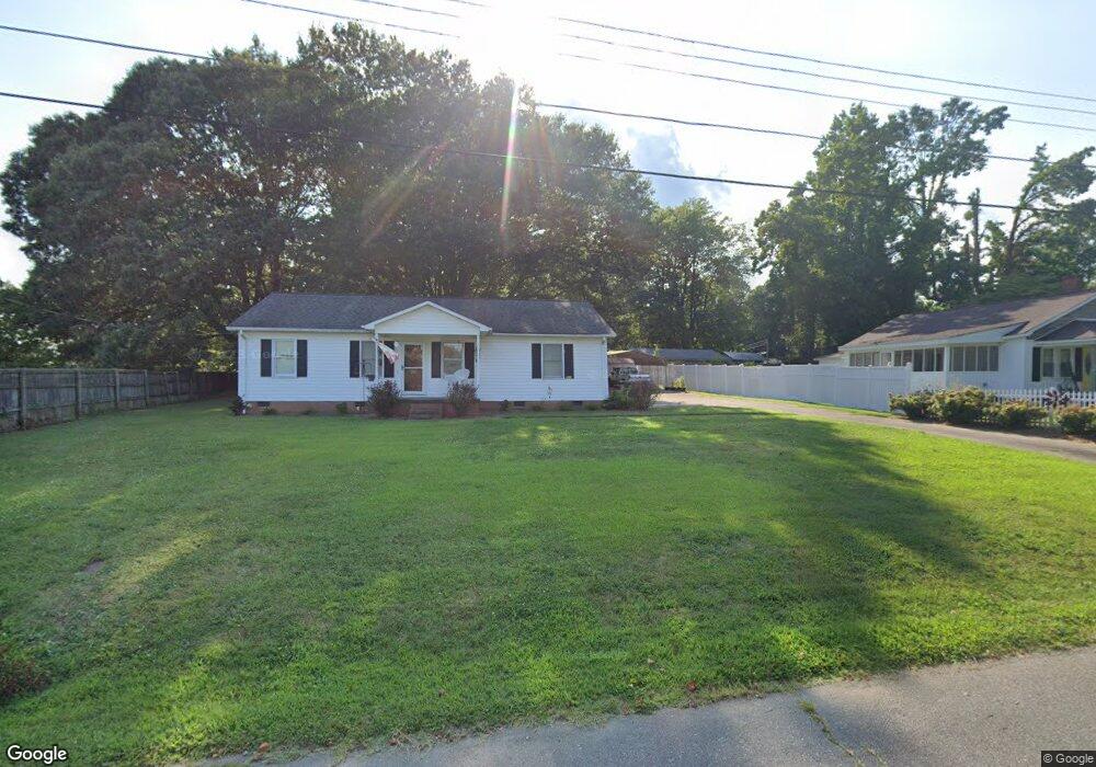
201 Ramsey St Cherryville, NC 28021
Estimated Value: $166,475 - $225,000
2
Beds
1
Bath
820
Sq Ft
$229/Sq Ft
Est. Value
About This Home
This home is located at 201 Ramsey St, Cherryville, NC 28021 and is currently estimated at $187,869, approximately $229 per square foot. 201 Ramsey St is a home located in Gaston County with nearby schools including Cherryville Elementary School, William B. Beam Intermediate School, and John Chavis Middle School.
Ownership History
Date
Name
Owned For
Owner Type
Purchase Details
Closed on
Aug 12, 2013
Sold by
Johnson Pamela Brown
Bought by
Sneed Carl L and Sneed Betty S
Current Estimated Value
Home Financials for this Owner
Home Financials are based on the most recent Mortgage that was taken out on this home.
Original Mortgage
$64,500
Outstanding Balance
$47,774
Interest Rate
4.29%
Mortgage Type
VA
Estimated Equity
$140,095
Purchase Details
Closed on
May 3, 2005
Sold by
Fowler Hershel Louie and Fowler Joan Mauney
Bought by
Brown Clyde Buford
Home Financials for this Owner
Home Financials are based on the most recent Mortgage that was taken out on this home.
Original Mortgage
$15,000
Interest Rate
5.99%
Mortgage Type
Purchase Money Mortgage
Create a Home Valuation Report for This Property
The Home Valuation Report is an in-depth analysis detailing your home's value as well as a comparison with similar homes in the area
Home Values in the Area
Average Home Value in this Area
Purchase History
| Date | Buyer | Sale Price | Title Company |
|---|---|---|---|
| Sneed Carl L | $64,500 | None Available | |
| Brown Clyde Buford | $70,000 | First American Charlotte |
Source: Public Records
Mortgage History
| Date | Status | Borrower | Loan Amount |
|---|---|---|---|
| Open | Sneed Carl L | $64,500 | |
| Previous Owner | Brown Clyde Buford | $15,000 |
Source: Public Records
Tax History Compared to Growth
Tax History
| Year | Tax Paid | Tax Assessment Tax Assessment Total Assessment is a certain percentage of the fair market value that is determined by local assessors to be the total taxable value of land and additions on the property. | Land | Improvement |
|---|---|---|---|---|
| 2025 | $1,574 | $145,910 | $13,000 | $132,910 |
| 2024 | $1,574 | $145,910 | $13,000 | $132,910 |
| 2023 | $1,590 | $145,910 | $13,000 | $132,910 |
| 2022 | $1,160 | $87,240 | $9,000 | $78,240 |
| 2021 | $1,178 | $87,240 | $9,000 | $78,240 |
| 2019 | $1,134 | $87,240 | $9,000 | $78,240 |
| 2018 | $919 | $69,090 | $8,400 | $60,690 |
| 2017 | $906 | $69,090 | $8,400 | $60,690 |
| 2016 | $906 | $68,090 | $0 | $0 |
| 2014 | $1,021 | $76,788 | $10,500 | $66,288 |
Source: Public Records
Map
Nearby Homes
- 197 Dale Dr
- 201 Dale Dr
- 106 Guffey Rd
- 211 Roy Eaker Rd
- 1008 Rocky Ridge Dr
- 5.68 acres Rosewood Ln
- 458 Roy Eaker Rd
- 00 Muirfield Dr
- 01 Muirfield Dr
- 709 E Main St
- 1015 E Academy St
- 302 N Houser St
- 111 Sussex Ave
- 404 Kings Dr
- 400 N Houser St
- 4050 Muirfield Dr
- 000 Lawrence Rd
- 543 Roy Eaker Rd
- 704 Hawthorne St
- 600 Queens Rd
- 203 Ramsey St
- 1503 E Church St
- 200 Dale Dr
- 200 Ramsey St
- 205 Ramsey St
- 1501 E Church St
- 202 Ramsey St
- 1601 E Church St
- 202 Dale Dr
- 204 Ramsey St
- 207 Ramsey St
- 1603 E Church St
- 1409 E Church St
- 1602 E Church St
- 1600 E Church St
- 203 Dale Dr
- 1504 E Church St
- 206 Dale Dr
- 1502 E Church St
- 5201 Dellinger Cir