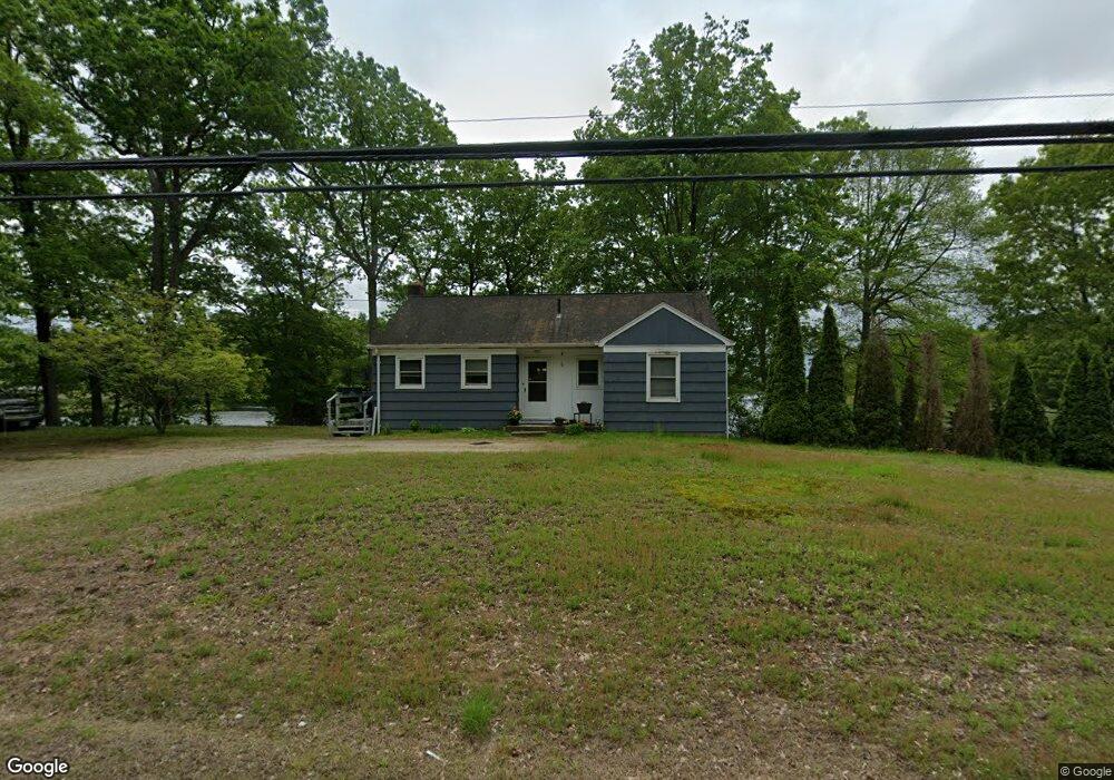
201 Route 2a Preston, CT 06365
Estimated Value: $293,000 - $312,294
2
Beds
1
Bath
916
Sq Ft
$328/Sq Ft
Est. Value
About This Home
This home is located at 201 Route 2a, Preston, CT 06365 and is currently estimated at $300,574, approximately $328 per square foot. 201 Route 2a is a home located in New London County with nearby schools including Integrated Day Charter School, St. Bernard School, and Saint Bernard School.
Ownership History
Date
Name
Owned For
Owner Type
Purchase Details
Closed on
Sep 8, 2023
Sold by
Hill Bessie C
Bought by
Hill Dale F
Current Estimated Value
Purchase Details
Closed on
Sep 7, 2021
Sold by
Ruth M Morton Ret and Morton
Bought by
Hill Bessie C
Home Financials for this Owner
Home Financials are based on the most recent Mortgage that was taken out on this home.
Original Mortgage
$184,300
Interest Rate
2.8%
Mortgage Type
Purchase Money Mortgage
Create a Home Valuation Report for This Property
The Home Valuation Report is an in-depth analysis detailing your home's value as well as a comparison with similar homes in the area
Home Values in the Area
Average Home Value in this Area
Purchase History
| Date | Buyer | Sale Price | Title Company |
|---|---|---|---|
| Hill Dale F | -- | None Available | |
| Hill Bessie C | $190,000 | None Available |
Source: Public Records
Mortgage History
| Date | Status | Borrower | Loan Amount |
|---|---|---|---|
| Previous Owner | Hill Bessie C | $184,300 |
Source: Public Records
Tax History Compared to Growth
Tax History
| Year | Tax Paid | Tax Assessment Tax Assessment Total Assessment is a certain percentage of the fair market value that is determined by local assessors to be the total taxable value of land and additions on the property. | Land | Improvement |
|---|---|---|---|---|
| 2025 | $4,078 | $162,400 | $78,540 | $83,860 |
| 2024 | $3,795 | $162,400 | $78,540 | $83,860 |
| 2023 | $3,727 | $162,400 | $78,540 | $83,860 |
| 2022 | $3,309 | $118,700 | $61,600 | $57,100 |
| 2021 | $3,198 | $118,700 | $61,600 | $57,100 |
| 2020 | $3,193 | $118,700 | $61,600 | $57,100 |
| 2019 | $3,137 | $118,700 | $61,600 | $57,100 |
| 2018 | $3,090 | $118,700 | $61,600 | $57,100 |
| 2017 | $2,748 | $114,500 | $53,000 | $61,500 |
| 2016 | $2,719 | $114,500 | $53,000 | $61,500 |
| 2015 | $2,634 | $114,500 | $53,000 | $61,500 |
| 2014 | $2,650 | $114,500 | $53,000 | $61,500 |
Source: Public Records
Map
Nearby Homes
- 178 Route 2a
- 7 Barn Rd
- 6 Arrowhead Dr
- 5 Arrowhead Dr
- 59 Harris Fuller Rd
- 104 Route 2a
- 140 Route 12
- 6 Route 117
- 3 Holdsworth Rd
- 15 Drawbridge Rd
- 3 Webster Dr
- 34 Ridgewood Dr
- 16 Marlene Dr
- 146 Route 2
- 5 Bittersweet Dr
- 15 Paster Rd
- 145 Massapeag Side Rd
- 547 Old Laurel Hill Rd
- 5 Mount Laurel Rd
- 102 Lucas Park Rd
- 202 Route 2a
- 206 Route 2a
- 200 Route 2a
- 2 Harris Fuller Rd
- 196 Route 2a
- 6 Harris Fuller Rd
- 212 Route 2a
- 214 Route 2a
- 9 Harris Fuller Rd
- 16 Harris Fuller Rd
- 11 Royal Oaks Dr
- 14 Harris Fuller Rd
- 3 Green Point St
- 11 Harris Fuller Rd
- 9 Royal Oaks Dr
- 10 Royal Oaks Dr
- 7 Royal Oaks Dr
- 5 Green Point St
- 44 Arrowhead Dr
- 49 Arrowhead Dr