Estimated Value: $113,069 - $137,000
2
Beds
1
Bath
832
Sq Ft
$145/Sq Ft
Est. Value
About This Home
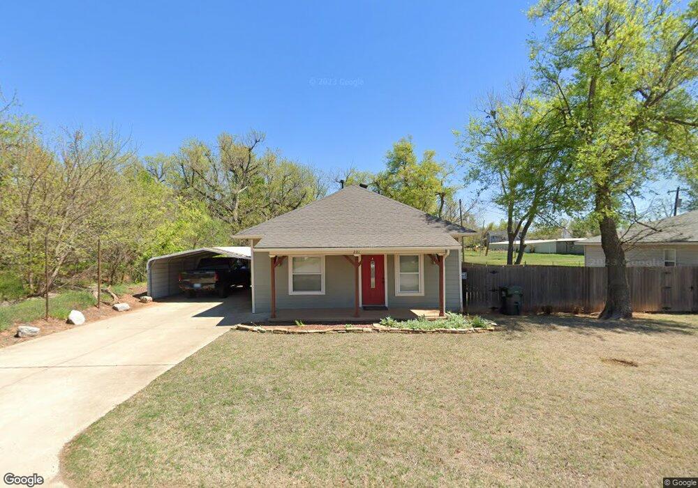
This home is located at 201 S 2nd St, Yukon, OK 73099 and is currently estimated at $120,517, approximately $144 per square foot. 201 S 2nd St is a home with nearby schools including Central Elementary School, Independence Elementary School, and Yukon Middle School.
Ownership History
Date
Name
Owned For
Owner Type
Purchase Details
Closed on
Apr 30, 2013
Sold by
Dodson Matthew R and Dodson Kara
Bought by
Greer Rodney
Current Estimated Value
Home Financials for this Owner
Home Financials are based on the most recent Mortgage that was taken out on this home.
Original Mortgage
$61,750
Outstanding Balance
$13,528
Interest Rate
3.58%
Mortgage Type
New Conventional
Estimated Equity
$106,989
Purchase Details
Closed on
Jun 5, 2005
Sold by
Fiarchild Gerald Leon
Bought by
Loyd Gail and Pairchild Gail
Purchase Details
Closed on
Oct 30, 1997
Sold by
Davis Steve T
Purchase Details
Closed on
Feb 17, 1997
Sold by
Davis Jean
Purchase Details
Closed on
May 19, 1995
Sold by
West Barry
Purchase Details
Closed on
May 11, 1995
Sold by
Rose Charles R and Rose Dorothy
Purchase Details
Closed on
Jan 31, 1973
Sold by
Klink Bernadena and Klink Alex
Create a Home Valuation Report for This Property
The Home Valuation Report is an in-depth analysis detailing your home's value as well as a comparison with similar homes in the area
Home Values in the Area
Average Home Value in this Area
Purchase History
| Date | Buyer | Sale Price | Title Company |
|---|---|---|---|
| Greer Rodney | $65,000 | Ort | |
| Loyd Gail | -- | None Available | |
| -- | $35,000 | -- | |
| -- | -- | -- | |
| -- | $13,000 | -- | |
| -- | $5,000 | -- | |
| -- | $5,000 | -- |
Source: Public Records
Mortgage History
| Date | Status | Borrower | Loan Amount |
|---|---|---|---|
| Open | Greer Rodney | $61,750 |
Source: Public Records
Tax History Compared to Growth
Tax History
| Year | Tax Paid | Tax Assessment Tax Assessment Total Assessment is a certain percentage of the fair market value that is determined by local assessors to be the total taxable value of land and additions on the property. | Land | Improvement |
|---|---|---|---|---|
| 2024 | $466 | $5,459 | $1,137 | $4,322 |
| 2023 | $466 | $5,301 | $1,137 | $4,164 |
| 2022 | $451 | $5,146 | $1,137 | $4,009 |
| 2021 | $436 | $4,997 | $1,137 | $3,860 |
| 2020 | $415 | $4,851 | $1,137 | $3,714 |
| 2019 | $401 | $4,710 | $1,137 | $3,573 |
| 2018 | $388 | $4,573 | $1,137 | $3,436 |
| 2017 | $379 | $4,491 | $1,137 | $3,354 |
| 2016 | $365 | $4,408 | $1,137 | $3,271 |
| 2015 | $363 | $4,233 | $1,137 | $3,096 |
| 2014 | $363 | $4,296 | $1,137 | $3,159 |
Source: Public Records
Map
Nearby Homes
- 11817 Corie Nicole Ln
- 4601 Grassland Dr
- 2117 Aminas Way
- 12033 SW 31st St
- 12100 Birch Ave
- 12201 Birch Ave
- 3608 Northover Ridge Dr
- 3509 Sawtooth Ridge Dr
- 10401 NW 33rd St
- 11020 SW 34th Terrace
- 121 Birch Ave
- 2001 Aminas Way
- 11033 NW 20th Terrace
- 210 N 4th St
- 224 N 3rd St
- 316 Ash Ave
- 502 Walnut Ave
- 11200 SW 32nd St
- 11717 Annette Dr
- 9509 NW 118th St