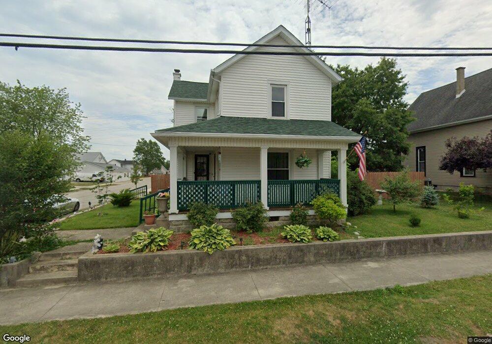
201 S High St Arcanum, OH 45304
Estimated Value: $189,000 - $211,887
3
Beds
2
Baths
1,726
Sq Ft
$115/Sq Ft
Est. Value
About This Home
This home is located at 201 S High St, Arcanum, OH 45304 and is currently estimated at $198,972, approximately $115 per square foot. 201 S High St is a home located in Darke County with nearby schools including Arcanum Elementary School, Butler Middle School, and Arcanum High School.
Ownership History
Date
Name
Owned For
Owner Type
Purchase Details
Closed on
Feb 28, 2022
Sold by
Hulett Jon E and Hulett Leslie
Bought by
Blankenship James and Blankenship Ivan
Current Estimated Value
Home Financials for this Owner
Home Financials are based on the most recent Mortgage that was taken out on this home.
Original Mortgage
$115,150
Outstanding Balance
$106,817
Interest Rate
3.69%
Mortgage Type
New Conventional
Estimated Equity
$92,155
Purchase Details
Closed on
Aug 23, 2019
Sold by
Pyles Jack L
Bought by
Hulett Jon E and Hulett Leslie
Home Financials for this Owner
Home Financials are based on the most recent Mortgage that was taken out on this home.
Original Mortgage
$68,875
Interest Rate
3.7%
Mortgage Type
New Conventional
Purchase Details
Closed on
Nov 6, 2003
Sold by
Smith Rae Ann and Smith Jerrie V
Bought by
Pyles Jack L
Purchase Details
Closed on
Oct 28, 2003
Sold by
Estate Of Anna Mae Pyles
Bought by
Pyles Jack L and Smith Rae Ann
Create a Home Valuation Report for This Property
The Home Valuation Report is an in-depth analysis detailing your home's value as well as a comparison with similar homes in the area
Home Values in the Area
Average Home Value in this Area
Purchase History
| Date | Buyer | Sale Price | Title Company |
|---|---|---|---|
| Blankenship James | $164,500 | Chicago Title | |
| Hulett Jon E | $72,500 | None Available | |
| Pyles Jack L | -- | -- | |
| Pyles Jack L | -- | -- |
Source: Public Records
Mortgage History
| Date | Status | Borrower | Loan Amount |
|---|---|---|---|
| Open | Blankenship James | $115,150 | |
| Previous Owner | Hulett Jon E | $68,875 |
Source: Public Records
Tax History Compared to Growth
Tax History
| Year | Tax Paid | Tax Assessment Tax Assessment Total Assessment is a certain percentage of the fair market value that is determined by local assessors to be the total taxable value of land and additions on the property. | Land | Improvement |
|---|---|---|---|---|
| 2024 | $2,071 | $55,240 | $9,840 | $45,400 |
| 2023 | $2,095 | $55,240 | $9,840 | $45,400 |
| 2022 | $1,262 | $29,470 | $8,200 | $21,270 |
| 2021 | $1,217 | $29,470 | $8,200 | $21,270 |
| 2020 | $1,182 | $29,470 | $8,200 | $21,270 |
| 2019 | $1,048 | $25,930 | $8,200 | $17,730 |
| 2018 | $1,011 | $25,930 | $8,200 | $17,730 |
| 2017 | $967 | $25,930 | $8,200 | $17,730 |
| 2016 | $968 | $26,080 | $8,830 | $17,250 |
| 2015 | $968 | $26,080 | $8,830 | $17,250 |
| 2014 | $980 | $26,080 | $8,830 | $17,250 |
| 2013 | $1,034 | $26,080 | $8,830 | $17,250 |
Source: Public Records
Map
Nearby Homes
- 104 E 1st St
- 206 W George St
- 304 S Locust St
- 201 W George St
- 111 N Main St
- 507 S High St
- 20 Seminole Ln
- 6987 Alternate State Route 49
- 3 Harvest Dr
- 13 Harvest Dr
- 18 Greenmoor Dr
- 3 Greenmoor Dr
- Alt St Rt 49 Alt State Route 49
- 2 Edgewood Dr
- 7231 Dull Rd
- 2546 Gordon Landis Rd
- 3794 State Route 49
- 3847 Drew Rd
- 3878 State Route 49
- 0 Delisle Fourman Rd