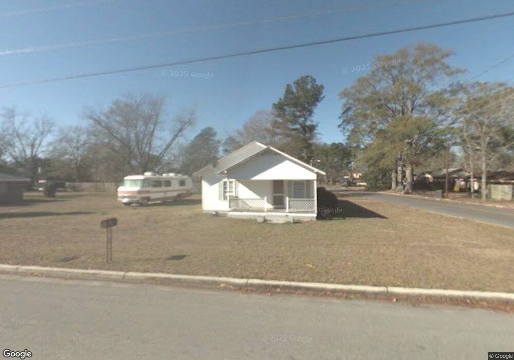
201 S Ralph St Claxton, GA 30417
Estimated Value: $67,000 - $106,000
3
Beds
1
Bath
864
Sq Ft
$96/Sq Ft
Est. Value
About This Home
This home is located at 201 S Ralph St, Claxton, GA 30417 and is currently estimated at $83,023, approximately $96 per square foot. 201 S Ralph St is a home located in Evans County with nearby schools including Claxton Elementary School, Second Chance, and Claxton Middle School.
Ownership History
Date
Name
Owned For
Owner Type
Purchase Details
Closed on
Jul 23, 2021
Sold by
Fulton Kerry House
Bought by
Guadalupe Marco and Guadalupe Severino
Current Estimated Value
Purchase Details
Closed on
Jun 14, 2021
Sold by
House George Carlton
Bought by
Fulton Kerry House
Purchase Details
Closed on
Apr 2, 2007
Sold by
Not Provided
Bought by
House George C
Purchase Details
Closed on
Oct 27, 2006
Sold by
Zhao Mei-Qing
Bought by
Wilkes Gene H
Purchase Details
Closed on
Jul 3, 2002
Sold by
Massey Nannie Kate D
Bought by
Zhao Mei Oing
Purchase Details
Closed on
Jun 19, 1991
Sold by
Sikes Larry David
Bought by
Massey Nannie Kate D
Create a Home Valuation Report for This Property
The Home Valuation Report is an in-depth analysis detailing your home's value as well as a comparison with similar homes in the area
Home Values in the Area
Average Home Value in this Area
Purchase History
| Date | Buyer | Sale Price | Title Company |
|---|---|---|---|
| Guadalupe Marco | $22,000 | -- | |
| Fulton Kerry House | -- | -- | |
| House George C | $39,000 | -- | |
| House George C | $39,000 | -- | |
| Wilkes Gene H | $27,000 | -- | |
| Zhao Mei Oing | $32,000 | -- | |
| Massey Nannie Kate D | $10,000 | -- |
Source: Public Records
Tax History Compared to Growth
Tax History
| Year | Tax Paid | Tax Assessment Tax Assessment Total Assessment is a certain percentage of the fair market value that is determined by local assessors to be the total taxable value of land and additions on the property. | Land | Improvement |
|---|---|---|---|---|
| 2024 | $572 | $21,240 | $3,000 | $18,240 |
| 2023 | $606 | $12,920 | $2,480 | $10,440 |
| 2022 | $468 | $12,920 | $2,480 | $10,440 |
| 2021 | $413 | $12,920 | $2,480 | $10,440 |
| 2020 | $414 | $12,920 | $2,480 | $10,440 |
| 2019 | $377 | $12,920 | $2,480 | $10,440 |
| 2018 | $372 | $12,720 | $2,480 | $10,240 |
| 2017 | $365 | $12,920 | $2,480 | $10,440 |
| 2016 | $371 | $13,040 | $2,480 | $10,560 |
| 2015 | -- | $13,840 | $2,480 | $11,360 |
| 2014 | -- | $13,840 | $2,480 | $11,360 |
| 2013 | -- | $14,040 | $2,480 | $11,560 |
Source: Public Records
Map
Nearby Homes
- 511 W Smith St
- 610 W Liberty St
- 606 Park Ave
- 3 S Spring St
- 107 Marguerite St
- 11 Marguerite St
- 6 N Spring St
- 206 New Dr
- 9 Honeysuckle Dr
- 201 New Dr
- 415 Burkhalter Cir
- 19 Wysteria Ln
- 10 Honeysuckle Dr
- 3 Honeysuckle Dr
- 0 Ga Hwy 129 N Unit 10564606
- 107 E Liberty St
- 308 Old Metter Rd
- 0 Dublin Rd
- 1717 Perkins Mill Rd
- 0 Turnpike Rd Unit SA339603